All Activity
- Past hour
-

Dec 6-7th (It's not a clipper) Clipper
cyclone77 replied to Chicago Storm's topic in Lakes/Ohio Valley
Took awhile but it's pouring pretty nicely now, smallish flakes. Looks like a half inch or so. -
So what I'm hearing is that I'm the Curry of HRRR extrapolations? Should put that on the wall and in my signature tbh
-

Mid to long range discussion- 2025
Leesville Wx Hawk replied to wncsnow's topic in Southeastern States
I wouldn’t worry about GFS losing some precipitation with NAM looking better. . -
New Bern, NC is south coastal NC. That is a terrible place to think it will snow.
-

Dec 6-7th (It's not a clipper) Clipper
McHenrySnow replied to Chicago Storm's topic in Lakes/Ohio Valley
It has begun. -

Dec 6-7th (It's not a clipper) Clipper
ChiTownSnow replied to Chicago Storm's topic in Lakes/Ohio Valley
https://share.google/images/oTxqIFSNUIUIbTdRX -
Freenzing fog, 28.9.
-
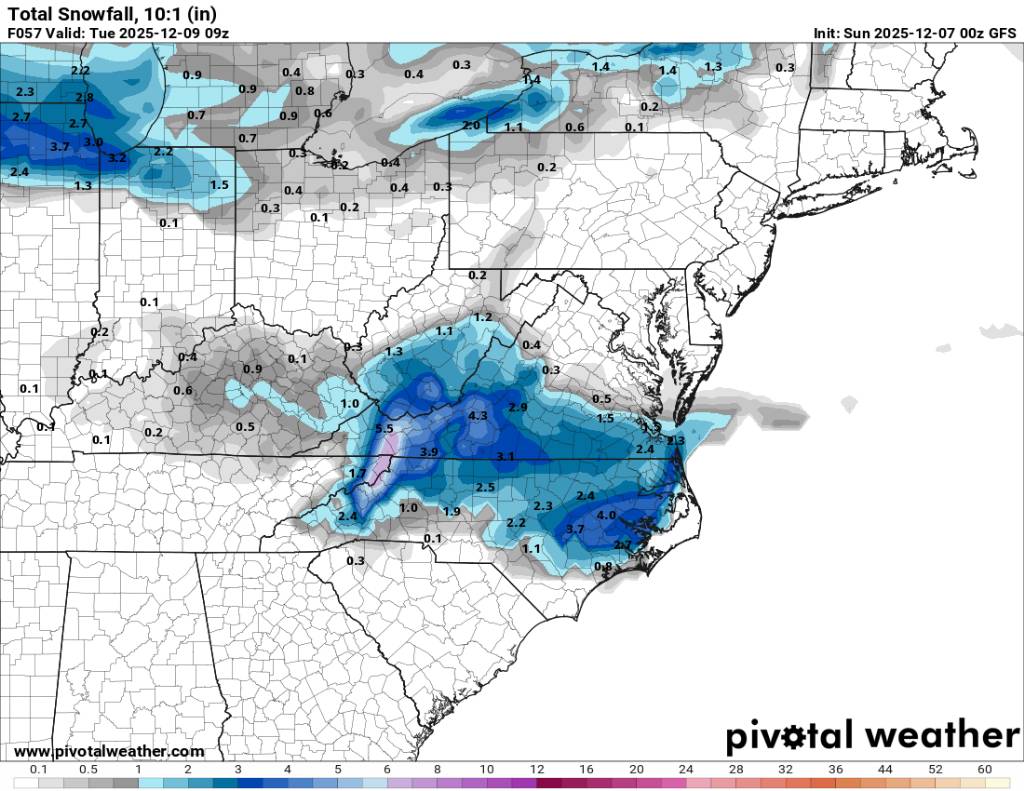
Its similar slightly less QPF western areas.
.thumb.png.ac8fff888971d9e3a65506409f8adcbe.png)
.thumb.png.f06957be679b2208fbcd3d5532f9beff.png)
-
Mid to long range discussion- 2025
Leesville Wx Hawk replied to wncsnow's topic in Southeastern States
Looks similar to previous run to me. . -
curry would make this tho
-
Not bad. I was hoping for it to continue increasing amounts. It was a slight decrease but similar overall
-
This looks to be a northern mountain special amd points eastward. Sent from my SM-G998U using Tapatalk

-
Still a solid run for sure!
-
What Nam?
-
GFS looks about the same...scoots just south of us
-
0.02" with the inverted nipple.
-
Super foggy and 32/33. Will be interesting to see if we have rime ice
-
And as other models beef up, the GFS looks a little more meager with precip this run
-
Yeah boundary layer temps look like an issue
-

Dec 6-7th (It's not a clipper) Clipper
hawkeye_wx replied to Chicago Storm's topic in Lakes/Ohio Valley
I have received 3 inches in a little over 3 hours. -

Mid to long range discussion- 2025
WinstonSalemArlington replied to wncsnow's topic in Southeastern States
And tends sniff out warm noses well, although this looks like surface temperatures will be the bigger challenge instead of aloft -
imma check it out!
-
Indeed
-
Dec 6-7th (It's not a clipper) Clipper
cyclone77 replied to Chicago Storm's topic in Lakes/Ohio Valley
A few tenths so far here after 2 hours. Been extremely light so far, but better radar returns are incoming. -
I don't think I've seen a Rocky Mountain single storm report with over 5 ft until now


.png.40752bb60eb50ca2a16d9a205a71600e.png)
.png.c16941f7f6463ddca428648056a88c5c.png)