All Activity
- Past hour
-

First Winter Storm to kickoff 2025-26 Winter season
Baroclinic Zone replied to Baroclinic Zone's topic in New England
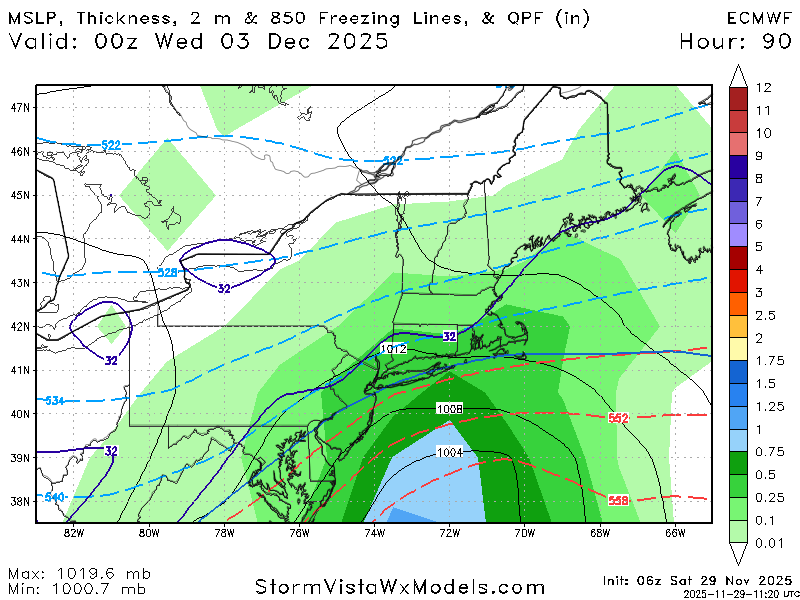
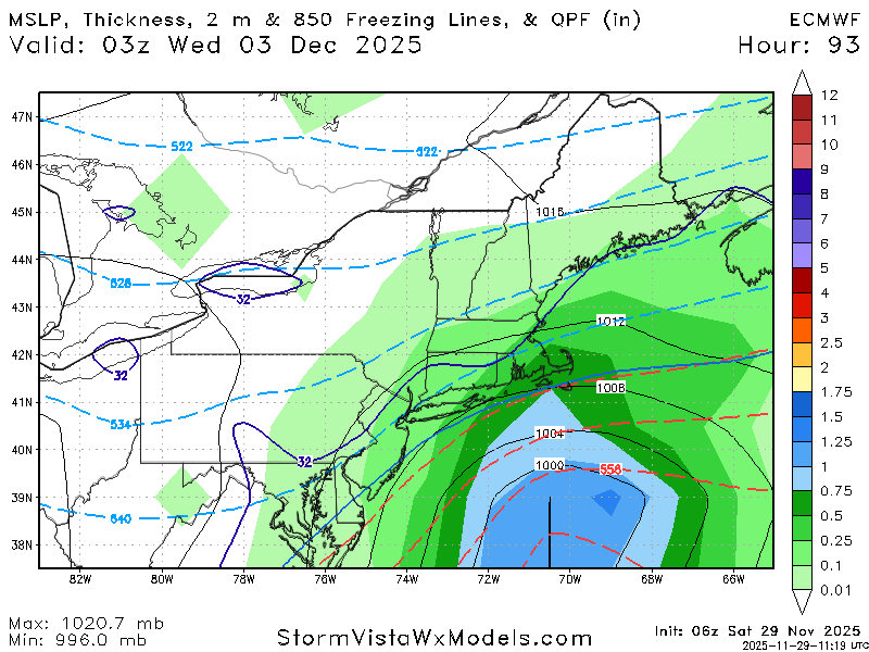
Overall trend I have seen is lowering/flattening of heights over the northeast. Vorticity itself looks to be more consolidated and has dug further south. Nice look on the overnight for interior SNE and up into CNE. -

Central PA Fall Discussions and Obs
mahantango#1 replied to ChescoWx's topic in Upstate New York/Pennsylvania
21 this morning, this is the coldest so far this season here. -
Nice. I'm not judging, just bustin balls. I put some lights outside on Labor Day Weekend as it's nice to sit out there in the evening with a cocktail under some lights. One of our trees goes up Columbus Weekend and gets decorated for fall/Thanksgiving. That tree will obviously now get decorated for Christmas and then for Saint Patrick's Day, after which it will get put away. It's the dark time of the year so I like to bring it some light.
-

First Winter Storm to kickoff 2025-26 Winter season
Damage In Tolland replied to Baroclinic Zone's topic in New England
Beer? -

First Winter Storm to kickoff 2025-26 Winter season
CoastalWx replied to Baroclinic Zone's topic in New England
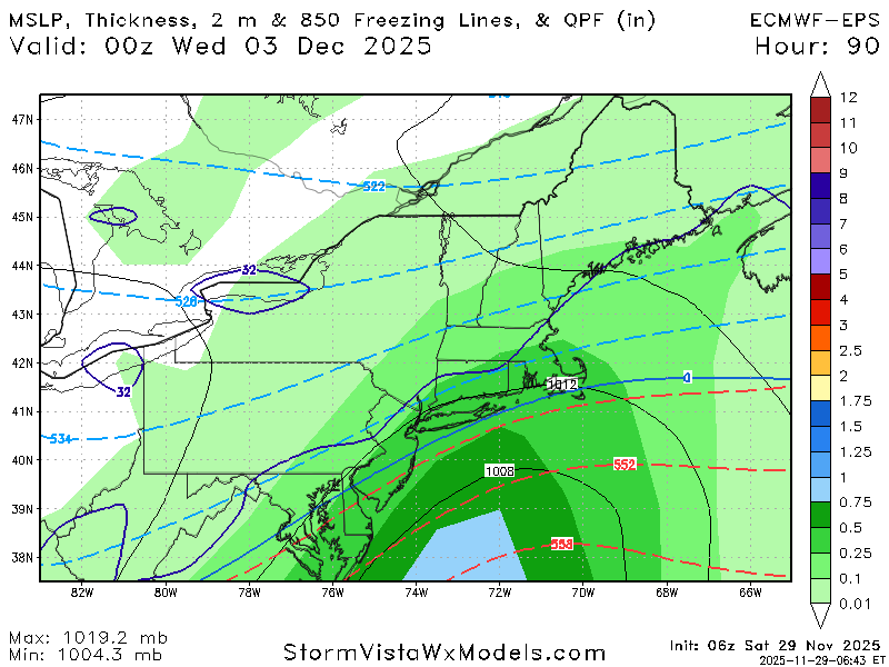
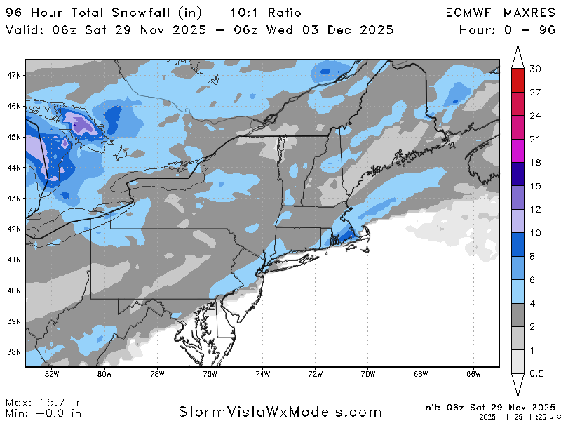
Yeah 6z euro is meager. 6z gfs is congrats you. -
-

First Winter Storm to kickoff 2025-26 Winter season
dendrite replied to Baroclinic Zone's topic in New England
6z eps way SE too. AI ens are still good for the interior. What a mess. -
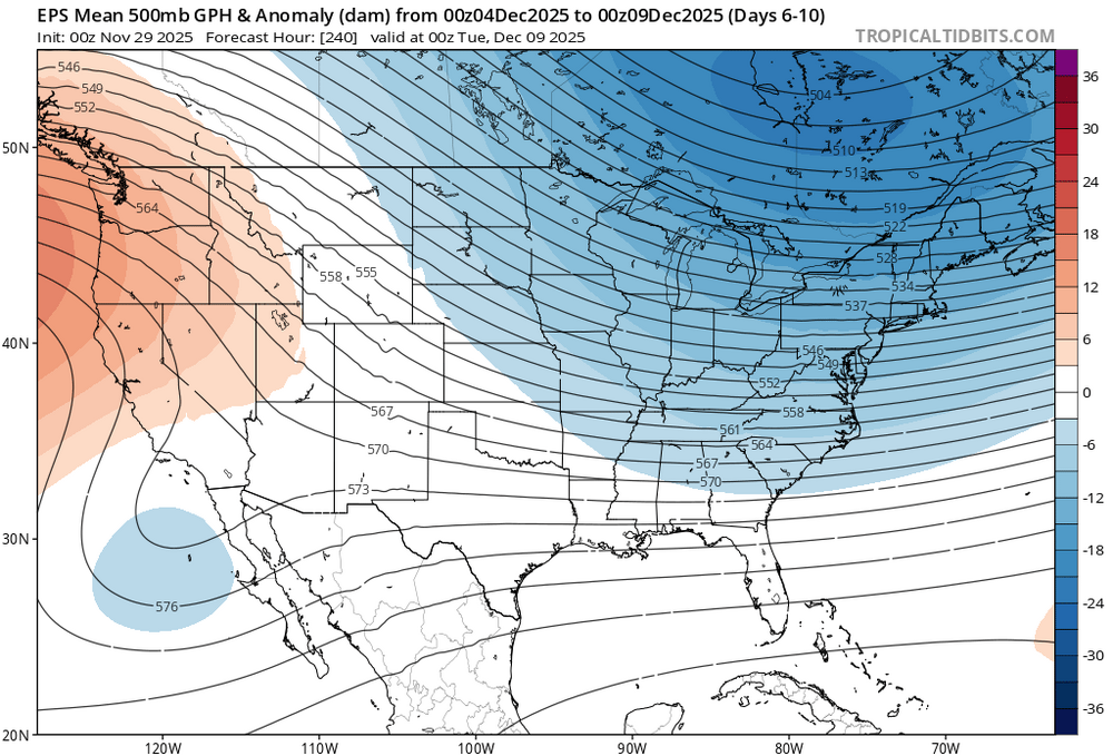
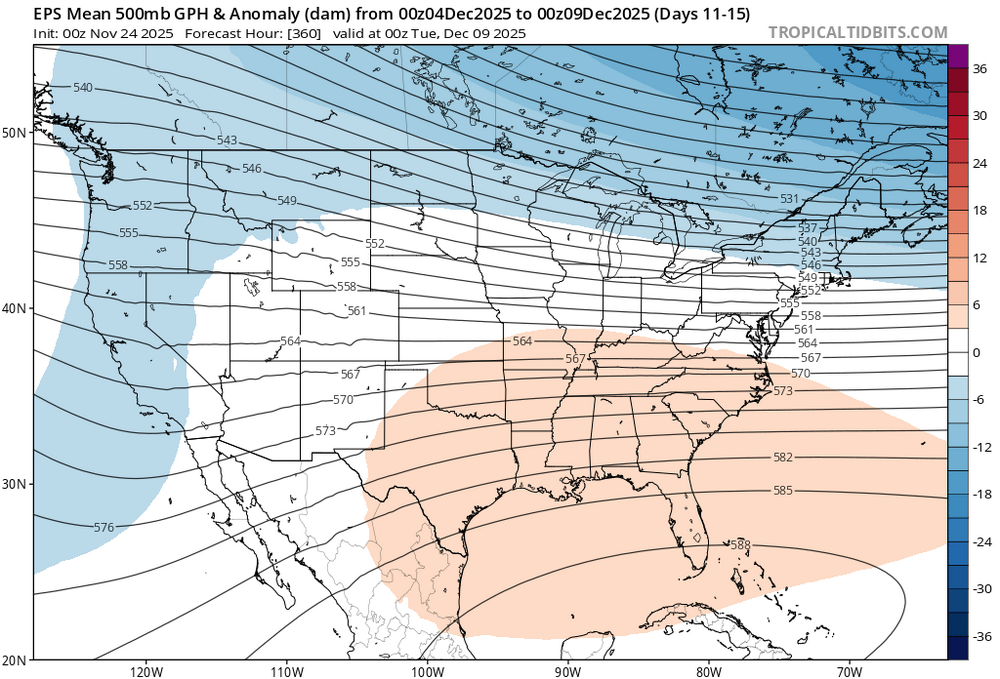
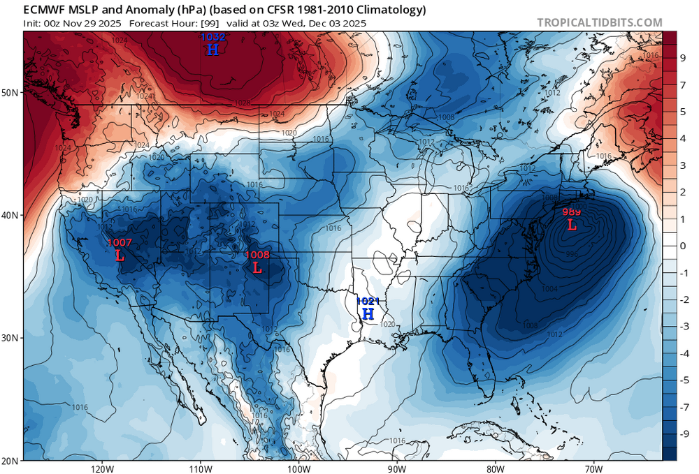
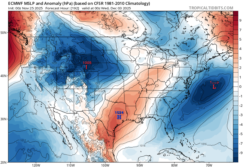
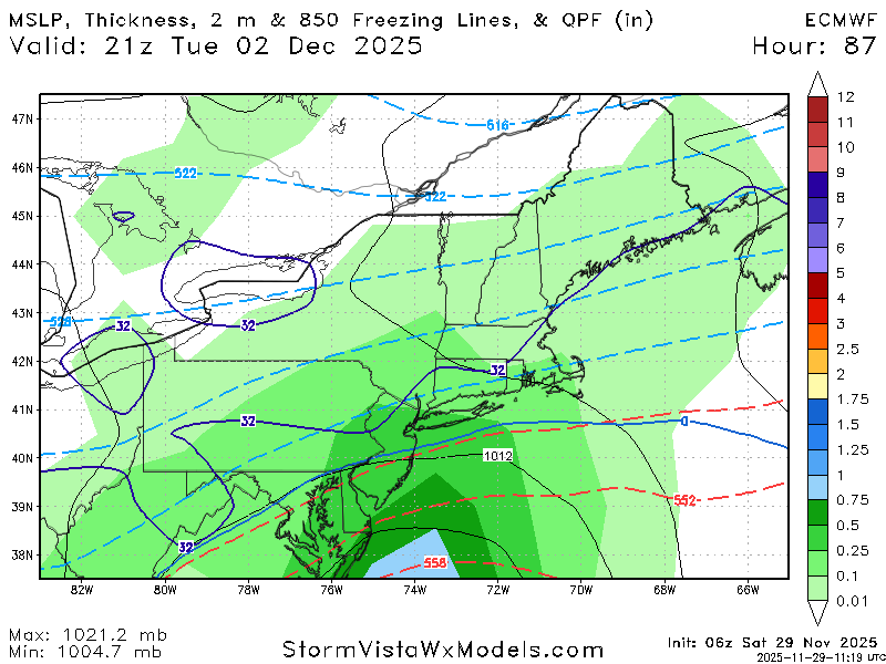
Looks like a split decision showing up for the first week of December. Long range models shifted colder with the trough into the East instead of the ridge from previous runs. But the large storm on the 2nd and 3rd shifted warmer with a further north track. Main issue with the storm is the very fast flow and lack of blocking allowed the high over New England to move off the coast. So the further north storm and slightly stronger WAR on the day of the storm pushed the rain to snow gradient just to the north and west of NYC. Since the colder start to December is a new pattern not showing up until day 6-10, it’s uncertain how the current day 11-15 will actually play out. If you look back on our recent Decembers, they have a tendency to start out cold from the 1st through 15th. Then we get the warm up every year since 2011 between the 17th and 25th. So it will be interesting to see how things actually play out vs what the models are currently showing. We would want to eventually see a colder storm for our area while we still have the cold. This is very important during La Nina’s since we need to get over 4” of snow in December to match the above vs below seasonal snowfall that I outlined a few days back in this thread. So hopefully we can connect with at least one storm next few weeks while the colder start is still nearby. New early December pattern colder than old runs Old run too warm for early December New run warmer storm further north on the 2nd and 3rd Old run storm track colder to the south and more suppressed
-
Nov 28-30th Post Turkey Day Winter Storm
Radtechwxman replied to Chicago Storm's topic in Lakes/Ohio Valley
Im a little concerned about this dry slot in northern MO. All that heavy precip by STL seems like it may skirt south of me. Hrrr suggests things will fill in later. We shall see -
Nov 28-30th Post Turkey Day Winter Storm
A-L-E-K replied to Chicago Storm's topic in Lakes/Ohio Valley
Nice base, avoiding screwholes so far -
My tree has been up since November 1. I have been done decorating since then. I wanted to do it earlier this year because wife is 30 weeks pregnant and we have alot coming up.
-

First Winter Storm to kickoff 2025-26 Winter season
dendrite replied to Baroclinic Zone's topic in New England
That’s cute but you forgot the 6z gfs -
And we thought all your decorations went up on November 1st each year
-
Nov 28-30th Post Turkey Day Winter Storm
ILSNOW replied to Chicago Storm's topic in Lakes/Ohio Valley
Dusting -
City should see a mix but just inland has a chance of accumulating snow Latest euro has came south and weaker.
-
Central PA Fall Discussions and Obs
Blizzard of 93 replied to ChescoWx's topic in Upstate New York/Pennsylvania
I like this part of CTP’s discussion! At this time, though, a plowable snowfall seems like a reasonable bet for most of the region. -
Central PA Fall Discussions and Obs
Blizzard of 93 replied to ChescoWx's topic in Upstate New York/Pennsylvania
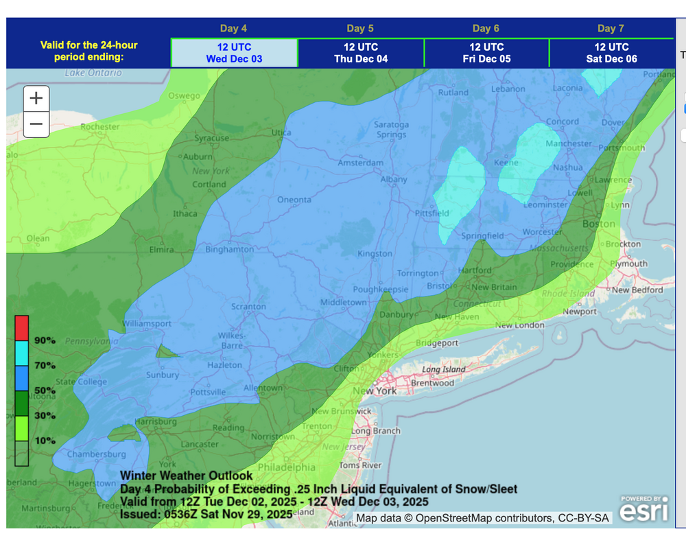
LONG TERM /MONDAY NIGHT THROUGH FRIDAY/... Unsettled weather will continue into the first week of December as cold air in the middle of the country sets up a strong baroclinic zone over the eastern US. High pressure in the Plains should keep cold air in place on the northern side of the precipitation shield from a wave of low pressure progged to move out of the Gulf. This system should move northeast around the base of the aforementioned high pressure system, bringing increasing moisture to the Mid-Atlantic Tuesday into Wednesday. The system at this time looks to be somewhat progressive with the lack of a strong area of high pressure to slow the advance of the system. Despite the expected fast forward movement, a deepening coastal low could still provide enough forcing juxtaposed with favorable upper jet dynamics to produce significant snowfall across the region. Snow looks to arrive later Monday night and lift across the region during the day on Monday. The eventual track and intensity of the low will have big implications on observed snowfall totals and the northward extent of any mix/rain scenarios. The latest WPC probabilities of 0.25" or greater liquid equivalent snow/sleet paint medium probabilities (40-70%) across most of the region, with slightly lower amounts expected in northwest PA. The latest Winter Storm Outlook highlights a 30-50% chance of Warning criteria snowfall (5"+) in northeast PA. GEFS and ECENS probabilities of 6"+ continue to outline probabilities <30% with a higher likelihood in northeast PA up through coastal New England. If confidence increases in higher amounts, Watches may be needed in the next 24-48 hours. At this time, though, a plowable snowfall seems like a reasonable bet for most of the region. Continue to monitor the forecast in the days ahead, especially if you have plans to travel. -
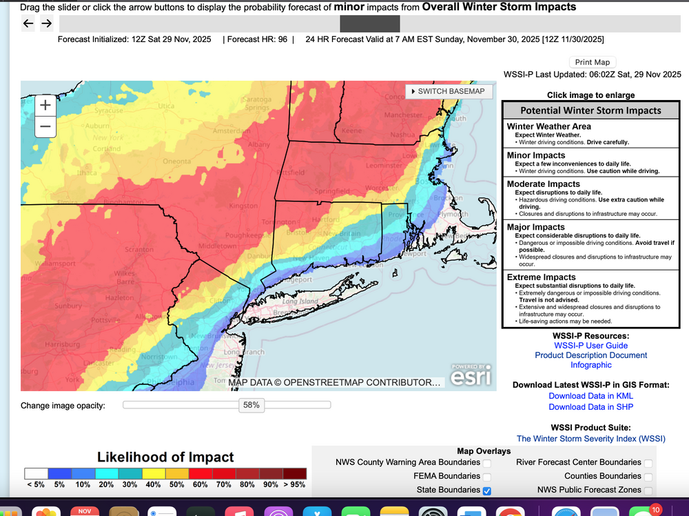
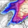
This thread headline looks good based on casual look at info through 06z/29. NYC CP might see their first measurable snow-sleet. Back later today. Ensemble WSSI-P graphic -06z/29, and ensemble prob for 3+" of snow (legend color code probs) hopefully speak for themselves.
-
Central PA Fall Discussions and Obs
Blizzard of 93 replied to ChescoWx's topic in Upstate New York/Pennsylvania
CTP’s forecast discussion is very detailed this morning for the Tuesday potential. -
Central PA Fall Discussions and Obs
pawatch replied to ChescoWx's topic in Upstate New York/Pennsylvania
31 degrees this morning. Wind has died at least. CPT not spilling much about Tuesday yet. -
Came through here as i was putting up some outdoor decorations. Perfect timing to get the season started off right.
-
Pattern is looking good in December. Should be a good month. Threats are already showing up
-

First Winter Storm to kickoff 2025-26 Winter season
MJO812 replied to Baroclinic Zone's topic in New England
-
10 day always looks good
-

First Winter Storm to kickoff 2025-26 Winter season
MJO812 replied to Baroclinic Zone's topic in New England
Okay whatever you say


.thumb.png.0feb2d42d944648a16fc3e5dd9ca1a6d.png)
.thumb.png.b3b1758dd5c0836c0477dc830898daa4.png)

