All Activity
- Past hour
-
I'm not wrong. But feel free to go inspect the environmental damage they have been doing. I'm sure it is all top notch construction too like the bridge that just collapsed that was lauded just a few weeks ago
-
You‘re right about that, this doesn’t seem like a typical La Nina, even though cold decembers do follow the nina pattern. We have three defining features right now: 1) Stratosphere activity 2) MJO activity in phase 7 and/or split forcing 3) Strong -WPO Even with a warm up this month, the models maintain all three features and in conjunction they lead to a cold January based on historical analog matches. If - and a big IF - we lose ALL three features by January (strong SPV, MJO 3-4-5, +WPO), January will torch like 2006 and 2017. But right now, I don’t see us losing any one of these features.
-

December 2025 regional war/obs/disco thread
RUNNAWAYICEBERG replied to Torch Tiger's topic in New England
No one knows. Just have to hope and pray often. It’s all we have, it’s all we have. -
Thank you both for the explanation. I appreciate it!
-

December 2025 regional war/obs/disco thread
Kitz Craver replied to Torch Tiger's topic in New England
Seems we are in a warm/wet, cold/dry type pattern in SNE. 42 and rain tomorrow followed by frigid temps, again. SMH -
Another beautiful drive to Asheville today. Light dusting of snow in Old Fort turned into rime ice on the mountain with the fog and sun breaking through. Wish i could have taken some pictures. As I posted a week or so ago, the pattern is going to likely break down and we are going to warm up for at least a week before Christmas. What happens after that is up in the air but the current colder than normal pattern isn't one that's right for snow for us. We need- 1. A sharper western ridge in the right place- This will lead to energy diving further south to get it where we need it instead of over the Ohio valley. We need it to drop down across the front range. 2. Better southern stream energy. We need a phase to get our best snows and right now the northern stream is squashing the southern stream enough to prevent that. 3. Cold air damming and a 50/50 low to keep it in place. This one might be the most key. The pattern has still been progressive and any highs have been weak or moving away too quickly.
-
12z medium range models and cams have caved to the Euro and GFS. Looks like it could be a solid storm for the northern two thirds of the MSP metro. .
-

December 2025 regional war/obs/disco thread
weatherwiz replied to Torch Tiger's topic in New England
From a common sense perspective that makes sense, but it clearly isn't playing out that way so there must be some sort of meteorological reasoning. We can attribute it to "bad luck" but the atmosphere doesn't work on luck, the atmosphere and weather are governed by principles, physics, etc. The atmosphere is telling us a story and we need to dive deep into the woods to figure out this story. I really hope deep in the modeling and physics worlds, there is work being done to better understand how/why the atmosphere has evolved these last few years...why these faster flow, why models are struggling with it. The only way forecast models can improve on this is if we better understand the process and then taking that knowledge and translating that into mathematical language so computer forecast models can understand it. There clearly is a reason as to why things just aren't working out and we do have some basic ideas and knowledge into this, but hoping for things to play out in favor just because the chances seem to be there isn't meteorologically correct. We are seeing the same thing over and over...fast flow, certain guidance over amplifying in specific time ranges, a whole lot of models guidance swings inside 72 hours...there are reasons for this. -
(002).thumb.png.6e3d9d46bca5fe41aab7a74871dd8af8.png)
Central PA Winter 25/26 Discussion and Obs
ChescoWx replied to MAG5035's topic in Upstate New York/Pennsylvania
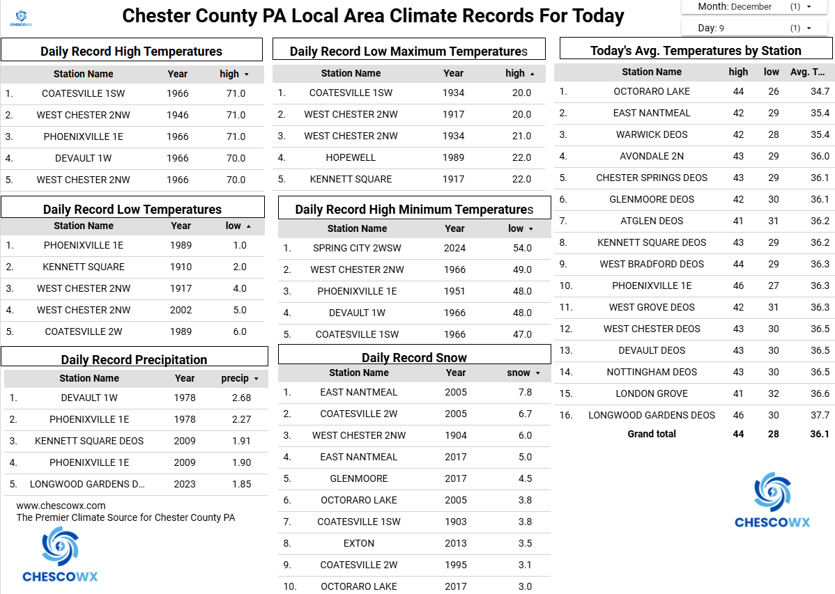
This morning, we saw many valley locations across the area down into the single digits for low. The lowest was the 6.1 at Warwick. This was the coldest morning since late last January when many spots saw below zero temps both the 21st and 22nd of January. We continue to keep well below normal temperatures for the remainder of the week. We do warm up to closer to normal tomorrow which should allow any start of snow or freezing rain to switch to plain rain from SE to NW across the area by late morning. A couple more chances of snow look possible both on Friday night and again on Sunday morning. More frigid temperatures follow any snow potential on Sunday with the coldest day so far this year by next Monday.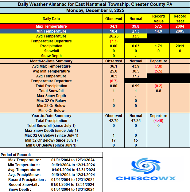

-

Winter 2025-26 Medium/Long Range Discussion
SchaumburgStormer replied to michsnowfreak's topic in Lakes/Ohio Valley
Not hating the "snowpack in place, frequent refreshers" pattern we are in. Feeling pretty good for a white christmas. -
We’re in NAM range for a December event again? This has been awesome from a tracking perspective even if nobody north of Fredericksburg has too much to show for it, lol
-
E PA/NJ/DE Winter 2025-26 Obs/Discussion
ChescoWx replied to LVblizzard's topic in Philadelphia Region
This morning, we saw many valley locations across the area down into the single digits for low. The lowest was the 6.1 at Warwick. This was the coldest morning since late last January when many spots saw below zero temps both the 21st and 22nd of January. We continue to keep well below normal temperatures for the remainder of the week. We do warm up to closer to normal tomorrow which should allow any start of snow or freezing rain to switch to plain rain from SE to NW across the area by late morning. A couple more chances of snow look possible both on Friday night and again on Sunday morning. More frigid temperatures follow any snow potential on Sunday with the coldest day so far this year by next Monday.
-

December 2025 regional war/obs/disco thread
WinterWolf replied to Torch Tiger's topic in New England
I can understand your point….but if we were just at average, there’d be people squawking there isn’t any cold in sight…Decembers suck, bla bla bla…so you can’t win. Now we have the big cold, and it’s literally snowing everywhere but here. Nothing we can do. Grin and bear it. -

Central PA Winter 25/26 Discussion and Obs
Itstrainingtime replied to MAG5035's topic in Upstate New York/Pennsylvania
Yeah, too much cold is; well, too much for legit snow opportunities. We are seeing that play out currently with the bouts of southern snows. It was fascinating watching the snow in VA get shunted south throughout the day yesterday as the arctic air ambushed the state from north to south. -
I rode in -20 to-35 conditions up in the county several years back on back to back days, Once its that cold, You can't tell the difference from -20 to -35.
-
Nam starting to show the little clipper for Friday.
-

December 2025 regional war/obs/disco thread
SouthCoastMA replied to Torch Tiger's topic in New England
I don't even care about other parts of the country. Has no bearing on me, unless its something as egregious as 2010. You just need to keep in mind December climo, and hopefully 12/14 pans out so we are all on track or even above. I think what everyone is sensing is a brewing grincher on the 24th/25th, and the angst and anxiety is starting to bubble over. Lock it in! -
.thumb.jpg.ad3a2e31d30aff035044689b311a0540.jpg)
Winter 2025-26 Medium/Long Range Discussion
nvck replied to michsnowfreak's topic in Lakes/Ohio Valley
looks like 4-6" probable here by tomorrow afternoon, the hrrr finally got with the program and came way south. -
December 2025 regional war/obs/disco thread
WinterWolf replied to Torch Tiger's topic in New England
So what you’re saying is that there are no opportunities for us in SNE, but every other part of the country has opportunities? I mean it’s literally snowing all around us. At some point Paul…it’s hard to escape everything. It could happen, but I don’t think it’s smart to say there aren’t any opportunities, or they(the opportunities) aren’t there. -

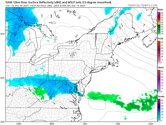
The Monday wintry event potential (12/8/25)
WinstonSalemArlington replied to GaWx's topic in Southeastern States
At 9:02 AM EST, 1 NE Elizabeth City [Pasquotank Co, NC] CO-OP Observer reports Snow of 1.10 Inch -
Honestly, I don't like how cold it has been the past month and a half....At some point, the switch is going to flip and my worry is it will be sometime mid to late January through February during our climo snowfall periods. I would almost rather have this time period be close to average heading into the holidays. Despite what averages show, my firewood burn rate has been at an all time high here, lol...Here is to me being wrong, I am quite ok with that and will be first to call myself out
-
The Monday wintry event potential (12/8/25)
WinstonSalemArlington replied to GaWx's topic in Southeastern States
-
Yeah, you can see where this is headed...they'll squeak into the playoffs and get blown out by the Rams (similar to TB in 2023).
-
Given the proper set up it could have been a SECS, but alas the Pac did not allow it. At that time we did have a - AO and a -NAO. But the PNA was upgly.
-
8.8