All Activity
- Past hour
-
Looks like tomorrow and especially tomorrow night out here on the Allegheny Front will be interesting. We've just been upgraded to a Blizzard Warning.
-
2 times now is been in the teens so far this December. 16 Friday morning and about 17 this morning. Surrounded by water with no wind, that's very very impressive for it only being beginning of December here on the island at the end..
-
That's a girthy shaft for DC..
-
Wait till we lay another 10" the next five days and then it torches till Christmas
-
River ice gone. Geese taking a swim. Hopefully more fun with ice to come this winter.
-
Don't forget to divide by 6
-
If we lose more than 2-3 inches, it will be very frustrating after such a good start to the season. There's so little margin of error here for maintaining appreciable snow cover...even 12-18 hours of milder temps can do a lot of damage. The new wrinkle this season has been melting from below due to warm soil temps. Heaven forbid you try to build a snowpack early in the season...
-
Thanks for the comments. I do think we will get our turn down here in January or early February.
-
1. Where’s “Star” located? 2. No index ever even comes close to guaranteeing anything. That’s nothing new to us. 3, However: The period Dec 3-17, which is prior to the days his maps are showing, is currently looking to end up much colder than normal in the majority of the E US, including a top 3-5 coldest of the last 50 years in many places. That would jibe well with phase 8’s cold E US tendency.
-
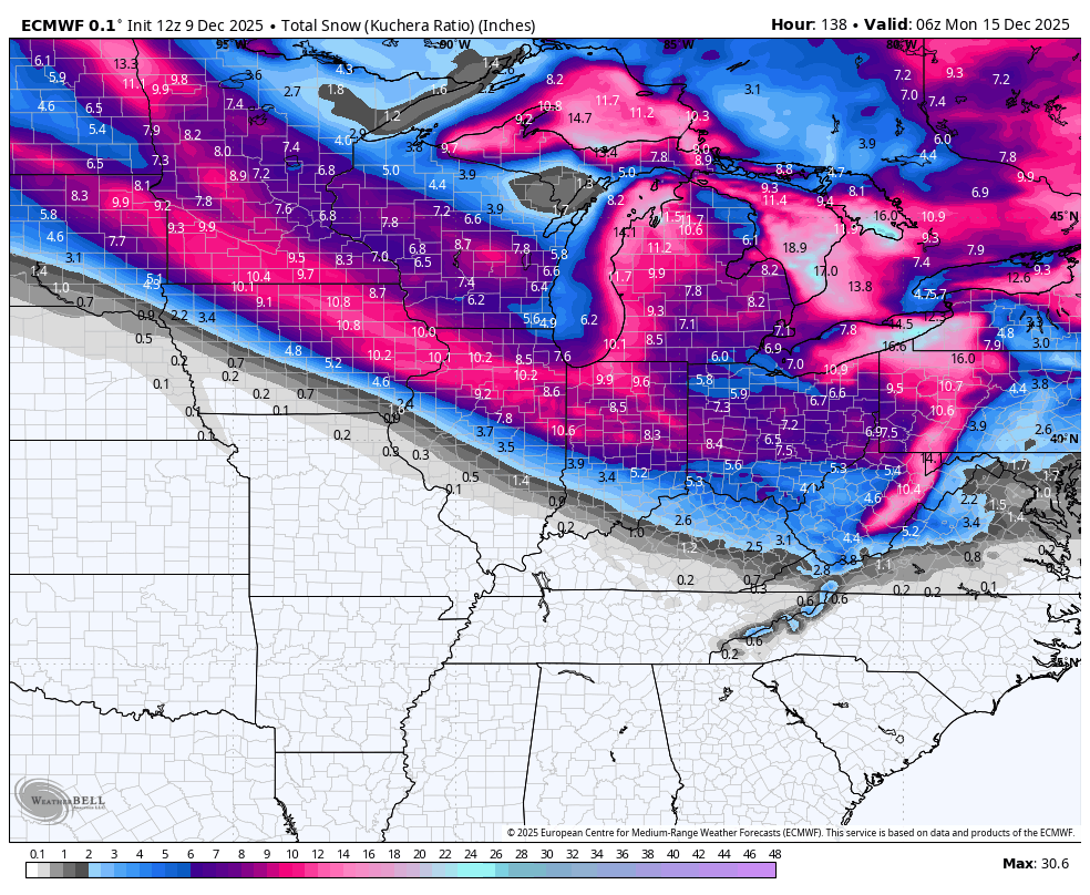
What a cutoff on the euro for the metro area. It seems most often than not, it cuts right through detroit.
-
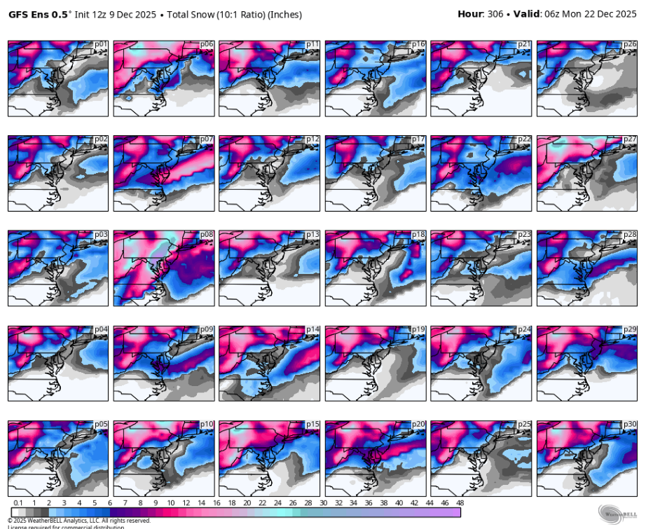
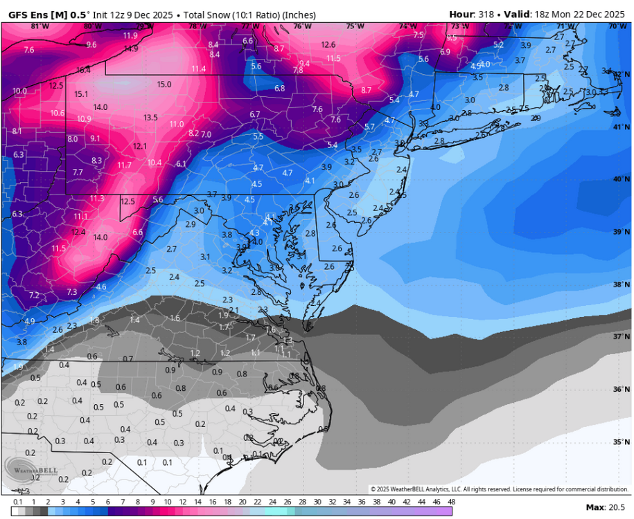
12z GEFS may look very good, but it's heavily skewed by one storm in P8 that drops about 30-40 inches of snow (3-4" QPF, imagine kuchera lol) in the metros lol

-
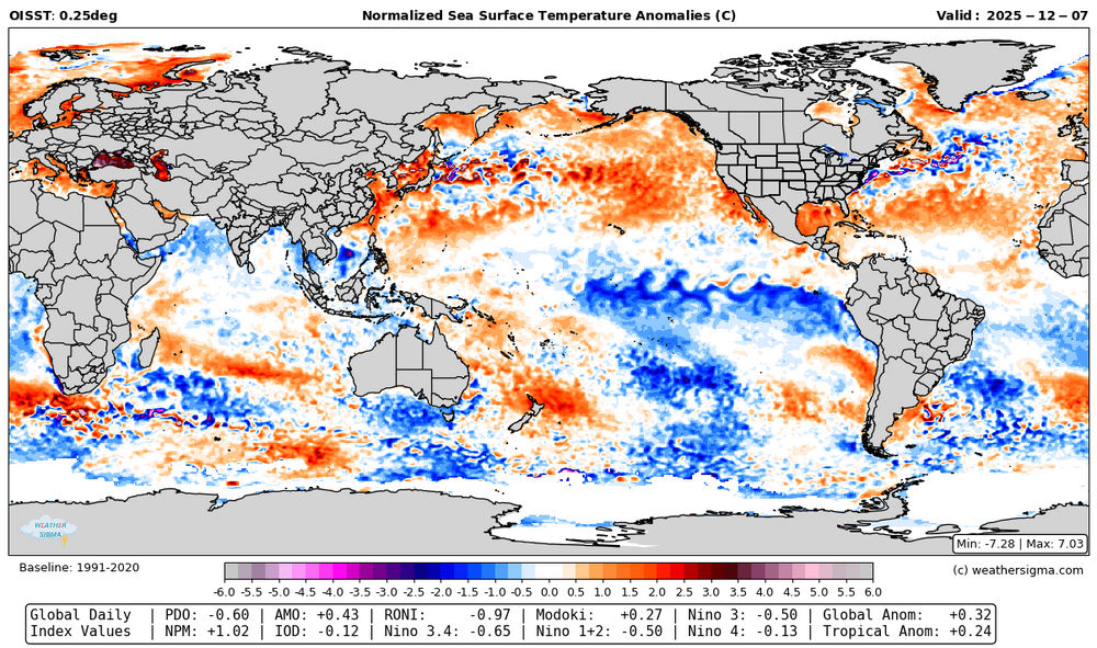
As of the 7th I had the RONI at -0.97.
-
Per Roundy the warm pool near the MC continues to move east. One would think, especially if this continues, the default forcing may shift east as well.
-

Winter 2025-26 Medium/Long Range Discussion
cyclone77 replied to michsnowfreak's topic in Lakes/Ohio Valley
Lock it in. -
Yep, and just 3 runs ago was an epic winter storm.
-
It really wouldn’t take much to amp this up a little more…just need that SPV to drop in behind the speeding shortwave a little earlier/deeper.
-
And the cold is even Westivus for Festivus
-
Expecting some wind driven sprinkles here, followed by a few passing snow showers late tonight. Biggest story here will be 40+mph winds later tonight/tomorrow.
-

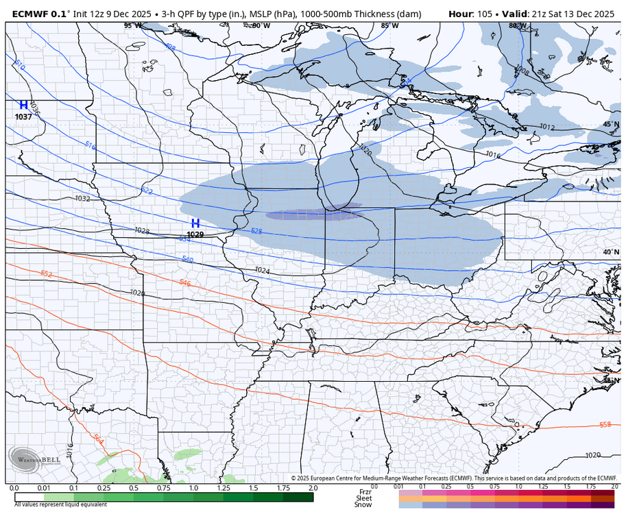
Winter 2025-26 Medium/Long Range Discussion
migratingwx replied to michsnowfreak's topic in Lakes/Ohio Valley
Euro has shifted north from earlier runs for the Friday and Saturday systems. 12z vs 6z bottom 2 maps below


-
thank you!
-

The Monday wintry event potential (12/8/25)
strongwxnc replied to GaWx's topic in Southeastern States
The one with the house is so good. -

December 2025 regional war/obs/disco thread
Kitz Craver replied to Torch Tiger's topic in New England
Lol, I thought that was a deep terminator reference I wasn’t aware of -
We're 2" on Pivotal fwiw. Charlottesville still gets more than that. And you know they will actual get it while ours is iffy. Lol
-
Both years still showing up and idea I shared earlier in this thread if a 30-45 day pronounced cold run is still in play and underway. By the end of Dec (29-31) we will be at 30 days and will see if it extends further Don’t worry about model confusions, Christmas 20-27 will not be a torch
.thumb.JPG.418e8a9a2902ae687ec35ff4bc0e038e.JPG)