All Activity
- Past hour
-

E PA/NJ/DE Autumn 2025 Obs/Discussion
Ralph Wiggum replied to PhiEaglesfan712's topic in Philadelphia Region
Yep. 65F Christmas week is how we usually roll in Ninas round these here parts -
E PA/NJ/DE Autumn 2025 Obs/Discussion
Ralph Wiggum replied to PhiEaglesfan712's topic in Philadelphia Region
Better than what he's usually full of -
I’ll believe it when it happens.
-
Exhilarating
-
I agree. He’s trying to hype it into a KU coastal storm pattern up the east coast. I don’t know what in the heck he’s looking at
-
Woof
-

E PA/NJ/DE Autumn 2025 Obs/Discussion
JTA66 replied to PhiEaglesfan712's topic in Philadelphia Region
I fell for that hook, line & sinker in Dec 1989 -

November 2025 general discussions and probable topic derailings ...
mreaves replied to Typhoon Tip's topic in New England
Well, it is dry from the wood stove. -
I’ll take January 1996 and call it a winter.
-
I was coming on here to mention this. It's showing up in the GEFS mean too.
-

-

November 2025 general discussions and probable topic derailings ...
Torch Tiger replied to Typhoon Tip's topic in New England
Or the famous black hole over favorable blocking regions, which does infact verify, squash eseverything into the SE and we're dry and 40's -

November 2025 general discussions and probable topic derailings ...
CoastalWx replied to Typhoon Tip's topic in New England
Definitely some lotion in the basket there. -
 This gets my vote for post of the year.
 - Today
-

E PA/NJ/DE Autumn 2025 Obs/Discussion
RedSky replied to PhiEaglesfan712's topic in Philadelphia Region
The early cold performing is a Nina trademark I believe lures weenies into believing a special winter is afoot Then bam springtime around the solstice in time for Christmas, like 40/70 thinks -
When it’s clear, we can see the spine from Mansfield to Jay Peak from the porch of camp.


-
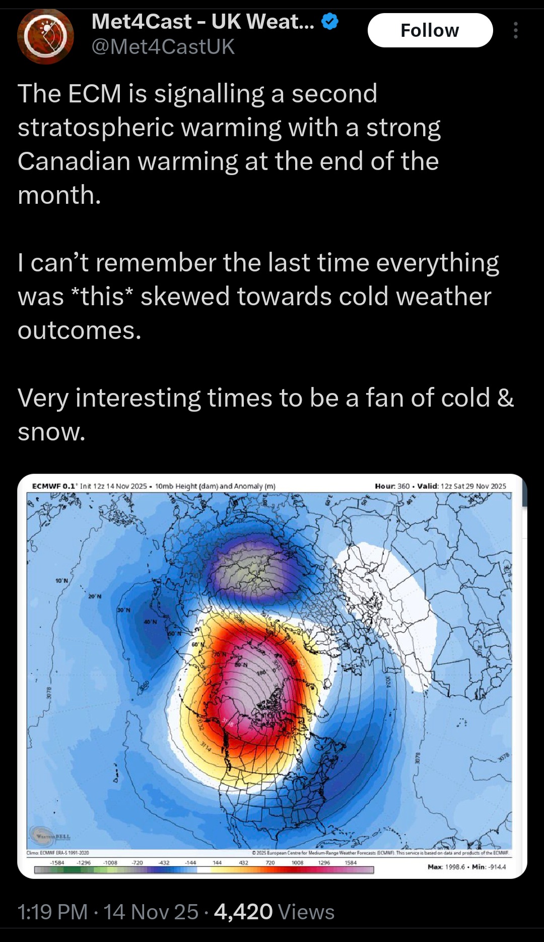
I heard from here the cold air will bleed east. Question is, is this a Siberian event? or North Atlantic event type SSW. As the Siberian event lasts longer the models seem to indicate that it's an Siberian event. I am rather confuse though as the EPS model went from 81 percent predicting a major SSW down to 56 percent last night. This is from Ben Noll on X. @BenNollWeather A sudden stratospheric warming event is forecast to peak around Nov. 25. This will probably disrupt the polar vortex, with Arctic air initially plunging into the west-central United States during late November, accentuating the stormy weather pattern headed for this region. https://x.com/i/status/1989324943415234596 Just two months after a rare stratospheric warming event disrupted the polar vortex above Antarctica, one is poised to do the same above the Arctic before the end of November. Watch the Southern Hemisphere's vortex go from perfectly round to ragged. https://x.com/i/status/1989347337932607567
-
November 2025 general discussions and probable topic derailings ...
mreaves replied to Typhoon Tip's topic in New England
We have Starlink at hunting camp now.
-
Temporarily that has relaxed. But when you have politicians start saying the world will end in 12 years, just 4 years ago, that usually generates the crazies.
-
BWI: 13.3 DCA: 10.5 IAD: 16.7 RIC: 8.8 SBY: 12.0
-
The fatal word of “delay”
-
Wow I didn’t see your numbers - almost exact.
-
Whew. Not often that I see an ensemble look that cold at range. The 12z GEFS looks similar, but with lighter blues. That is most of the continent. 384 map...so proceed with caution.
-
BWI: 11.1” DCA: 8.5” IAD: 12.8” RIC: 7.7” Tiebreaker (SBY): 9.0” mby I’m going 10.5”
-
The SER can probably arrange that. I should be careful about what I joke. Edit: latest ensembles are slower. Otherwise a bird in the hand sooner is always nice. If we get a Jan. thaw maybe February gives a winter encore. Kind of the Carvers Cossgrove hybrid winter. While La Nina is notorious for west first SER, the hemispheric pattern variability should deliver bouts of cold to the Southeast too.