All Activity
- Past hour
-
Looks like we may be dealing with convection for the Wednesday morning commute.
-
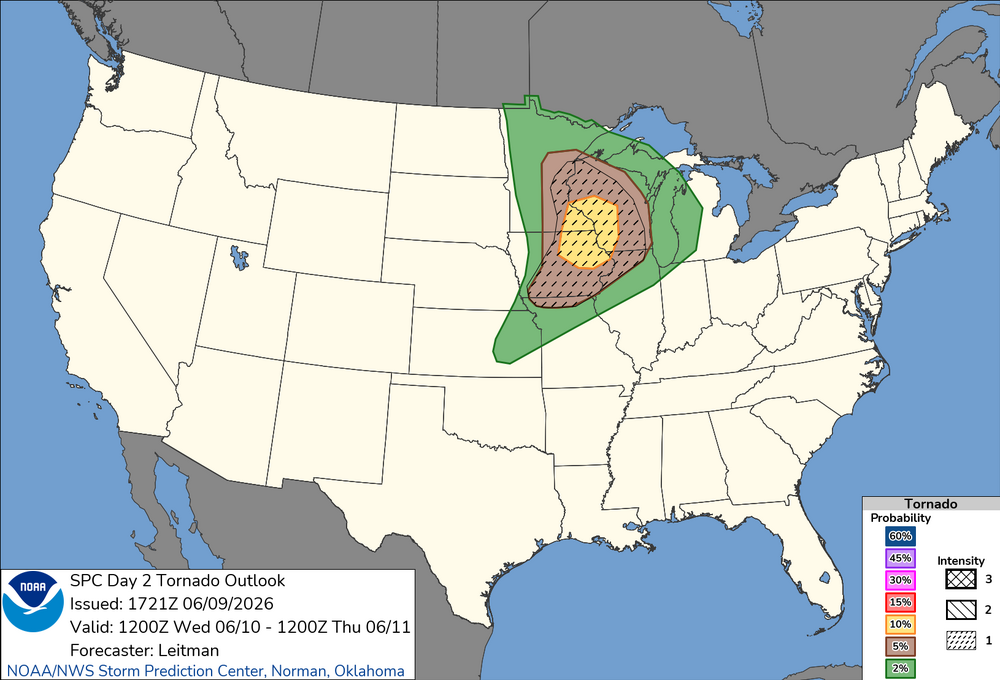
New D2 Tor Outlook. Seems like SW WI always gets the bullseye these days.
-
Means absolutely nothing just like every other long range forecast. Accuracy on those, no matter how they grade themselves, is similar to pin the tail on the donkey
-

Late May/June 2026 Medium/Long Range
Stormchaserchuck1 replied to JenkinsJinkies's topic in Mid Atlantic
Above average temps https://charts.ecmwf.int/products/extended-anomaly-2t?base_time=202511070000&projection=opencharts_north_america&valid_time=202511170000 -
Yeah possible I guess. Starting to get crispy here.
-
Absolutely disgusting storm.
-
I am in favor of daylight visibility at the expense of overall wow (to a point) so I enjoy that some models pop a mid-afternoon line for tomorrow now. Obviously don't want that to end up dudding the whole day or shifting the crosshair for later by accident but if we could sneak a good hit in the afternoon and then another at night that would be baller. Not even to speak of getting another even better chance Thursday to my understanding
-
Day 3 Thu, expect Friday that to push east
-
Yeah, these types of setups always trend towards best instability/theta-e, and that's nearly always going in the wrong direction. unless there's a strong cf squall line, or it's this type of setup but pegged for NNE many days out, forget it
-
The center of the heat looks to settle into the southeast in that period we'll see if it pushes inorth enough nto the NYC region or teters just south towards SNJ / PHL or DC.
-

2026-2027 Super El Nino
snowman19 replied to Stormchaserchuck1's topic in Weather Forecasting and Discussion
The normal peak time for El Niños is almost always November/December. That’s the time (November/December) that the majority of models show this one peaking -
some MCV magic it looks like in eastern MI today, quite a few tor warnings
-
Much will depend on wind direction 6/21 and beyond I think. Ongoing dryness could help the heat over perform. On the other hand the lingering rather strong "cool pool" off the North Atlantic coast could temper the heat, especially along the coast if wind has any onshore component. That cooler than normal water has been persistent. We'll see if it gets beaten back in a meaningful way over the next several weeks. I would have to think it will also lessen the chances of locally intense deluges / significant flash flooding events we have seen scattered across the area over the last several warm seasons. Less moisture added to the atmosphere for our area. That area had been quite warm for the last several summer seasons.
-
what am i looking at?
-
I often feel the same when they are blocking cold air that is chasing moisture! Seriously though, I think one way of explaining the drought would be to note that for the last 9 months it has, with rare exceptions, just been oscillating back and forth between a southeast ridge and a NW flow regime. The NW flow brought us some notable cold stretches last winter but it also kept us bone dry. Now it's just keeping us dry (and intermittently comfortable). We need two solid months of the pattern we had around Memorial day with a Bermuda high well of the coast and a trough to the west but not too close, together pumping gulf moisture up from the south west. And this time please no ridiculous CAD to keep the NC piedmont and west coastal plain stable.
-
Ray would like this storm even though he only got 15” to Kevin’s 40” since you had an inch of glop.
-

2026-2027 Super El Nino
GaWx replied to Stormchaserchuck1's topic in Weather Forecasting and Discussion
I obviously agree with your last sentence as that’s essentially what my quoted 2026 sources said and it’s logical to me, regardless. Regarding the first part, I don’t see why RONI shouldn’t be the preferred way for historical rankings. As far as heat being released into the atmosphere: we know that heat released into atmosphere increases as SSTs rise. Some of that SST rise is from El Niño (essentially RONI) and some is due to continued GW from CC (essentially ONI less RONI more or less). In the upcoming case, a huge amount will be imparted by what has a good chance to be a record breaking RONI or at least close to a record. All ENSO regions are looking to be quite warm and thus will contribute a large amount of heat. That’s different from a severely E based that may not contribute as much heat because of the other ENSO regions not being as warm. -
Rufus looked a little better in E MA/NH…a little trigger along the theta-e grad and outflow enhanced seabreeze pushing westward. I’m just interested in rain though.
-
Temps underperforming a little so far today?
-
I've managed a few showers so far today. Heavy when they start but very short lived.
- Today
-

2026 Mid-Atlantic Severe Storm General Discussion
Eskimo Joe replied to Kmlwx's topic in Mid Atlantic
Co-sign. Would favor the higher elevations along and west of I-81 where updrafts can get a boost from the terrain, or neat the bay where a bay breeze front can boost some forcing. -
It’s too bad it’s so blocky at 500 because that was a good trajectory for southern New England in general. We fucking suck.
-
I would permanently delete my account and rip up my degree if that storm happened in my lifetime.
-
Records: Highs: EWR: 102 (2011) NYC: 97 (1933) LGA: 99 (2008) JFK: 96 (1984) Lows: EWR: 47 (1957) NYC: 47 (1930) LGA: 59 (1980) JFK: 48 (1980) Historical: 1853: Worcester, Massachusetts: A tornado strikes the town of Worcester killing 94 persons. The tornado cuts a path as much as a mile wide as it spins through 46 miles of Worcester County. Along the way it destroys steel towers designed to withstand winds of 375 mph. (Ref. WxDoctor) 1874:The highest maximum temperature ever recorded in June in Washington, DC was 102 °F. (Ref. Washington Weather Records - KDCA) 1953 - A tornado hit the town of Worcester MA killing ninety persons. The northeastern states usually remain free of destructive tornadoes, however in this case a low pressure system, responsible for producing severe thunderstorms in Michigan and Ohio the previous day, brought severe weather to New Hampshire and central Massachusetts. The tornado, up to a mile in width at times, tracked 46 miles through Worcester County. It mangled steel towers built to withstand winds of 375 mph. Debris from the tornado fell in the Boston area, and adjacent Atlantic Ocea. (David Ludlum) (The Weather Channel) 1955: April-like temperatures persisted at Wichita Falls, TX. Morning low temperatures each day from the 9th through the 12th fell into the low to mid 50s, as much as 20 degrees below normal. These temperatures of 56°, 51°, 52°, and 55° respectively, remain record lows for their dates. Las Vegas, NV recorded a high temperature of 111°, setting a daily record. (Ref. Wilson Wx. History) 1966: Hurricane Alma made landfall over the eastern Florida panhandle becoming the earliest hurricane to make landfall on the United States mainland. 1971: The tornado that struck the town of Gruver in the Texas Panhandle on this date is believed to be the widest tornado in U.S. history with an average path width of 2,500 yards. At times, the monster storm was over two miles wide. (Ref. Wilson Wx. History) 1972 - A cloudburst along the eastern slopes of the Black Hills of South Dakota produced as much as 14 inches of rain resulting in the Rapid City flash flood disaster. The rains, which fell in about four hours time, caused the Canyon Lake Dam to collapse. A wall of water swept through the city drowning 237 persons, and causing more than 100 million dollars property damage. (David Ludlum) 1974: This was the start of the shortest seasonal snow free period on record at Denver, CO. The 94 days began with the last snow of the season was on the previous day (a trace) and the first snow of the next season occurred on September 11th (a trace). (Ref. Wilson Wx. History) 1975: Thunderstorms that developed over the Springfield, MO. area dropped 3.62 inches of rainfall in one hour. This was the greatest hourly rainfall rate recorded for Springfield. (Ref. Wilson Wx. History) 1987 - Lightning struck Tire Mountain near Denver CO, destroying two million tires out of a huge pile of six million tires. Thunderstorms spawned three tornadoes around Denver, and a man was killed at Conifer CO when strong thunderstorm winds lifted up a porch and dropped it on him. A thunderstorm near Compton MD produced two inch hail, and high winds which destroyed twenty barns and ten houses injuring five persons. (Storm Data) (The National Weather Summary) 1988 - Thunderstorms produced severe weather from North Carolina to the Central Gulf Coast Region. Hail in North Carolina caused more than five million dollars damage to property, and more than sixty million dollars damage to crops. Hail three and a half inches in diameter was reported at New Bern NC. Thunderstorms in the Central High Plains produced eighteen inches of hail at Fountain CO. The temperature at Del Rio TX soared to an all-time record high of 112 degrees. (The National Weather Summary) (Storm Data) 1989 - Severe weather abated for a date, however, showers and thunderstorms continued to drench the eastern U.S. with torrential rains. Milton, FL, was deluged with 15.47 inches in 24 hours. Record heat and prolonged drought in south central Texas left salt deposits on power lines and insulators near the coast, and when nighttime dew caused arcing, the city of Brownsville was plunged into darkness. (The National Weather Summary) 1991: A tornado struck the town of Minatare, NE, just southeast of Scottsbluff. 20 homes were destroyed with 30 others damaged along its 4 mile track. Damage estimates exceeded $2.5 million dollars. (Ref. Wilson Wx. History) 1993: Lightning struck a US Air Boeing 737 parked overnight at the Buffalo International Airport in New York. The lightning traveled through the plane to the runway and exploded the concrete runway at the three points of the landing gear. The flying concrete debris caused damage to the fuselage and winds of the plane. The 737 had to be ferried out for repairs. In addition to the damage to the plane and runway, power generators connected to the plane overnight were shorted and blown out. (Ref. Wilson Wx. History) 2003: Q: What's the highest dew point ever recorded? In the USA, the highest dew points (above 80°F) occur near the Gulf of Mexico and in parts of the upper Mississippi Valley. Very high dew points are often found near shallow, subtropical seas. Dhahran, Saudi Arabia, on the Persian Gulf, recorded a dew point of 95°F on July 8, 2003. (Answered by meteorologist Bob Henson, a writer at the University Corporation for Atmospheric Research and the author of The Rough Guide to Weather, June 9, 2005.) 2004: A massive hailstorm with hailstones up to 2.25 inches in diameter struck the south sections of the Denver, CO metropolitan area. Combined damage to homes and automobiles, not including commercial buildings, was estimated at $146.5 million dollars, the 4th costliest insurance disaster in the state's history. (Ref. Wilson Wx. History) 2008 June 7 - 9 , New York, New York: New York City set record high temperatures for three days running: 96 °F, 96 °F, and 99 °F. (Ref. WxDoctor)
-

2026-2027 Super El Nino
Yanksfan replied to Stormchaserchuck1's topic in Weather Forecasting and Discussion
If we end up going super so be it. More important is when does it peak and start to fall off as far as winter is concerned.


.thumb.gif.f92b16c631a1d15d405ed77b33f0710d.gif)
.thumb.jpg.ad3a2e31d30aff035044689b311a0540.jpg)


