All Activity
- Past hour
-

“Cory’s in NYC! Let’s HECS!” Feb. 22-24 Disco
Damage In Tolland replied to TheSnowman's topic in New England
No you are mistaken. Dad has always said S Wey . -
Maybe at the very start there are a few raindrops or mix on the coast? There’s no concern about it cutting down accums.
-
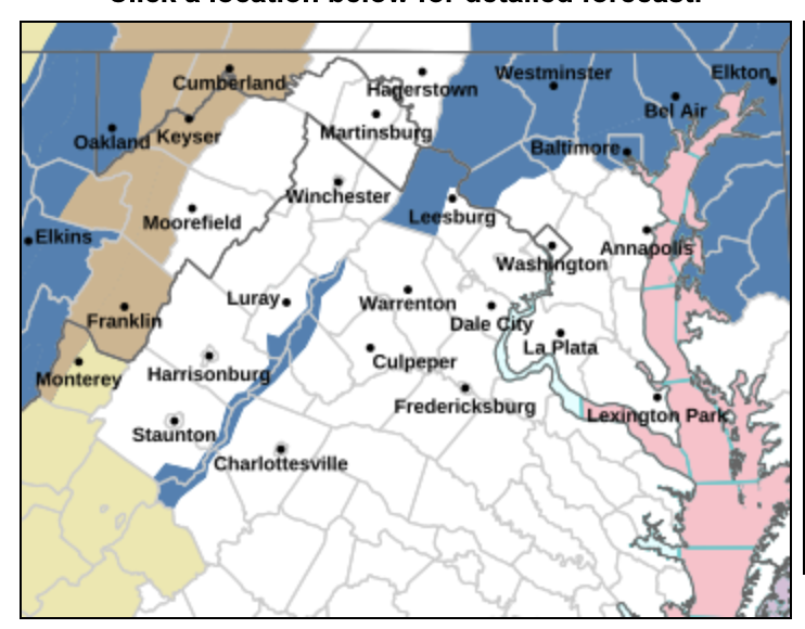
I understand the watch for NE MD and the counties bordering Mason-Dixon... it was the Western Loudoun/Montgomery/Howard additions.
-
Baltimore officially under the gun.
-
Yeah pretty surprised they did not put up a watch regionwide
-
For my own greedy purposes I'd like to see the sfc end up to the south of KBID / KMVY by about 50 miles. Most favorable for inland spots of NNJ.
-

February 22-23 Storm Thread/OBS
coastal front replied to Mikeymac5306's topic in Philadelphia Region
This is only through 7am Monday. In theory it could be higher. Speechless…. -
37 at home, 34 at work. we ‘ll need some cooling for higher amounts. meanwhile, we sit under clouds
-
There's a 10%, 90%, and best guess, along with many maps for % chance of getting more than a certain number of inches of snow, all at https://www.weather.gov/phi/winter
-
First weenie flakes just starting now.
-
We don’t have the best elevation and we often smoke exhaust for big coastal, but I do love Greenfield in an SWFE NW MA is built to thrive in these latitude set ups.
-
But at the start temps will be above freezing for sure
-

“Cory’s in NYC! Let’s HECS!” Feb. 22-24 Disco
HoarfrostHubb replied to TheSnowman's topic in New England

-
Yeah, most events jackpot either east of NYC or to the west. January 2016 and 2006 were the rare events that maxed out right across NYC and the boroughs. The heaviest snow for any given event usually ends up in the interior or across Long Island.
-
Thats a weird looking watch contour... but i guess they are going elevation for now
-
I don’t mean to be a Debbie downer here. But (in strictly Laymans terms)isn’t there a good chance that this is going to end up being a bunch of rain because the temperature is not supposed to fall below freezing during the entire event? Having a hard time buying this one.
-
-

Central PA Winter 25/26 Discussion and Obs
Jsauss replied to MAG5035's topic in Upstate New York/Pennsylvania
no snow for me and @Blizzard of 93 -
URGENT - WINTER WEATHER MESSAGE National Weather Service Baltimore MD/Washington DC 231 PM EST Fri Feb 20 2026 MDZ004>006-008-011-503-505-507-508-VAZ505-210345- /O.EXB.KLWX.WS.A.0003.260222T2000Z-260223T1500Z/ Frederick MD-Carroll-Northern Baltimore-Cecil-Southern Baltimore- Northwest Montgomery-Northwest Howard-Northwest Harford-Southeast Harford-Western Loudoun- 231 PM EST Fri Feb 20 2026 ...WINTER STORM WATCH IN EFFECT FROM SUNDAY AFTERNOON THROUGH MONDAY MORNING... * WHAT...Heavy snow possible. Total snow accumulations 5 inches or more are possible. * WHERE...Portions of central, northeast, and northern Maryland and northern Virginia. * WHEN...From Sunday afternoon through Monday morning. Snow may begin Sunday morning, but the heaviest snow and coldest temperatures are most likely late Sunday afternoon through early Monday morning. * IMPACTS...Travel could be very difficult, especially Sunday night into Monday morning. The hazardous conditions could impact the Monday morning commute. PRECAUTIONARY/PREPAREDNESS ACTIONS...
-
North wey we live in
-
Are there other percentile maps 50%25% ETC? Thanks in advance.
-
What? If you have the rates you will get dynamic cooling. Location has nothing to do with it. Getting the rates could be the issue depending on what plays out. If you get under a coastal CCB you're going to get nuked with snow heavy enough that it's gonna accumulate whether you like it or not. The question is whether or not it will get west enough and how strong it will be.
-
johnnycakes? (throw back to the Sopranos) saw a few flakes 1/2 hour ago, otherwise not much going on here
-
March 2001 shifted like 200 miles north at the last minute. No chance of that happening this time around. A miss to the east is the bust scenario in this case.
-
I like that look to get heavier snows further N and W into NNJ.


.thumb.png.4150b06c63a21f61052e47a612bf1818.png)


