All Activity
- Past hour
-
It's unfortunate happenstance that some spots further south are on a bit of a "run" (though I doubt if you asked the SE thread folks, they'd think they've been on a heater) but in the greater timescale of recorded meteorological history the streak you refer to is a blip. It'll average back out in the averages eventually.
-
CME is about to hit within 20-30 minutes as of this post.
-
CME is about to hit within 20-30 minutes as of this post.
-
(002).thumb.png.6e3d9d46bca5fe41aab7a74871dd8af8.png)
Central PA Fall Discussions and Obs
ChescoWx replied to ChescoWx's topic in Upstate New York/Pennsylvania
I have continued to update the Chester County Weather website and have now completed and added a listing of the largest Chester County snowstorms across the 7 months of the year - October through April that we have recorded snow events. https://chescowx.com/top-snowfalls-by-month/ this includes the 2nd largest snowstorm in County history that occurred in March 1958 when between 19" to as much as 50" of snow fell across Chester and SE Berks Counties. See below. -
E PA/NJ/DE Autumn 2025 Obs/Discussion
ChescoWx replied to PhiEaglesfan712's topic in Philadelphia Region
I have continued to update the Chester County Weather website and have now completed and added a listing of the largest Chester County snowstorms across the 7 months of the year - October through April that we have recorded snow events. https://chescowx.com/top-snowfalls-by-month/ this includes the 2nd largest snowstorm in County history that occurred in March 1958 when between 19" to as much as 50" of snow fell across Chester and SE Berks Counties. See below. -

November 2025 general discussions and probable topic derailings ...
weatherwiz replied to Typhoon Tip's topic in New England
I really hope something changes moving through December. But I hope this really isn't another year of major wave breaking along the West Coast that pumps up a massive ridge across the eastern third of the country and we just see cutting/weakening storms as the approaching trough lifts out then we get several days of cold/dry on the backside of the systems and just rinse and repeat as the next wave break occurs and the next ridge builds. I think a month or two ago I made some comments that I didn't think ENSO will be a big player in the overall regime but kind of looking ahead...I actually wonder if (regardless of what ENSO indices show) the hemispheric pattern this winter may be reflective of what you would see in a stronger Nina event. -
Link doesn't work.
-
So are we gonna have an epic winter with big snows or is it gonna be cold, dry and windy? That's the question.
-
We've gotta get old fashioned sustained blocking back. If so, those averages will increase.
-
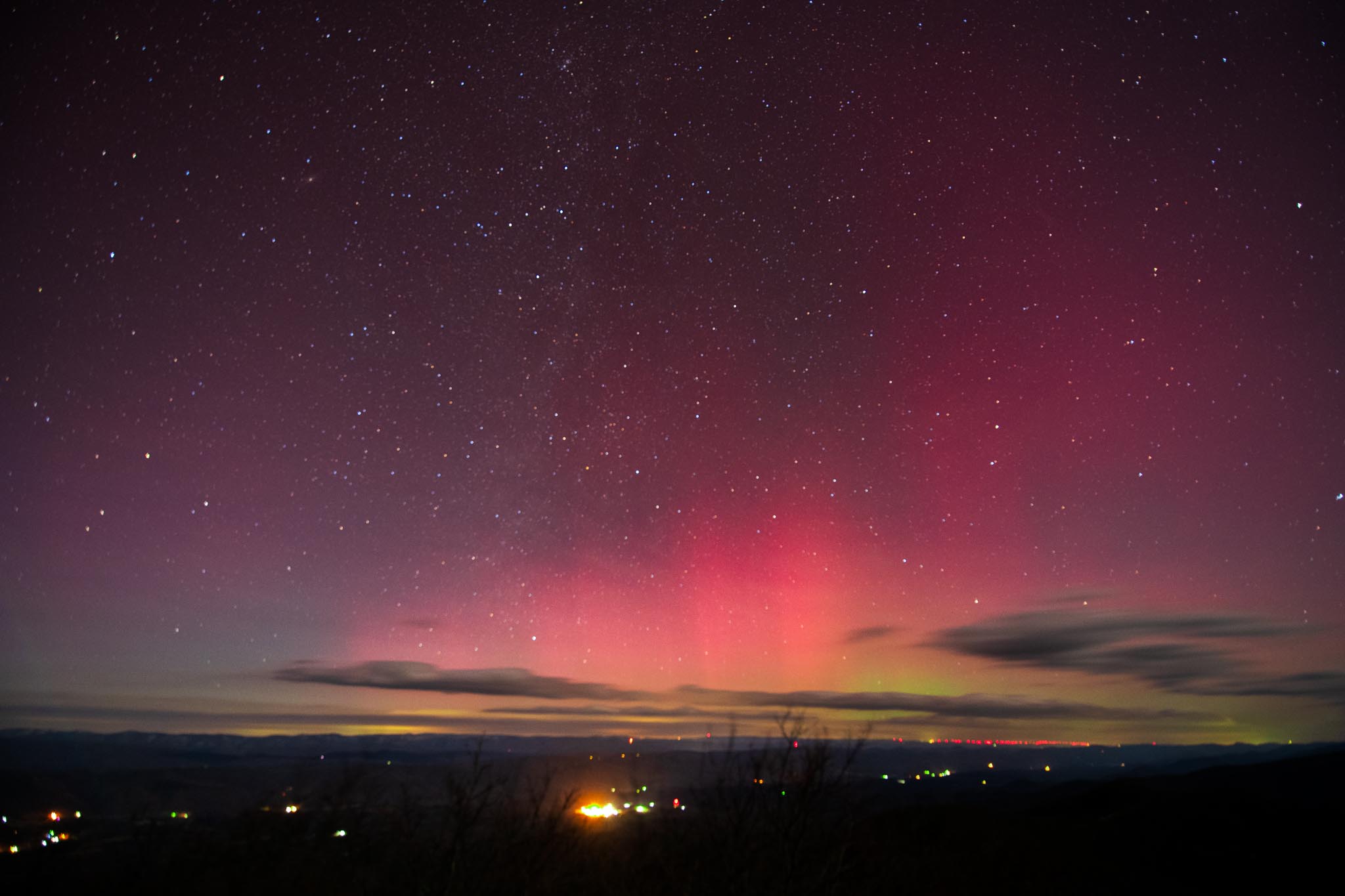
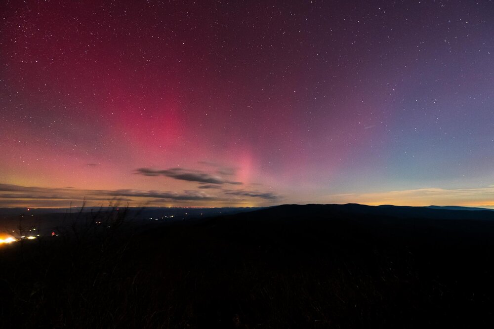
Do all of that and that’s how to get a shot like these! (From WV/VA border and 4000+ ft at 12:30am)

-
Maybe, Kammerer is right
-

November 2025 general discussions and probable topic derailings ...
WinterWolf replied to Typhoon Tip's topic in New England
Lol. The Sanfrancisco treat. -
Maybe, Doug Kammerer is right
-
82%. Nice.
-
As a photographer enthusiast all you really need is 1. Tripod 2. 10 second shutter 3. Lowest f stop possible lens (2.8 is good) 4. 1600-3200 iso 5. preemptively use manual focus on a distant light to ensure your focus is good! Happy photographing!
-
 Would that be because of the government shutdown? I'm frankly impressed that so many services are still functioning, the Weather Service in particular.
 -
I'm sitting here trying how to use my 10-year old DSLR camera that has been on the shelf for years because iPhones are easy. F-stops, ISO, etc.
-
This may be the person you’re referring to in Henniker, but we had a sick heron on our property about 10 years ago and we took it to her and about two weeks later we picked the bird up completely rehab and re-released it on our pond. She was great at least with our bird. But I think she specializes in birds And I don’t know her name.
-

2025-2026 ENSO
brooklynwx99 replied to 40/70 Benchmark's topic in Weather Forecasting and Discussion
what do you think the answer to those questions are -
Yes, indeed. Couple comments on the AMS journal article I linked to. The authors cite the prior record statewide storm total snowfall as 42.0" at Gratiot, Ohio, from April 19-22, 1901. 42.0" of snow was also observed by the observer at Canton, Ohio, from that same storm, although it looks like those observations have never been digitized. Additionally, 44.0" was reported at Steubenville, Ohio, from November 24-29, 1950, during the Great Appalachian Storm of 1950, which is probably the true record besides this 1996 LES storm. Interestingly, they conclude that a snow depth of 48" reported by a nearby observer was incorrect and inflated. One would think the more reasonable conclusion is the snowfall amounts were underreported due to the infrequency of measurements. Also, as further evidence of inflation, the author points out that only 1" remained on the ground at the end of the month at that site, while 6" was observed at the other site. However, this could easily be explained by one location being in a sunnier and more exposed location, or by the other spot receiving more snow the remainder of the month. It sounds like another 7 or 8" fell there even after this storm. Either way, that is an impressive duration of snow cover for the month of November - even for the "snow belt" of Ohio.
-
South trend came 12z GFS but now it’s too far south and all rain central/southern VA
-
HRRR/RAP making me inclined to make somewhere in Loudoun or far-western FFX the target. MD not looking amazing
-
If it is behind the trade off is it may be less intense but we shall see. Either way yes we need a south Bz.
-
There's one near me Brian in Cape Neddick, don't know much about it though.