All Activity
- Past hour
-
Shades of? https://www.weather.gov/lot/2014_06_30_SevereStorms
-
 This is especially ironic coming from someone who normally claims NOAA’s modern records are bogus, adjusted, contaminated, or otherwise untrustworthy. But a lone 105°F reading from a high-elevation northern interior New York site in 1919, with surrounding stations reporting 88–94°F on the same date, is suddenly sacred scripture? And that was literally the only substantive change I made. The rest of the map is from Martz’s own website, just reassembled to show the most recent occurrence of a given high, with a couple of corrections for omissions (Maryland & NC in 2012) and updated to include 2025's record highs(map ends in 2024). Martz himself excludes
 -
The HRRR is top tier for tomorrow around here, projecting 3 rounds of back-back-back severe clusters locally.
-

2026 Mid-Atlantic Severe Storm General Discussion
Eskimo Joe replied to Kmlwx's topic in Mid Atlantic
I would favor Friday for more organized severe weather. Thursday gives the all hat no cattle impression. -
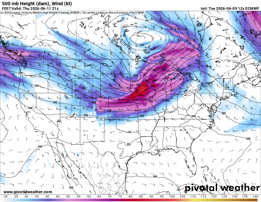
That is quite a potent shortwave on the 12z Euro for Thursday with a 90+ kt 500 mb max, especially for June. Morning convection will rule the roost as usual, but I would expect a pretty widespread and potentially significant severe event given the magnitude of the flow overlapping strong instability.

-
Funny last night for no reason I was thinking about derechos and the pronunciation It is written
-
I'm in that camp too unless it migrates west quicker and becomes more of a Modoki Nino
-
12z NAM really bakes the Carolinas and even south of RIC on Friday. Several locations make a run at 100°.
-
It is a blister of a day out there, the humidity after this dry spell feels like the sky is drubbing you! 29C/84F with a humidex of 38 likely, wow. I foresaw a delay of possible storms til after 5pm and TWN revised their rain from 25-30 to 5mm in line with WUN.
-

E PA/NJ/DE Spring 2026 Obs/Discussion
LVblizzard replied to PhiEaglesfan712's topic in Philadelphia Region
SPC has us in a marginal risk on Thursday and a slight risk on Friday. Wouldn’t be surprised to see an upgrade for Thursday in future outlooks. - Today
-
Getting excited for this one. I wish I didn't have to work because I'll be stuck in the newsroom/producer booth, but I'll be watching the storms on radar and through weather cameras. There are worse ways to make a living.
-
Man...rooting for stuff here in MD realllly sucks. I mean we can't get a win anywhere. Can't get a good snow (and now facing a torchy niño which might spawn another nina the following year). Ravens have disappointed--though we don't know about this year with the new regime. Orioles keep finding a way to be close to good but not quite. We have just been the unluckiest area for snow and sports since 2016. I mean we have not gotten a single win with anything that could bring us more joy. C'mon man I need something here, lol
-

2026-2027 Super El Nino
GaWx replied to Stormchaserchuck1's topic in Weather Forecasting and Discussion
For the first time in awhile, Nino 3.4 didn’t warm per OISST. Instead, there was a notable cooling of 0.065C (see image below). After such an impressively strong warming since May 31st, this isn’t surprising. To me it is just El Niño taking a temporary breather of sorts. Ups and downs always happen. It’s still up at ~+1.0 RONI/+1.5 ONI equivalent snapshot. I expect the next round of notable warming to be later this month or in early July at the latest, especially if the -SOI persists, as that’s what ENSO models are suggesting.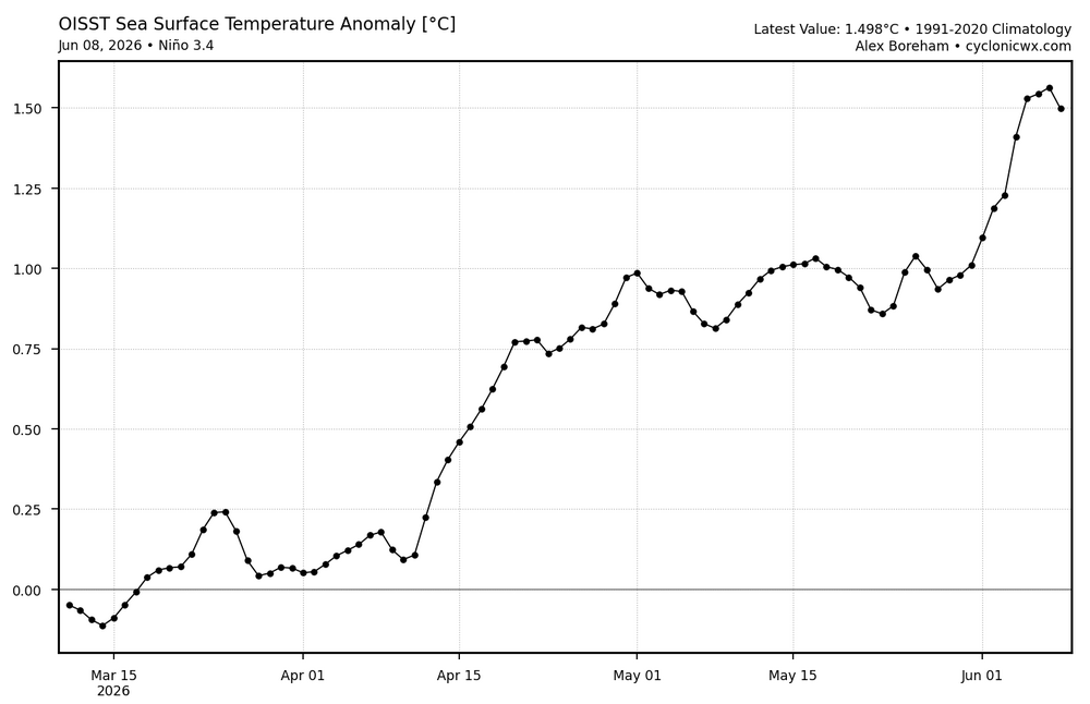
-

2026-2027 Super El Nino
snowman19 replied to Stormchaserchuck1's topic in Weather Forecasting and Discussion
I agree. At the very least, I think we tie the record RONI and ONI, with a very good chance that we break the records on both of them. I also think this one stays east-based (maybe not as east-based as 1997-98 and 1982-83….several more months to go…..verdict still out obviously) but east-based none the less -
Just noticed that. Looks potentially soggy for much of DC-Balt around 7am
-
The one thing that can elevate a normally garden variety threat would be if the outflow from storms can really make a robust cold pool that propagates off the terrain and gusts out. I don't think we'll have a solid handle on how the day(s) will play out until each one is on top of us.
-
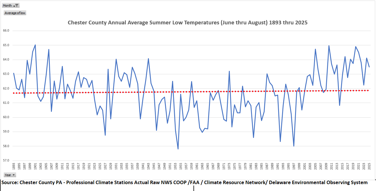
(002).thumb.png.6e3d9d46bca5fe41aab7a74871dd8af8.png) There are some who believe our nightime lows are getting warmer during the summer months. The actual data sees no such warming - almost flat since 1893!
There are some who believe our nightime lows are getting warmer during the summer months. The actual data sees no such warming - almost flat since 1893!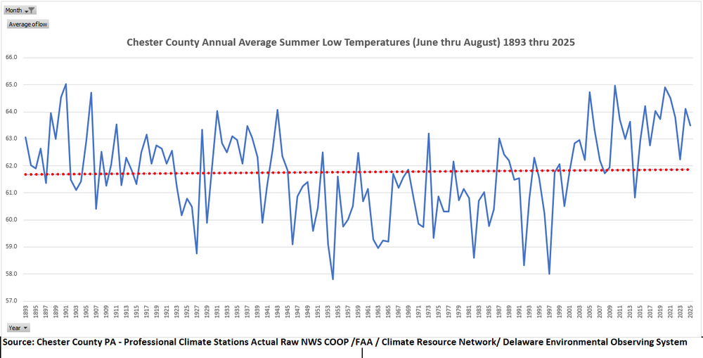
-
Central PA Summer 2026 Discussion/Obs Thread
Eskimo Joe replied to Voyager's topic in Upstate New York/Pennsylvania
Yinzer Alley™ go brrr -

2026-2027 Super El Nino
PhiEaglesfan712 replied to Stormchaserchuck1's topic in Weather Forecasting and Discussion
Yeah, almost all el ninos do that, with the obvious exception of 1986-88 (which peaked in between seasons, in the summer of 87). However, the earlier the peak/fall off, the more likely for a strong la nina the following year. Just look at 1973, and the aforementioned 1988, for example. Those years got very close to, or even breached, -2.0C. -

Winter cancelled/uncancelled banter 25/26
LongBeachSurfFreak replied to Rjay's topic in New York City Metro
I mean it’s a pretty easy forecast. This is a close the blinds winter for snow lovers. Not every super times a big storm with cold like 82/83 and 15/16. Without that it’s warm pac air with a few modified continental polar cool shots. . -
Doesn't appear to be a very hot summer on tap.
-
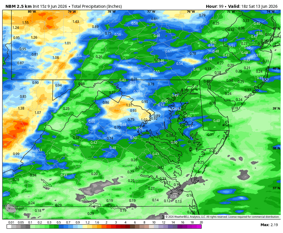
WB 15Z NBM thru day 4
-
Totally agree but he's usually looking for cold/snow so interesting he thinks warm and snowless
-
Get ready to Day 3 Moderate?