All Activity
- Past hour
-

July 2025 Obs/Disco ... possible historic month for heat
Damage In Tolland replied to Typhoon Tip's topic in New England
Dew already back to 61. Can’t keep em down long -

2025 Atlantic Hurricane Season
BarryStantonGBP replied to BarryStantonGBP's topic in Tropical Headquarters
Of course every day is a sunny day for this fella -
.09" of rain since midnight.
-

July 2025 Obs/Disco ... possible historic month for heat
Typhoon Tip replied to Typhoon Tip's topic in New England
I believe we are at 3 heat waves official on the summer when now including last week? I wasn't here last week but I saw two or three back-to-back days on NWS main page with Advisory graphics. Mustn't of been too bad otherwise there'd have been more news coverage. Heat of some sort is slated synoptically for later this week. This is impressive in the teleconnectors as a short but potent heat burst potential, however... the operational guidance are interestingly suppressed with the polar jet relative to normal latitude ...draping a fast ablative flow from Montana to Nove Scotia with ample S/W's rippling along. If so, would to spark daily MCS that turn right most likely ... fabricating boundaries that disrupt what would otherwise be something more similar to the heat wave we experienced around the end of June. This is nuance in nature and wouldn't really be indicative in the teleconnector spread, which is a static -PNA through late next weekend, within which there's an impressive negative EPO interval. This shows up as cascading/digging along the Pac N/W of the continent...sending an impressive + height signal E of 100 W. The fast flow across S Canada limiting the ridge's ability to balloon to 50 N is what's stopping the heat ( potentially...) from getting E of the Lakes. It can happen and satisfy/fit inside of the -PNA/-EPO circumstance. So we'll have to see. Right now the highest heat looks to be packed back W-S of here, with perhaps more marginal heat wave conditions evolving NE of Pittsburgh - which can change.. -

2025 Short Range Severe Weather Discussion
A-L-E-K replied to Chicago Storm's topic in Lakes/Ohio Valley
Rain and a miss south -

July 2025 Obs/Disco ... possible historic month for heat
Torch Tiger replied to Typhoon Tip's topic in New England
always wanted to move south but the south moved here. sweet -

July 2025 Obs/Disco ... possible historic month for heat
kdxken replied to Typhoon Tip's topic in New England
74° / 52° at the absolute peak of climo. We take... -
July 2025 Obs/Disco ... possible historic month for heat
Torch Tiger replied to Typhoon Tip's topic in New England
very impressive and telling -

2025-2026 ENSO
40/70 Benchmark replied to 40/70 Benchmark's topic in Weather Forecasting and Discussion
Beat ya for once lol -
The Orioles have been outscored 28-2 in their last 3 games. Football season can't come fast enough.
-
July 2025 Obs/Disco ... possible historic month for heat
Typhoon Tip replied to Typhoon Tip's topic in New England
-
Its hard to judge tone/intent over a message board. I would suggest if you are just looking for a friendly conversation, not to use "???????????" and '.............." when asking a question or making a comment. Maybe instead of "Wheres the rain????????????" it could have been "Hey I noticed the last several days we were forecast to get a ton of rain, but I haven't seen much at all, what do you think is the reason?" Back on topic - Boy has it been wet in Western Maryland. Barely got any swimming/lake time in over the last couple days. Super humid, mostly cloudy and constant rain showers rolling through. Some of which were HEAVY downpours. Talking with some locals and they don't remember a wet stretch like this in quite some time. Making outdoor construction/projects difficult because the ground just never dries out. We drove home late last night and it was crazy foggy in certain spots and ran into a pop up rain storm when we arrived back in EC, I kinda felt like Eeyore lol. Looking forward to Monday and a trip to Hershey park!

-
July 2025 Obs/Disco ... possible historic month for heat
Damage In Tolland replied to Typhoon Tip's topic in New England
Sorry to hear of their passing . That is a rough year. At least you can now get back on the coming torch middle of next week and beyond -

July 2025 Obs/Disco ... possible historic month for heat
dendrite replied to Typhoon Tip's topic in New England
Hrm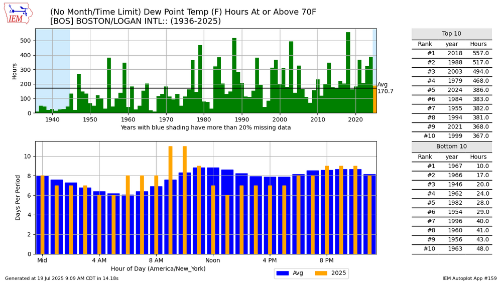
-
July 2025 Obs/Disco ... possible historic month for heat
Typhoon Tip replied to Typhoon Tip's topic in New England
yeah this is it. -the instagram meme i saw too. veracity notwithstanding. -
July 2025 Obs/Disco ... possible historic month for heat
Torch Tiger replied to Typhoon Tip's topic in New England
acatt Boston has registered 120 hours with a dew point of 70 degrees or higher through July 15 – over two times as many hours compared to average, according to data compiled by Iowa State University. -
July 2025 Obs/Disco ... possible historic month for heat
Typhoon Tip replied to Typhoon Tip's topic in New England
Road trip to the state of "Militiagan" lost my sister and my mother in the same year recently so family reunions are higher on the kin priority these days. my company furloughed ( no work of two weeks ) anyway, so used to the time to do the 'Zoo and Lake Michigan and stuff. see fam -
0.40" brings the monthly total to 5.5". Sunny now.
-

July 2025 Discussion-OBS - seasonable summer variability
FPizz replied to wdrag's topic in New York City Metro
More wetness on a weekend -
Cloudy. 75/71. Disgusting
-
The once robust Iowa convection sensed the MS River and hence began to crap out. Getting some nice anvil rain, with some long/low rumbles of thunder.
-
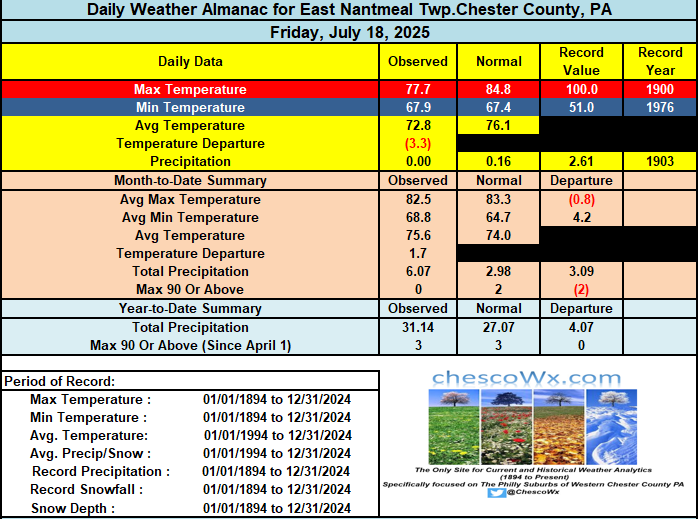
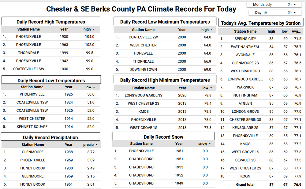
Today marks on average the warmest day of the year....we begin the slow slide toward winter tomorrow as we see our average temperatures fall before reaching their lowest on January 19th. Yesterday temperatures across much of Chester County remained in below average upper 70's to low 80's for highs. Today looks like we will see similar temperatures. There have been some light showers around the area this morning and we should see more developing later this afternoon. Tomorrow will be warmer and more humid before we turn refreshingly cooler for Monday through Wednesday with likely our best stretch of weather so far this summer. Lows by Tuesday morning should be in the 50's for most spots. We start to turn hotter again by the end of the next work week.
-
Mr J spent his HS years in SE GA. While loading up the last of stuff to move to the oldest Ms J’s apartment he replies “I thought I moved out of the armpit zone.”
-

E PA/NJ/DE Summer 2025 Obs/Discussion
ChescoWx replied to Hurricane Agnes's topic in Philadelphia Region
Today marks on average the warmest day of the year....we begin the slow slide toward winter tomorrow as we see our average temperatures fall before reaching their lowest on January 19th. Yesterday temperatures across much of Chester County remained in below average upper 70's to low 80's for highs. Today looks like we will see similar temperatures. There have been some light showers around the area this morning and we should see more developing later this afternoon. Tomorrow will be warmer and more humid before we turn refreshingly cooler for Monday through Wednesday with likely our best stretch of weather so far this summer. Lows by Tuesday morning should be in the 50's for most spots. We start to turn hotter again by the end of the next work week.
- Today
-
It’s raining again in Marysville. I thought today was supposed to be a half decent… It just seems like for the last 3 months, if there is Any chance of rain… it rains! I need this pattern in Winter…


