All Activity
- Past hour
-
There goes the warning drought. Pretty robust rotation but it’s broad.
-
This looks amazing from the Euro. Keep that moisture transport coming. Sent from my SM-G998U using Tapatalk
-

E PA/NJ/DE Spring 2026 Obs/Discussion
Albedoman replied to PhiEaglesfan712's topic in Philadelphia Region
Recent rainfall across portions of the Lehigh Valley, including approximately 1.40 inches at my location, was certainly beneficial for vegetation, lawns, crops, and surface soil moisture. However, despite this rainfall, stream base flows continue to decline rapidly, indicating that the region is still experiencing significant underlying groundwater deficits. One of the primary reasons for this is that late May and early June represent peak seasonal vegetation demand. Trees and crops are now fully leafed out and actively transpiring large amounts of water back into the atmosphere. As a result, much of the recent rainfall is being intercepted by vegetation or absorbed into extremely dry upper soil layers before it can deeply infiltrate and meaningfully recharge aquifers and groundwater systems. The geology of the Lehigh Valley further complicates drought recovery. Carbonate limestone and dolomite formations common throughout the region can rapidly absorb rainfall through fractures and karst features, while upland shale and sandstone areas often have limited groundwater storage capacity. This creates a situation where streams may temporarily rise after rainfall events but then quickly recede once runoff diminishes. Although recent precipitation has helped reduce immediate vegetation stress and temporarily improved surface conditions, true hydrologic recovery will likely require multiple widespread soaking rain events, lower evapotranspiration rates, and sustained groundwater recharge over an extended period of time before stream base flows and aquifer levels fully recover. Lehigh County also recently experienced one of its driest Aprils on record, and year-to-date precipitation deficits continue to contribute to ongoing drought-related concerns throughout the region. -
Yes sir! And a lot more to come.
-
Looks like heavy rain and storms coming in this evening.
-
Have a 8am shotgun tomorrow rain or shine…. That blows.
-
R squared FS is always way too high on qpf and bad in temps that I’ve seen so far . It’s really not usable
-
It’s still out for a couple of months. But I’ve been trying to follow rufus more since we have no choice soon.
-
1.04” . What a wet last two months . Looks like another .25-.50 for all of SNE with round two tomorrow . Looking forward to the dry Stein stretch next 10-14
-
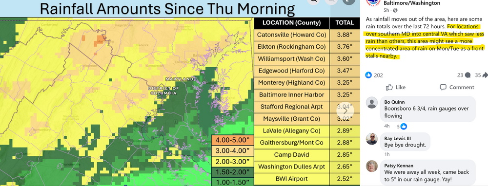
For your sake, I agree. The four inch soil moisture numbers show the winners and losers from the past several days.
-

E PA/NJ/DE Spring 2026 Obs/Discussion
Hurricane Agnes replied to PhiEaglesfan712's topic in Philadelphia Region
Have been calculating my totals from this long duration event and so far - 5/20 - 0.81" 5/21 - 0.31" 5/22 - 0.05" 5/23 - 0.74" 5/24 - 1.40" 5-day TOTAL = 3.31" (Month to date = 4.41") Today was the heaviest so far, pretty much a month's worth these last 5 days that was needed for a good soaking after that heat! Bottomed out at 50 and made it to 59 for a high. currently overcast and 58 with dp 57. -
SOI in a lengthier and stronger streak just following your daily updates reflecting the El Niño development.
-
What date was it official ? I saw the NAM today I thought
-
Spoke to soon, raining again.
-
Through 4 pm, storm total rainfall totals across the region include: Atlantic City: 0.91" Binghamton: 0.86" Bridgeport: 1.44" Islip: 1.20" New Haven: 1.38" New York City-Central Park: 1.83" New York City-JFK Airport: 1.56" New York City-LaGuardia Airport: 1.65" Newark: 1.50" Philadelphia: 1.52" White Plains: 1.38" Clouds will break tomorrow. As a result, the temperature will likely return to the lower 70s. Temperatures could then rise to above normal levels for Tuesday through Thursday. It will turn somewhat cooler to end the week. The ENSO Region 1+2 anomaly was +1.8°C and the Region 3.4 anomaly was +0.9°C for the week centered around May 13. For the past six weeks, the ENSO Region 1+2 anomaly has averaged +1.63°C and the ENSO Region 3.4 anomaly has averaged +0.70°C. El Niño conditions are now in place. The ongoing El Niño will continue to strengthen through the summer. The SOI was -31.69 today. The preliminary Arctic Oscillation (AO) was +1.772 today. Based on sensitivity analysis applied to the latest guidance, there is an implied near 75% probability that New York City will have a warmer than normal May (1991-2020 normal). May will likely finish with a mean temperature near 64.0° (0.8° above normal). Supplemental Information: The projected mean would be 1.5° above the 1981-2010 normal monthly value.
-
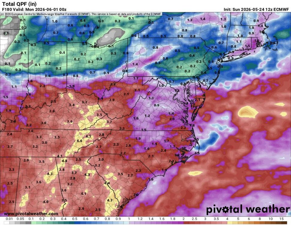
Look at that gradient right along I-95. Let's hope that highlighted part is right!
-
5.25” this week. Definitely putting a dent in the drought.
-
2.01 inches here, rain has turned to light drizzle
- Today
-
And that's how Cowser hits a bomb. Make a decent pitch and its a swing and a miss.
-
Retired. Rufus all the time now. RATT
-
Hopefully we salvage the afternoon
-
yeah, next weekend cancel
-
I’m on low side with 1.8” total
-
.45"
-
Ensembles suck next weekend too. Great.


.thumb.gif.f92b16c631a1d15d405ed77b33f0710d.gif)


