All Activity
- Past hour
-
Nov 28-30th Post Turkey Day Winter Storm
ChiTownSnow replied to Chicago Storm's topic in Lakes/Ohio Valley
Everything on track.. looks to be a little lull in the action and then cranks back up. -
Had a tease for the 6th. Does seem like that the 6th is another “real” window at least. All I can ask for at the start of the season is a few chances to keep me busy.
-
You have been wrong also. Just stop posting please. Why are people still all gloom and doom when the guidance shows a cold and active December ? I dont get this place.
-

First Winter Storm to kickoff 2025-26 Winter season
ORH_wxman replied to Baroclinic Zone's topic in New England
Yes. But prob just advisory snows. -

First Winter Storm to kickoff 2025-26 Winter season
WxWatcher007 replied to Baroclinic Zone's topic in New England
We love 'em but he's lost. John Travolta levels of confusion. This is a light to mod event in his hood. -
It did not lol
-
Nov 28-30th Post Turkey Day Winter Storm
TheNiño replied to Chicago Storm's topic in Lakes/Ohio Valley
St Louis gets no love on this board so thank you for sharing -

Nov 28-30th Post Turkey Day Winter Storm
CheeselandSkies replied to Chicago Storm's topic in Lakes/Ohio Valley
Been steadily snowing all morning in Madison but rates and flake sizes have been fairly run-of-the-mill. Hoping one of those heaver bands can make its way up here. -

Nov 28-30th Post Turkey Day Winter Storm
cyclone77 replied to Chicago Storm's topic in Lakes/Ohio Valley
Nice rippage over the past hour or so. Probably up near 6" now. Still 10+ hours to go. -
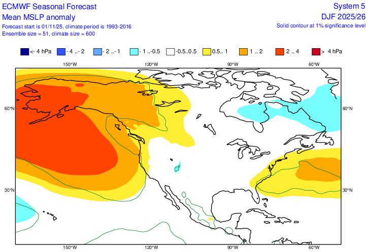
I knew I had seen the surface maps showing surface Highs moving off the coast to our east and NE. I found it. Looks like we may hve to get used to it for the winter if the Euro seasonal is correct. The link below is for the period of Dec-Feb. If you scroll forward to J-M, it's even stronger. As long as we get better cold into the area, we should still have our shots at snow. Next week's problem is only being 3-4 degrees too warm, which is more a function of the early season. https://charts.ecmwf.int/products/seasonal_system5_standard_mslp?area=NAME&base_time=202511010000&stats=ensm&valid_time=202512020000
-
First Winter Storm to kickoff 2025-26 Winter season
Snowcrazed71 replied to Baroclinic Zone's topic in New England
Come on man. Yesterday you were saying it was Rains to Maines. I still don't think it'll be that far out to see ( or that this is the final solution ). I think it'll be a light to moderate event for most of Southern New England and to Central New England. -

First Winter Storm to kickoff 2025-26 Winter season
ineedsnow replied to Baroclinic Zone's topic in New England
slightly west but still meh -

2025-2026 ENSO
40/70 Benchmark replied to 40/70 Benchmark's topic in Weather Forecasting and Discussion
Maybe I will be wrong on some aspects, which is fine...I'll learn from it....but all I ask from those who comment on my work is to accurately reference what the forecast was. -

2025-2026 ENSO
40/70 Benchmark replied to 40/70 Benchmark's topic in Weather Forecasting and Discussion
Keep thinking what? It's not subjective...I told you what my forecast was...that is objective fact. -

Nov 28-30th Post Turkey Day Winter Storm
Chicago Storm replied to Chicago Storm's topic in Lakes/Ohio Valley
3.4” storm total here at home thus far. -
I can tell you what will definitely be wrong, the absolutely asinine wishcast that there is going to be a major SSWE, total wind reversal and an SPV split by Christmas. You know, the one from the moron in PA that he follows and pirates stratospheric graphics from. That crap is going down in flames….And how he can say you were wrong with the cold for December and the trough positioning in your winter forecast for December is wrong on November 29th is simply mind-blowing. I mean unless he’s psychic and clairvoyant
-
Keep thinking that. I will bump this when I get snow next month. Carry on with snowman19.
-
Has to be great for the local economy up here to get off to such a stellar start .
-

Central PA Fall Discussions and Obs
Superstorm replied to ChescoWx's topic in Upstate New York/Pennsylvania
Looks like we all get a little from this event Tuesday. . -

First Winter Storm to kickoff 2025-26 Winter season
Damage In Tolland replied to Baroclinic Zone's topic in New England
Would the Euro or even a compromise even be snow in interior SNE? -

E PA/NJ/DE Autumn 2025 Obs/Discussion
RedSky replied to PhiEaglesfan712's topic in Philadelphia Region
Deja vu to last winter where the euro was often the snowiest -

2025-2026 ENSO
40/70 Benchmark replied to 40/70 Benchmark's topic in Weather Forecasting and Discussion
I used December 2000 as an analog for the warming in that it would narrowly miss a reversal, but also mentioned December 1981 as an example if it were to actually reverse. I said that the MJO would staddle the border of MJO phase 8 and perhaps make it into phase 8 at a reduced amplitude, which would allow other factors to potentially modulate the pattern. And I'm not sure how in the hell you are grading the nuances of the 500mb composite for a month that has yet to begin. You are absolutely desperate for snow in Central Park, I get it. -

First Winter Storm to kickoff 2025-26 Winter season
ORH_wxman replied to Baroclinic Zone's topic in New England
It’s prob gonna be a compromise lime usual. But evena compromise isn’t that great because the trend has been to keep the midlevels kind of open. So it’s gonna be weaker with dynamics and QPF. -
I'm interested is seeing whether the Euro's snowy start to the run will continue to the end as it often seems to do.
-


