All Activity
- Past hour
-
 Sounds fun !
 -
Have you tried their new taco menu? I thought they were decent.
-

Central PA Fall Discussions and Obs
mahantango#1 replied to ChescoWx's topic in Upstate New York/Pennsylvania
More wind Sunday. ABC-27 mentioned gusts of 50mph. -
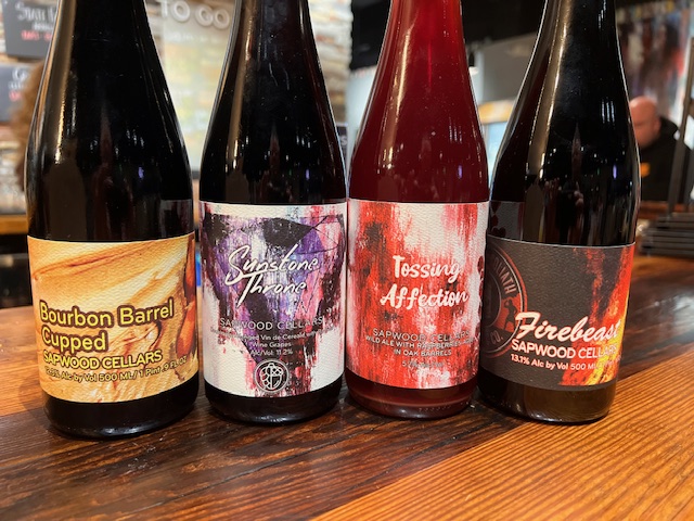
Are they selling bottles of firebeast? I thought it was just their “vintage pour” today. If you like something like a dessert stout, you will like cupped. I got 2 bottles of that the day it was released…..soooo good.
-

November 2025 general discussions and probable topic derailings ...
ineedsnow replied to Typhoon Tip's topic in New England
Just missed a good snow shower to my west and south.. few flakes here meh -
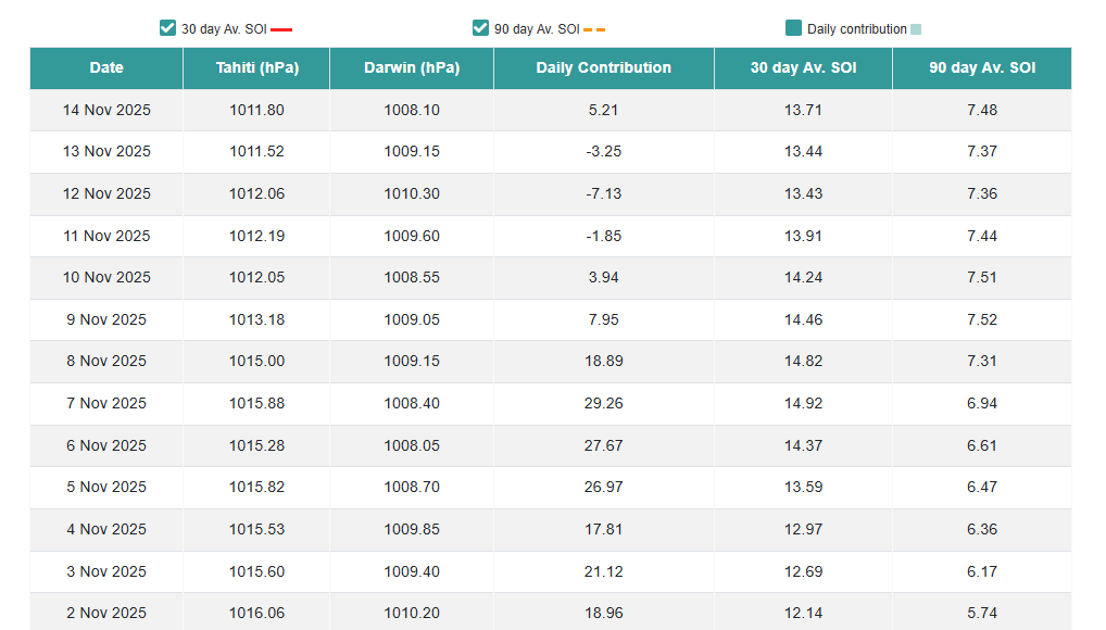
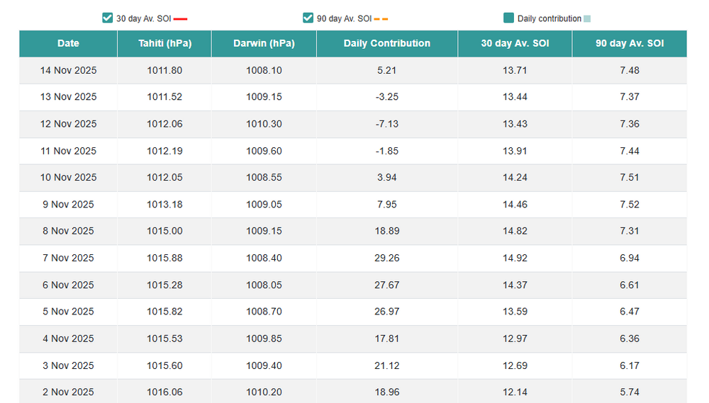
The SOI took a big rise recently.Seems like we'd be seeing some sort of strong CF, maybe the end of the month,Nov first of Dec along with the MJO possibly getting out of the unfavorable WP and possibly WH,tho the Euro Mean dont have alot of support.The SSWE today the Euro backed off of any SSWE.But the Euro does have some support it should turn colder into the first week of Dec with the ensembles.Just need the MJO to stay active,hate a warm Christmas,you always as we get into winter in out parts want to see troughs into East China into the Sea of Japan,thats a cold look as long as the NAO cooperates

-
Stopped in at Sapwood and ran into @Scraff. Impossible to leave this place without taking some home.
-

November 2025 general discussions and probable topic derailings ...
WinterWolf replied to Typhoon Tip's topic in New England
Ya, but I think it’s supposed to be you. But it’s your cyborg twin. -
Next week is setting up to be another incredible upslope week. Just really starting to enter unprecedented territory for this time of year in the northern greens. From a skier prospective, it looks like a big have vs. have nots in vt. The difference in the totals for the jay/stowe/smuggs/bolton corridor vs. killington south looks dramatic. .
-
Yeah looks like a solid gradient pattern is coming
-
Mostly cloudy and 51. HH on the deck.
-
signals an active storm track. pretty good look for NE, and maybe even the MA
-
-
It’s not though .Most of it is someone else he AI in
-
-
Love it
-
Today was not supposed to be this snowy. Just a glorious afternoon.
-

November 2025 general discussions and probable topic derailings ...
CoastalWx replied to Typhoon Tip's topic in New England
You as a priest and creepy voice and smile. -
I don’t hate this. Not as cold as some are advertising out there, but seems to like an active storm track


-
Who is it ?
- Today
-
Yes, it's warmer today. But the 1930s were quite warm too, especially in North America. So warm, in fact, that certain people like to constantly bring them up to "rebut" climate change. A few notable cold snaps don't change that fact. New York City's moving 30-year mean annual snowfall was pretty steady between 32 and 34 inches until the mid 1920s - and that's generally with measuring the new fallen depth, not snowboards and 6 hourly or more frequent measurements. So, the "snow drought" from the late 1920s and early/mid 1930s was certainly a big departure from the long-term climatology.
-
November 2025 general discussions and probable topic derailings ...
CoastalWx replied to Typhoon Tip's topic in New England
That’s disturbing. -
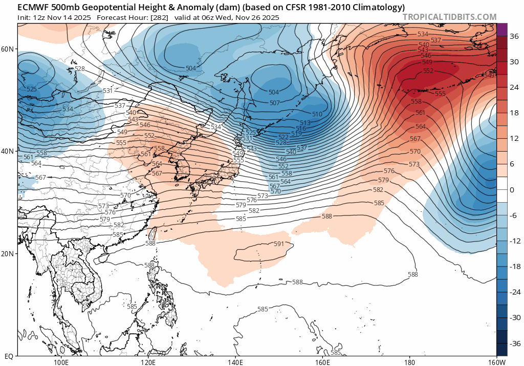
The EPS is on an island right now. The Euro Weeklies, after being locked-in for weeks, have flipped to AN temps for week one of December and normal for week 2. It is definitely "can kicking." On the other hand, the GFS and Canadian ensembles and LR ext models have assumed the Euro Weeklies former "cold is king" spot. Welcome to shoulder season modeling. The CFSv2 at lunch was just ridiculously cold w/ the ridge heights and trough lows. We are talking subtropics to the NP. That is not a stable pattern, and probably why we see differences. But....that is a pattern which could deliver insanely cold air into the Lower 48. The December which Boone referenced and 89 would be on the table as ensembles. I "think" cold is coming, but going into battle with the Weeklies flipping doesn't give me great confidence. I often wonder if the Euro Weeklies are about 1-2 days ahead of other LR ext models w/ better data. With the Weeklies trending away from a cold start to December, I would think other LR ext models will do the same during the next couple of days - if they are actually going to flip. BTW, the 500 pattern isn't terrible on the Euro Weeklies, but it isn't cold either. The SSW....has screwed up more than one great cold snap during the past decade. That event often wrecks havoc on modeling and can inflict damage on what looked like a promising even. The SSW....most likely we are looking at modeling bouncing around due to low level cold air being underneath those 500 patterns. Might as well drop a cat in a bathtub - cause all you know what is gonna break loose. Overall, I think cold is coming just after thanksgiving, but with a strong word of caution. FWIW, I generally like the CMC when cold is in the forecast at medium and long range. It often over-does the cold, but it actually "sees" it. I would feel a bit better if the Euro and EPS hadn't been right about this last system, and "at range" to boot. But the GEFS was sneaky good as well - just not the GFS. The GEFS looks like a good compromise for the two weeks after Thanksgiving.
-
75 in Champaign
-
Temperatures have overachieved today and we’ve set a new record high in Minneapolis. 72 breaking the old record of 71