All Activity
- Past hour
-
Still all snow here, 28 degrees
-
ORD received 8.4" of snow on November 29th, which broke the record snowfall total for the date of 2.4" (1953). ORD received 8.4" of snow on November 29th, which broke the November all-time calendar day record snowfall total of 8.0" (November 6th, 1951).
-
Been holding a steady 28 here toward the coast all day long. Bounced from 28.2 - 28.9 at the peak but sitting solid at 28.0 even again now. Hoping it stays that way!
-

Chicago Weather Records Tracking
Chicago Storm replied to Chicago Storm's topic in Lakes/Ohio Valley
Chicago/O'Hare received 8.4" of snow on November 29th, which broke the record snowfall total for the date of 2.4" (1953). Chicago/O'Hare received 8.4" of snow on November 29th, which broke the November all-time calendar day record snowfall total of 8.0" (November 6th, 1951). -
Spent most of the day in S RI and rain and temps around 45F, now home in E CT and temp 34F and .40” of rain so far
-
Bro you must make some big cash…got so many Pits I can’t keep up. Holy smokes.
-
LWX mentions the next 2 chances... Model guidance is in relatively good agreement that a low amplitude shortwave embedded in west-southwesterly flow aloft will track across the Tennessee Valley toward the southern Mid-Atlantic during the day on Friday. Meanwhile, high pressure will be in the process of retreating offshore. While models are in agreement that this general pattern will unfold, there are still some discrepancies with respect to how far north precipitation will make it, and also what the precipitation type will be. The majority of solutions have cold air in place at the surface, which would favor wintry precipitation (either a wintry mix or snow). However, there are some solutions that show rain across southeastern portions of the forecast area. Overall, precipitation totals should be on the lighter side. Depending on the track of the system, a couple inches of snow or a light wintry mix may be possible across portions of the forecast area Friday afternoon into Friday night. We`ll continue to monitor this system over the coming days. Dry, but chilly conditions are expected across the area this weekend. High temperatures are forecast to be in the upper 30s and lower 40s, with low temperatures in the 20s. Forecast confidence decreases significantly by Monday, with some solutions developing an area of low pressure nearby as a shortwave trough moves through aloft. Other solutions maintain dry conditions.
-
Completely agree. The pattern looks extremely hostile to KU’s up the coast through at least mid-December and very likely beyond that time frame
-
Sleet might be starting to mix in here in ASH. NAM may have nailed the 900-950 warm layer it is pushing up toward MHT that the other short-range mesos aren't seeing.
-
Almost seem like Nam 84 would look better for the weekend storm. Seems like we need to lose the Dec 5th storm to gain the weekend storm. On that note 18Z icon shows hope for the 5th
-
It's 46* right now at the new Pit. Such an easy forecast for down there.
-

First Winter Storm to kickoff 2025-26 Winter season
WinterWolf replied to Baroclinic Zone's topic in New England
What piece of crap. Modeling in general absolutely sucked for this…abysmal. -
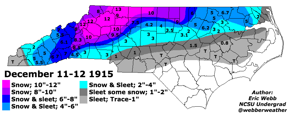
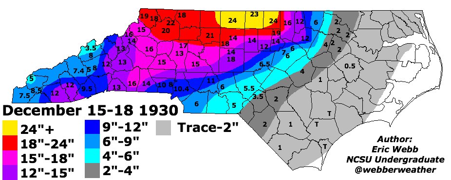
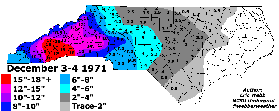
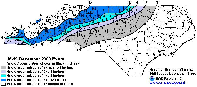
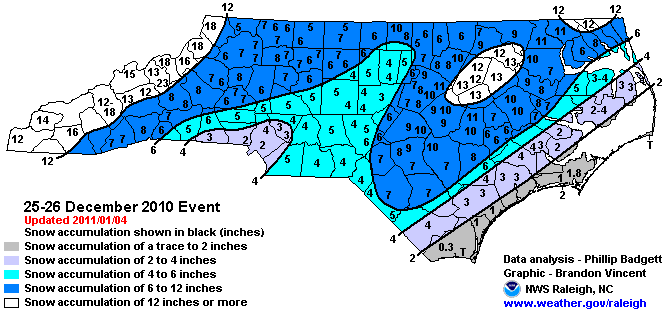
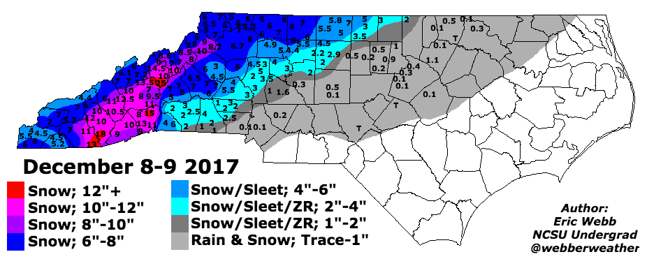
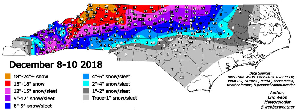
Best WNC December snow storms of all time. Courtesy of webber weather
-
This is downright ugly for the SE 12/15-1/12 (ECMWF site, itself, is warmer than WxBell’s interpretation), but I’m hopeful it’s overdoing the SER.
-
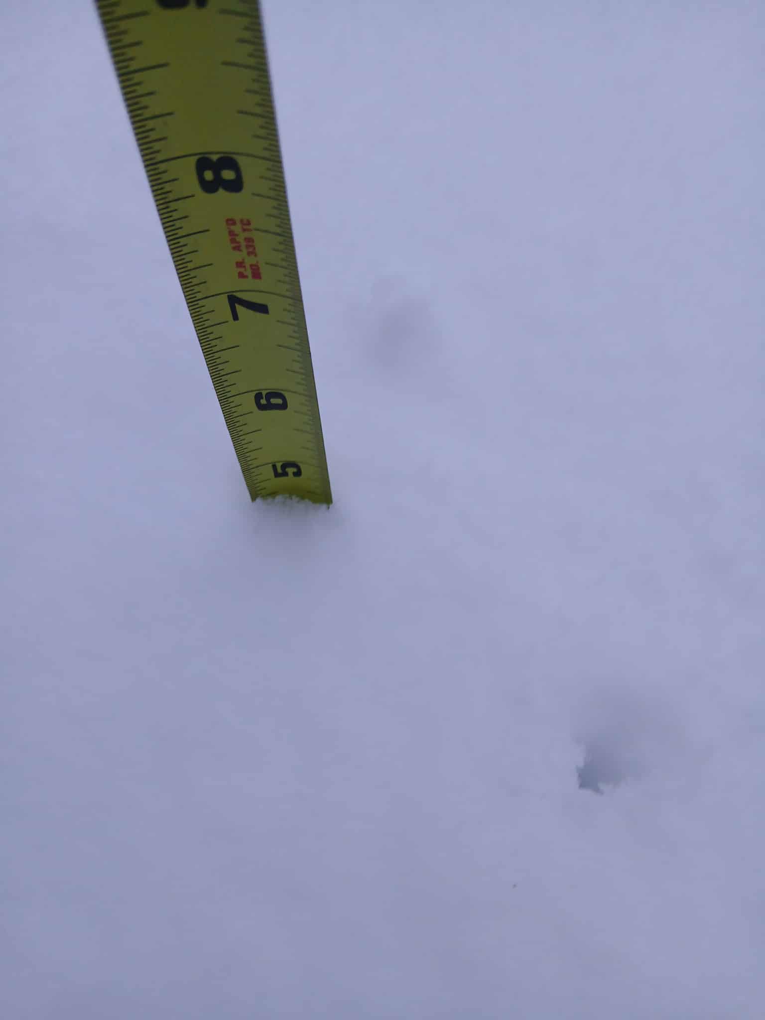
Just over 4.5

-
25.7° SN 5.9”
-
Man the snowgrowth is just putrid. You could see it coming but it still hurts to watch.
-
 This cyclone, aka Senyar, ended up causing terrible flooding in Thailand, Malaysia and Indonesia (mainly Sumatra). According to Wikipedia more than 1,000 people were killed, and the storm caused nearly 20 billion dollars in damages - apparently the costliest Indian Ocean cyclone ever. All as just a moderate tropical storm and tropical depression.
 -
December 2025 regional war/obs/disco thread
WinterWolf replied to Torch Tiger's topic in New England
A cutter and a reload is fine with me. -
30/28 -SN 2.8" total so far in Salem NH. Watching that mix line creeping toward us.
-

December 2025 Short/Medium Range Forecast Thread
Carvers Gap replied to John1122's topic in Tennessee Valley
And there is more. This is where the 12z GEFS left things at the end of its run. That is a cold look with two mechanisms with which to send cold southward out of Canada - EPO ridge and blocking over Greenland. And to get great winters, we need some SER. -
Can we reserve a couple big tables/Booths? Or do they not allow that?
-
31F with freezing rain.
-
Another truly awful performance by some models at short range, but the writing was on the wall with the extent of cold and low dews. Tip of the cap to…Tip, who saw the ZR potential. That’ll cost me some points in my forecast final grade.
-
 Down to 37 on the N wind. About as nasty as it gets. Get it the F out ASAP.