All Activity
- Past hour
-
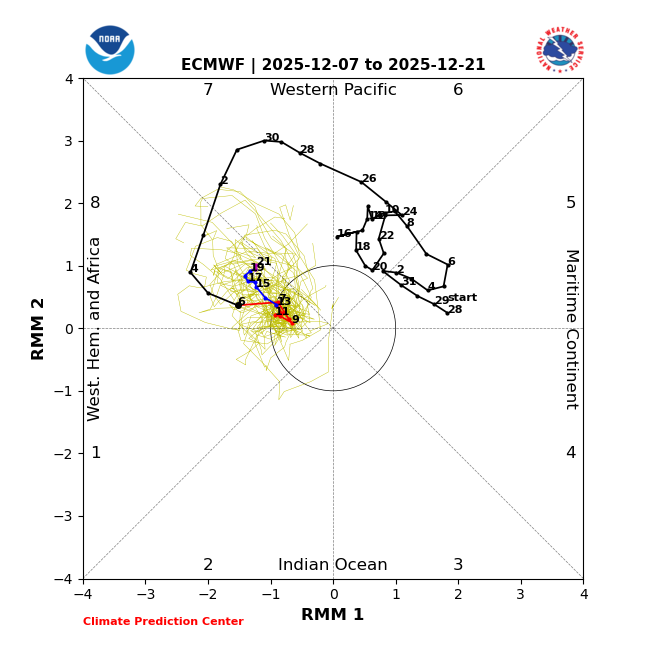
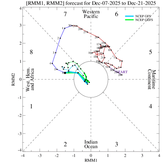
The pattern goes zonal at the end of the latest EPS and GEFS runs leading up to Christmas, but verbatim temps would be average to slightly below. 15 days out so fwiw as always.
-

E PA/NJ/DE Winter 2025-26 Obs/Discussion
PhiEaglesfan712 replied to LVblizzard's topic in Philadelphia Region
If we don't get any snow by the end of December, then I think it maybe time to give up hope. I can't remember a time when we had a good snowy rest of the winter after a cold and low snow December. Almost always, January and February torched in years like that. -
A very frosty 25
-
-
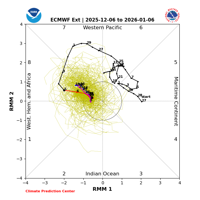
Expect cold most likely for the rest of the month with a negative WPO and MJO in phase 8.
-

December 2025 regional war/obs/disco thread
WinterWolf replied to Torch Tiger's topic in New England
Yes sir. -

Dec 6-7th (It's not a clipper) Clipper
kevlon62 replied to Chicago Storm's topic in Lakes/Ohio Valley
5 miles south and just under 5". Slightly denser. Ratios did their work.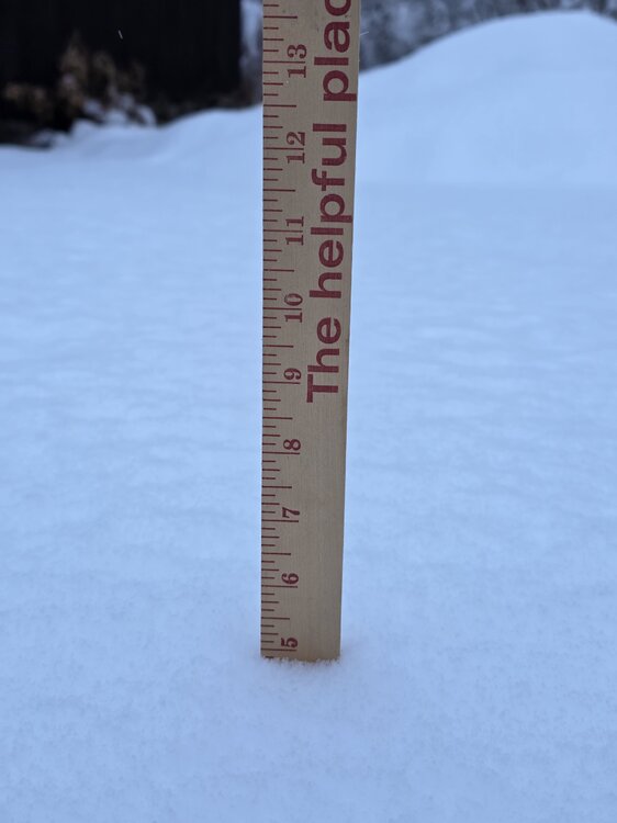
-

December 2025 regional war/obs/disco thread
Baroclinic Zone replied to Torch Tiger's topic in New England

-
 Most of them verified but there has been only a handful
 -
Winter 2025-2026 Offers Return to Normalcy
Baroclinic Zone replied to 40/70 Benchmark's topic in New England
Nice write ray. -
Models more or less hold steady overnight. Temps going to be an issue even as the heavier snow moves through, holding in the mid 30s in the Triad per model consensus. Probably would be a bit colder in the heaviest bands, but if the better dynamics are north of the VA border as the Euro and RGEM show, we could get blanked again
-
December 2025 regional war/obs/disco thread
WinterWolf replied to Torch Tiger's topic in New England
What are you confused about Kev? -
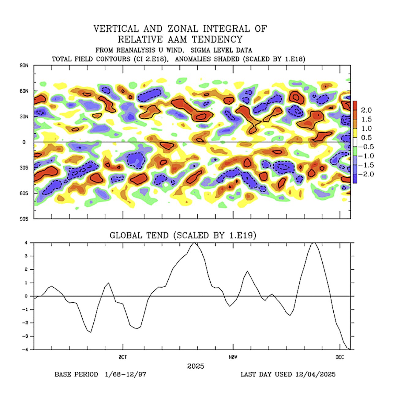
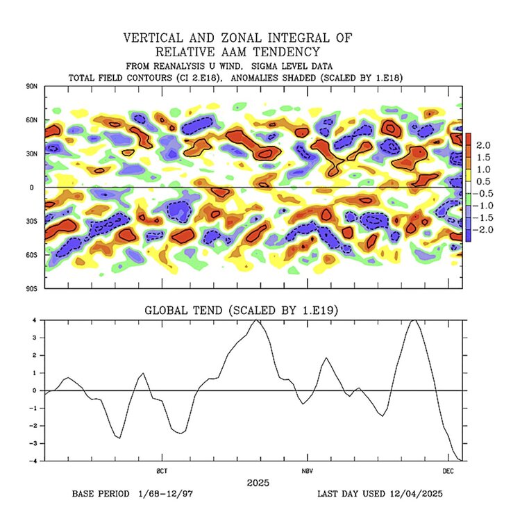
The current standing wave in MJO 4-6 will consolidate the forcing there leading to a jet extension in around 10 days and the ridge getting pushed east with the falling AAM.


-

Dec 6-7th (It's not a clipper) Clipper
A-L-E-K replied to Chicago Storm's topic in Lakes/Ohio Valley
Overperforming nicely -
Dec 6-7th (It's not a clipper) Clipper
A-L-E-K replied to Chicago Storm's topic in Lakes/Ohio Valley
Overperforming nicely -

December 2025 regional war/obs/disco thread
Chrisrotary12 replied to Torch Tiger's topic in New England
So much for today’s wintry appeal. -
December 2025 regional war/obs/disco thread
WinterWolf replied to Torch Tiger's topic in New England
Yup…I feel it’s better to see this than some bomb at 6-7 Days that we know will be all over the map, driving folks nuts. A good signal is what we want at this lead….the eventual system will emerge as we close in. -
The 13-15 has my interest. Obviously could go to shit, but it has a look that I haven’t seen in awhile. I think I would lean off the explosive look (not impossible) and hope for a 3-6 4-8 deal. there’s probably another opportunity or so within a few days after that, and then we’ll probably warm up towards the 18th to the 20th. But after that, it looks like there’s gonna be quite the gradient setting up somewhere in the other 40th parallel so. Just hope to be on the good side of that.
-

Dec 6-7th (It's not a clipper) Clipper
sbnwx85 replied to Chicago Storm's topic in Lakes/Ohio Valley
2.2” so far. -
December 2025 regional war/obs/disco thread
Baroclinic Zone replied to Torch Tiger's topic in New England
I’m seeing that as well. We take. -
There is still a shot at some snow late week, probably Friday. Multiple cold fronts coming through mid week into the weekend with all sorts of vorticity in the flow. Hard for models to pin down. Probably something on the lighter side if it does happen.
-
Ground zero
-

2025-2026 Fall/Winter Mountain Thread
Maggie Valley Steve replied to Buckethead's topic in Southeastern States
No freezing fog at the house this morning. It's currently 25 which is my low. Snow makers are busy up at Cataloochee and Tube World here in town. I'm not expecting much from the system coming in overnight into tomorrow. Late this week we are likely to get the coldest air of the season as lobes of Arctic air heads our way. It's too soon to know if we will have precipitation arriving with the Arctic front. -
Dec 6-7th (It's not a clipper) Clipper
kevlon62 replied to Chicago Storm's topic in Lakes/Ohio Valley
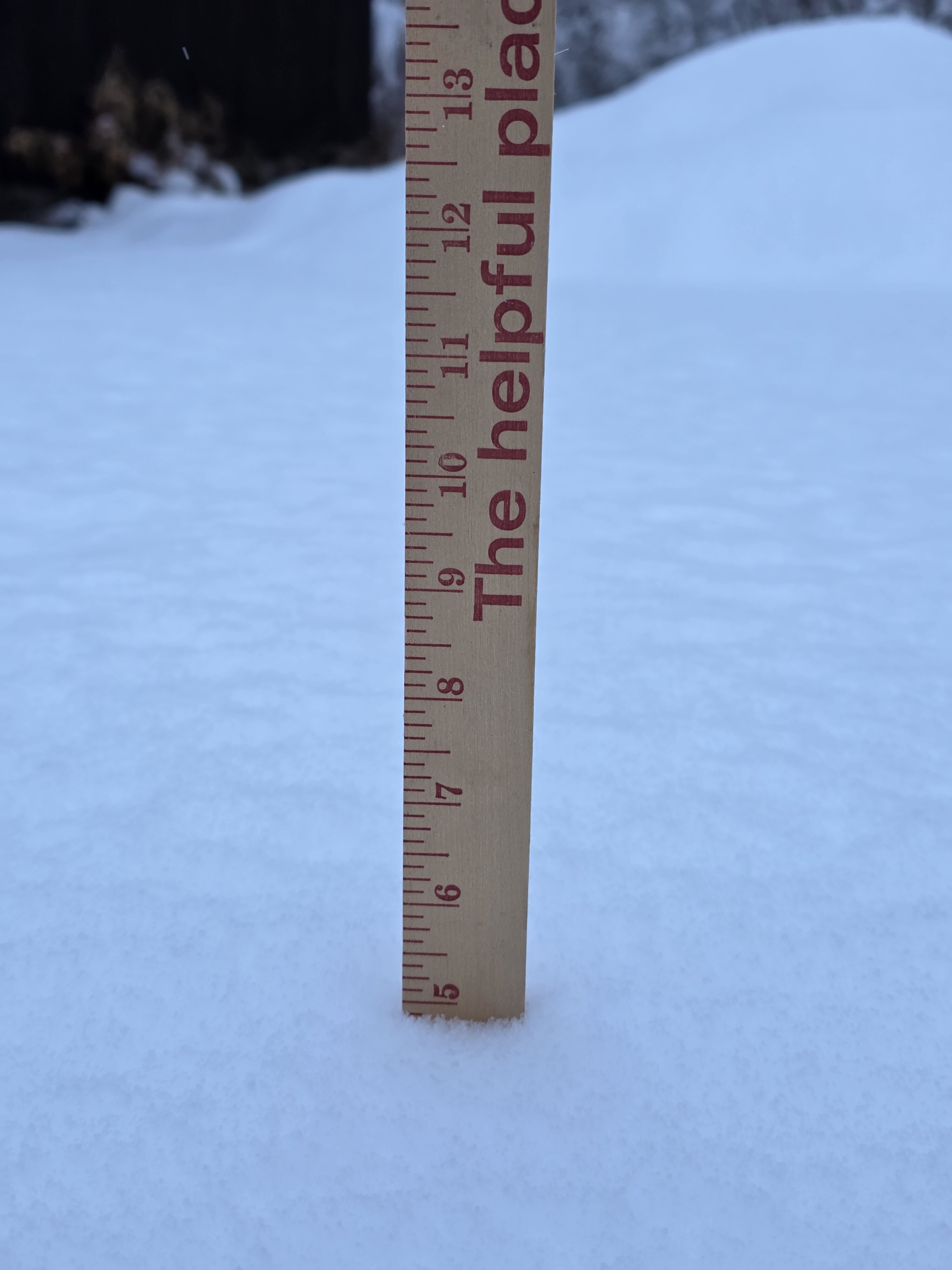
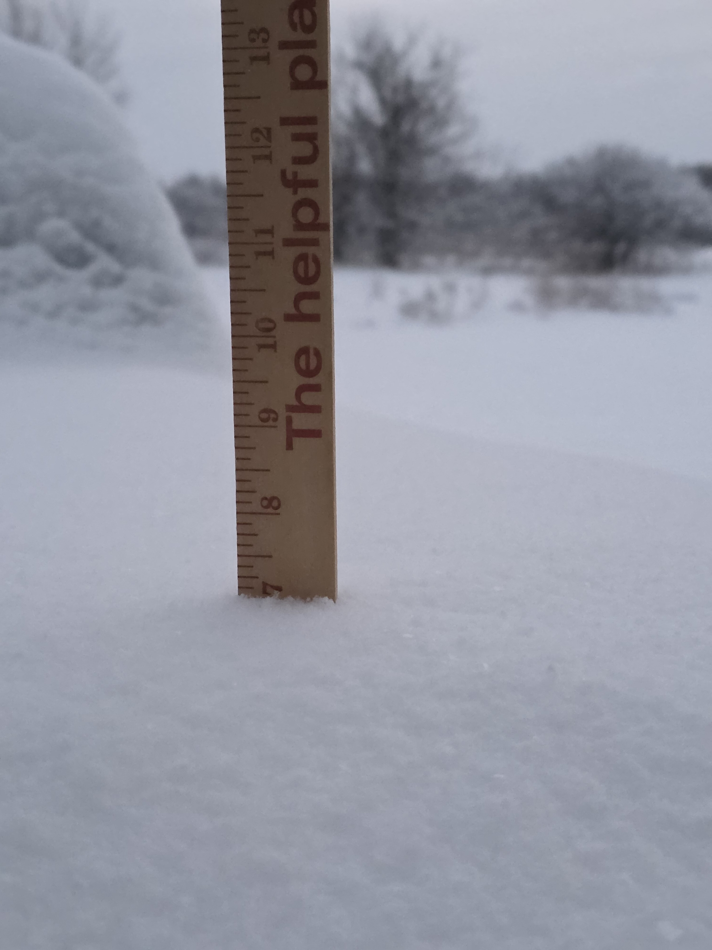
Another Sunday morning waking up to the goods. 7" on the mark.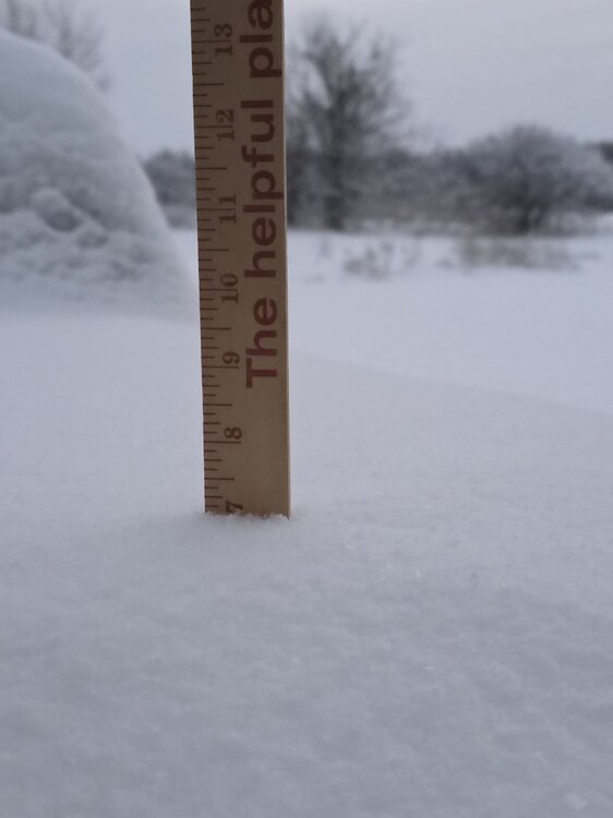
-