All Activity
- Past hour
-
 Down to 37 on the N wind. About as nasty as it gets. Get it the F out ASAP.
 -
Ended with 1.98" for the day. Temp sitting at 58. Waiting on the front to come through.
-
Very weird. Been 'snowing' since 7am, looking at 2-2.5" so far. 24° very light snow continues
-
Just starting to taper off now at 6.5", maybe that last band swings through and freshens it up a bit. I'm liking the new latitude so far
-

December 2025 Short/Medium Range Forecast Thread
Carvers Gap replied to John1122's topic in Tennessee Valley
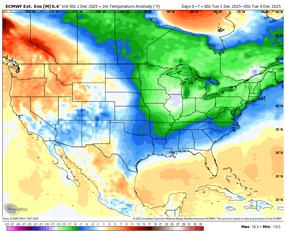
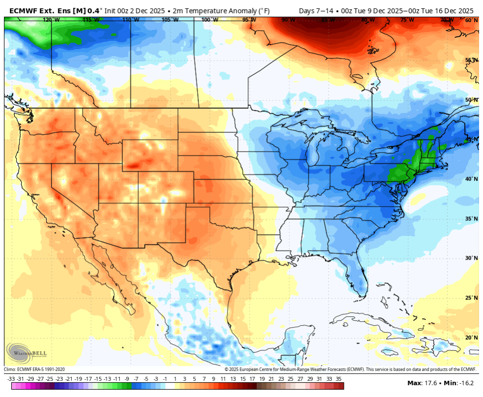
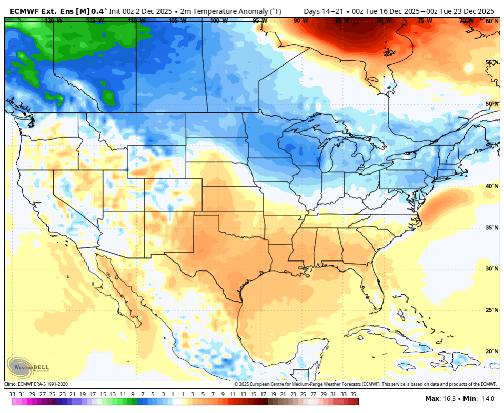
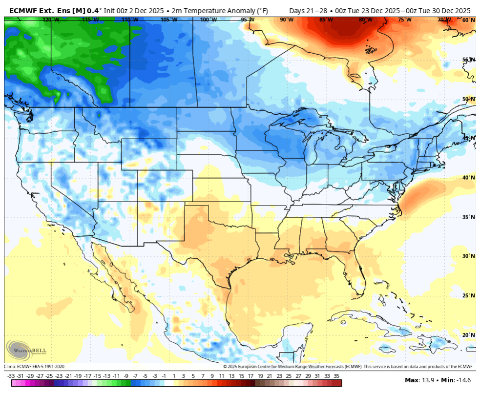
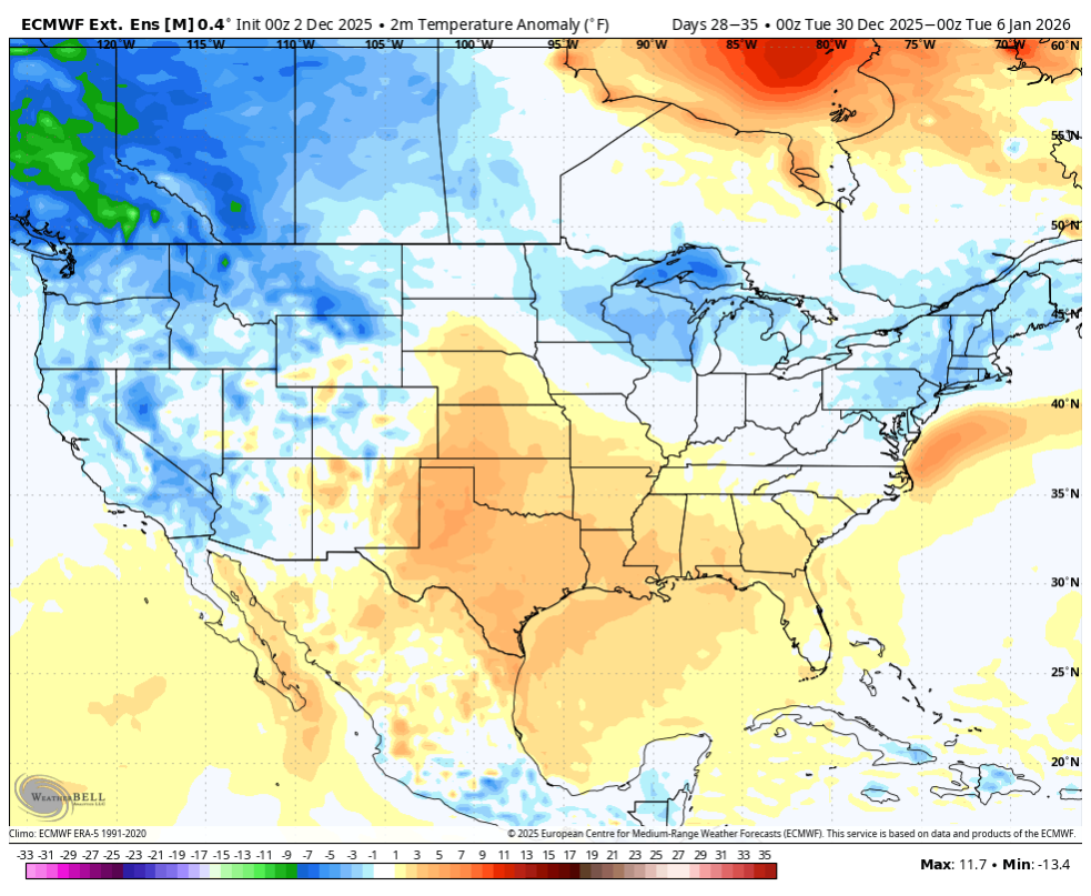
Then compare those to the very end of the 12z Euro. See that big ridge in Alaska? We know the Euro has a tendency to feedback in the West. If that trough corrects eastward(which it should) and it is actually real, that sets the stage for very cold air to rapidly flood into the NA mid-section. As Boone noted above, it is very common for extreme warmth to get pulled ahead of strong cold shots. You can see the warmth surging into New England. During old school winters, many great cold shots were preceded by storms and rain. There is also a path to very warm temps. But beware. We have noted that modeling feeds back in the Southwest. But...it also feeds back in the lee of the Rockies in Canada when extremely cold air enters into NA. IF the MJO rolls into 8 and doesn't do the GMON stall in phase 7, that cold will likely get kicked southeastward. That is why I am very interested in the next few days of MJO plots. If they get to 8, even in the COD, that likely means the trough is in the East. -
Snow growth really improving in these bands. 3.25”
-
ORD received 1.2" of snow on November 10th, which broke the record snowfall total for the date of 0.4" (1991).
-
Mixing into SnH now.
-
We had an hour of light rn or zr and back to moderate snow for the last 20 mins
-

Chicago Weather Records Tracking
Chicago Storm replied to Chicago Storm's topic in Lakes/Ohio Valley
Chicago/O'Hare received 1.2" of snow on November 10th, which broke the record snowfall total for the date of 0.4" (1991). -
A bit over 3" here in Monson, MA before we lost Cottontail in favor of Flopsy and Mopsy.
-

12/3 Snow/Sleet/Mix Bag of Everything Discussion/OBS
BBasile replied to Mikeymac5306's topic in Philadelphia Region
Ended up with 0.92" of rain. Good stuff. -
snow is getting wetter now.. hopefully we can knock some stuff down later
-

Kick-Off '25-'26 Winter Storm Obs
Damage In Tolland replied to 40/70 Benchmark's topic in New England
Yeah that’s not happening here . Bare ground as far as eye can see . Should be great and enjoyable to look out and enjoy Friday morning when it’s 4 degrees and winds gusting to 40 -
We need the energy to drop in and lead and not trail the NS, maybe it work for once
-
 Lmao…ya A’s for Frieken Awful .
 -
Weeklies


-

December 2025 regional war/obs/disco thread
Kitz Craver replied to Torch Tiger's topic in New England
The one thing I don’t like seeing is all models honing in on a warm up/cutter mid month. I guess that’s better than Christmas Eve/Day… -
Nice. Ice and sleet here today. At least the cold over performed for a lot of us.
-
Been 98% rain here for hours, but at least it started as snow lol
-
You're right. Rule of thumb should always be disregard anything past it's 78 hour wheelhouse.
-
Raw and cold and damp with freezing rain…about as uncomfortable as it gets out there right now. Yup same temp here Don…cold hung real tough all day.
-
It's just mixed back to mostly moderate snow in Westfield.
-
CAB in effect as now 2.5 days out. i no longer rely on models for anything nearly specific and just the very general low to our south which may be string or weak and may curl up the coast or go out to sea. All possibilities will be shown so models score well come verification of outcome This last event was a departing high off Maine and that showed early and that’s what happened . Never good for us.
-
12/2 - 0.7” climo = 26.5” 2024-25: 17.2” 2023-24: 15.7” 2022-23: 5.3” 2021-22: 15.2”


.thumb.png.4150b06c63a21f61052e47a612bf1818.png)