All Activity
- Past hour
-

Nov 28-30th Post Turkey Day Winter Storm
Chicago Storm replied to Chicago Storm's topic in Lakes/Ohio Valley
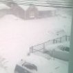
METAR KORD 291951Z 13011KT 1/4SM R10L/2600V3000FT +SN FZFG VV007 M02/M03 A3011 RMK AO2 SLP205 SNINCR 1/5 P0005 T10221033 $ -
This is the way
-

First Winter Storm to kickoff 2025-26 Winter season
Ginx snewx replied to Baroclinic Zone's topic in New England
-

First Winter Storm to kickoff 2025-26 Winter season
Sey-Mour Snow replied to Baroclinic Zone's topic in New England
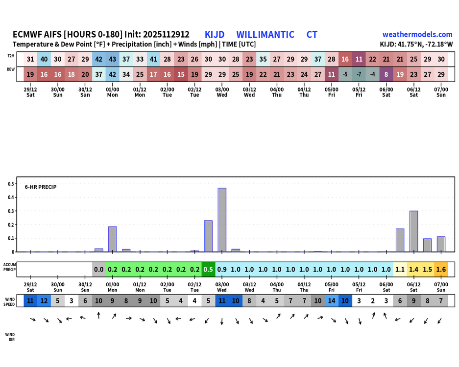
No doubt about last year underperforming we ended up getting like 5-10” in 2 week from the 18-24” mean that we had. But this does mean that the threats are there. Im leaning white rain to rain up to I-84 / coating to 2” 84 corridor / 2-5” highest hills NW for now. -
Nov 28-30th Post Turkey Day Winter Storm
Chicago916 replied to Chicago Storm's topic in Lakes/Ohio Valley
In Mequon and it's mod-heavy snow with decent sized dendrites. -
90-100%. EPS smoking that good stuff today
-

Nov 28-30th Post Turkey Day Winter Storm
Chicago Storm replied to Chicago Storm's topic in Lakes/Ohio Valley
Lake enhancement showing up all along the WI shoreline. It might work in a negative way though, with surface temps running a bit higher and snowfall ratios likely a bit lower as well. -
u know it's getting serious when bluewave lets out a hint of optimism.
-
First Winter Storm to kickoff 2025-26 Winter season
eduggs replied to Baroclinic Zone's topic in New England
5 days ago there was barely the hint of a ripple of a shortwave across the central US... And a big trof along the west coast. -

First Winter Storm to kickoff 2025-26 Winter season
Damage In Tolland replied to Baroclinic Zone's topic in New England
He definitely copied yours -

December 2025 Short/Medium Range Forecast Thread
jaxjagman replied to John1122's topic in Tennessee Valley
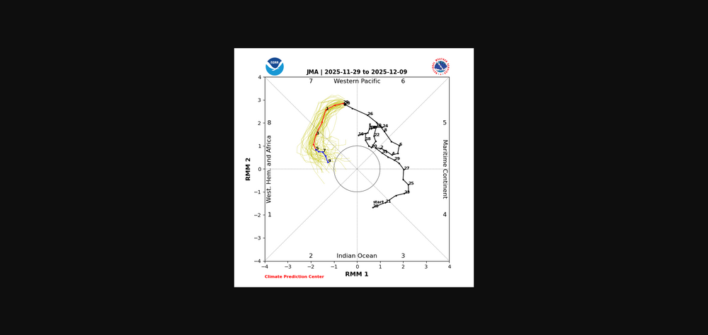
IMHO out in the Pac there is alot of stuff going on with Rossby and Kelvin waves,this is why all the models seem to be struggling with the RMM,even the JMA which has been more tightly bunched is now showing more spread today.You'll more than likely in the next few days see some swings in modeling -
Nov 28-30th Post Turkey Day Winter Storm
Radtechwxman replied to Chicago Storm's topic in Lakes/Ohio Valley
Snow looks like it's going to end early here at least. This definitely was an underperformer for me. Was supposed to get 8-12in. Idk if I will even hit that range. Snow quality was a killer early on then all this good banding really hammered I72 south of me. Looking at radar the system seems to be moving very fast. -

Nov 28-30th Post Turkey Day Winter Storm
Harry Perry replied to Chicago Storm's topic in Lakes/Ohio Valley
Very fine pixie dust coming down, just enough for black ice on many rural roads. Started around 11:30, have a compacted half inch or so. Should be picking up here soon. -

First Winter Storm to kickoff 2025-26 Winter season
WxWatcher007 replied to Baroclinic Zone's topic in New England
For early December this is great, but I recall some epic means last season that produced nothing. Not sure if I’ll do a map today but I’m currently thinking C-2 coast including most of New London County and 2-5 elsewhere. -
Say what? .
-
Winter 2025-26 Medium/Long Range Discussion
HillsdaleMIWeather replied to michsnowfreak's topic in Lakes/Ohio Valley
Gfs has ANOTHER storm next weekend lol -

Nov 28-30th Post Turkey Day Winter Storm
Chicago Storm replied to Chicago Storm's topic in Lakes/Ohio Valley
If things continue to pan out as they have thus far, ORD is on track to have a top 5 November snowstorm on record. -

First Winter Storm to kickoff 2025-26 Winter season
Sey-Mour Snow replied to Baroclinic Zone's topic in New England
Ya don’t recall seeing the ensemble means this snowy on all ensembles in early to mid December. Multiple threats to track, Howell we can cash in on 1 or 2. -
Nov 28-30th Post Turkey Day Winter Storm
CoachLB replied to Chicago Storm's topic in Lakes/Ohio Valley
stacking endless Virga -
Let’s talk winter!! Ohio and surrounding states!! 24'-25'
CoachLB replied to buckeye's topic in Lakes/Ohio Valley
endless virga? -
It looks like you are going to have to be 40+ miles N and NW of NYC (Orange, Sussex, Putnam) to get into accumulating snow from this one
-
If surprize snow does fall,this is the week historically for it. It might even snow a little tomm am. Who really knows anymore?
-

First Winter Storm to kickoff 2025-26 Winter season
Ginx snewx replied to Baroclinic Zone's topic in New England
Only thing that has varied, and it huge, is the intensity and mid levels.At any rate even a 2 inch cover here would be a great start. Tomorrow's system was at day 5 was a possible snowstorm but alas its dumping at Ohio State Michigan game. We cut we bleed -
.4" here!


