All Activity
- Past hour
-
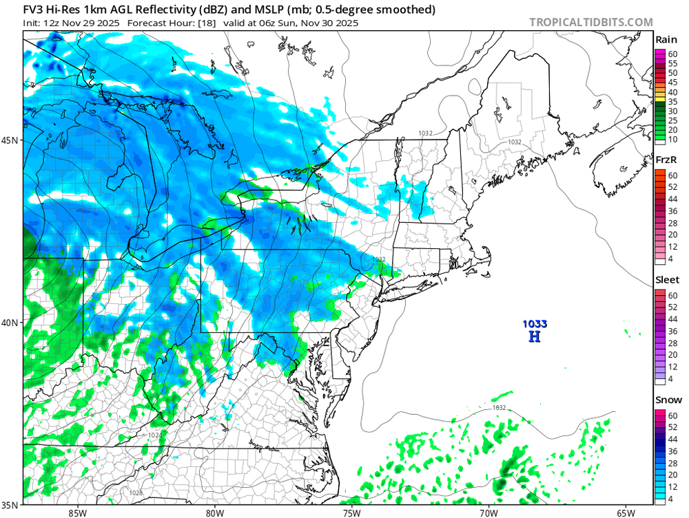
Just going to include tonights little thump in this thread. FV3 and 3k both have it. RGEM not so much.
-
My first indicators of how future modeling will go, the NAM and RGEM. RGEM tends to be a warmer model. NAM tends to be quite amped at times. Still, I need to know whether NYC is still in the game for first measurable of the season. If the NAM 60-84 have NYC in some sort of snow, especially early Tues...thats good news, not necessarily correct. If the RGEM is likewise earlier and colder ptypes=qood news. You'll be more to date than I but that's how I read Global tendencies (OFF the mesoscale models - NAM supposed to go away in 2026). I do think the GFS is and has been too amped but this will be a significant short wave cutting east across NJ 00z/Wed so I foresee intensification as it rips negatively out into the north Atlantic. Tremendous RRQ lift from the St Law Valley 250MB 180 speed max.
-

November 2025 general discussions and probable topic derailings ...
dendrite replied to Typhoon Tip's topic in New England
-
Temp dropped to 29 early yesterday evening, then rose to 37 by midnight before dropping to our low of 28. Nice hard freeze as temp stayed below freezing for a good solid 6 hours. I really hate living so close to the water this time of the year.
-
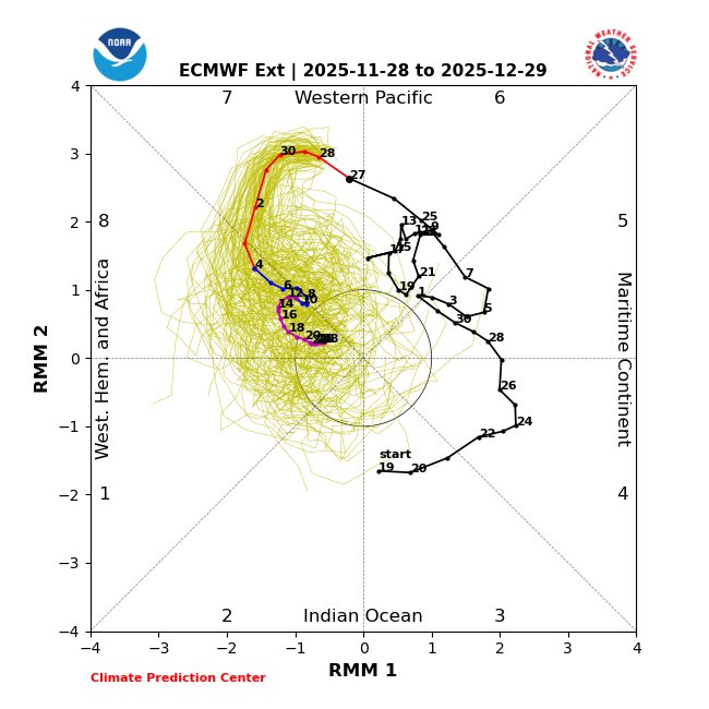
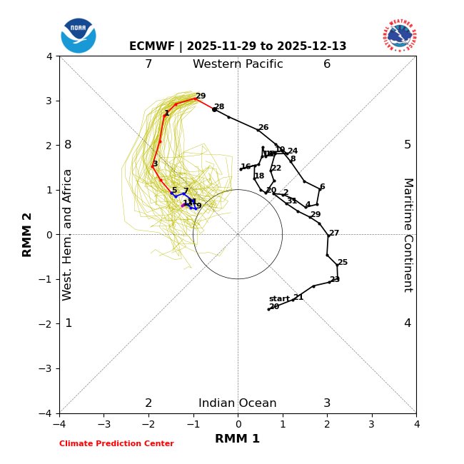
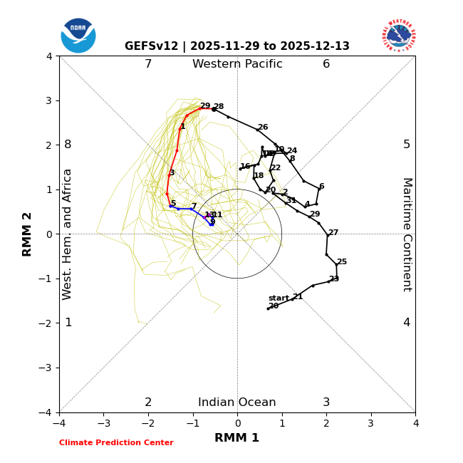
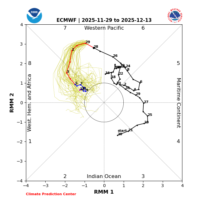
MJO from today’s 2 week runs: both now have 11+ day long phase 8s, longest since Feb 2010 and longest Dec since 1975. GEFS is all in 8 12/3-13 vs yesterday’s 7 for same period: EPS is same as yesterday:
-
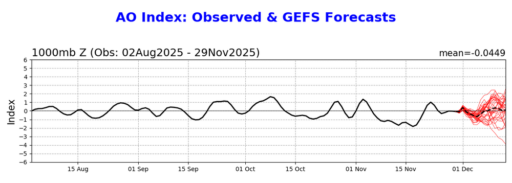
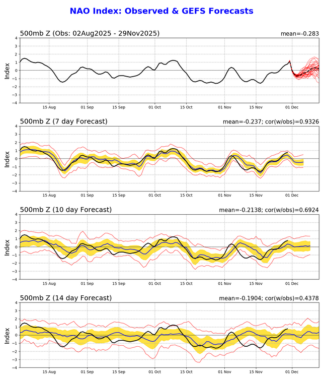
@donsutherland1 Out of curiosity, do you have any temp/precip composites for +EPO, +PNA, -AO, -NAO Decembers?
-
Paul Roundy @PaulRoundy1 The west Pacific warm pool is changing shape. Eventually it will allow for more convection near the Dateline, which can favor western N. America ridges. Paul Roundy @PaulRoundy1 38m If the western ridge is far enough west, it can favor a central N. American trough and eastern ridge. 1997 Feb-Mar had eastern US ridging in spite of central Pacific convection.
-
A mid winter look in late November. Rare.
-
Lets hope that is a harbinger of the winter that is coming...
-
thread the needle as always. just very hard for the city to good snows now in general, regardless of if its dec, jan or feb.
-
-
Nov 28-30th Post Turkey Day Winter Storm
King James replied to Chicago Storm's topic in Lakes/Ohio Valley
Nice little storm. Good flakes on a Saturday morning after a holiday. Can’t ask for more -
-

Central PA Fall Discussions and Obs
mahantango#1 replied to ChescoWx's topic in Upstate New York/Pennsylvania
-
Yeah that's not happening, esp from the Fall line east. If I am up early enough maybe I will see a few mangled flakes before it turns to rain.
-
-
First Winter Storm to kickoff 2025-26 Winter season
dryslot replied to Baroclinic Zone's topic in New England
In the past, Euro would bury that vort and lag it coming out of the SW, Not saying that's the case on this one, If i had to make an preliminary early forecast based on what modeling has right now, I would favor something a bit Weaker, Flatter, A bit SE and progressive for the track. -

Central PA Fall Discussions and Obs
Jns2183 replied to ChescoWx's topic in Upstate New York/Pennsylvania
This is just going to lead to playoff expansion. That is for sure. Probably like top 5 teams in Big Ten and SEC standings and some combination of the rest Sent from my SM-S731U using Tapatalk -
the euro has kinda trended like 10 miles south each run since yesterday. maybe i'm hallucinating but we maybe have a shot?
-

Central PA Fall Discussions and Obs
Jns2183 replied to ChescoWx's topic in Upstate New York/Pennsylvania
Where is your backyard again? Sent from my SM-S731U using Tapatalk -

Nov 28-30th Post Turkey Day Winter Storm
Michigander replied to Chicago Storm's topic in Lakes/Ohio Valley
I see mention of a lake effect event taking shape Sunday afternoon in the NW Indiana AFD. Trying to decide whether to drop off my daughter in Chicago on Sunday afternoon (returning to GR in the evening), or have her take an early train Sunday morning from Grand Rapids instead. Temps look to be in the low 30s on Sunday which usually means the roads are OK. That said, I-94 during a winter storm warning is rarely a good idea. A mid level dry slot still looks to overspread the area overnight into early Sunday morning, with a quick tapering of snow across most of the area and a likely transition to light snow/areas of drizzle with drying DGZ and near sfc wet bulbs warming to near freezing across south/southeast areas. A quick transition to stronger low level CAA ensues for Sunday morning and afternoon as stronger upper vort lobe drops across the southern Great Lakes. This should allow for at least a 6 to 9 hour period of favorable lake effect snow showers for additional accumulations/impacts with gusty CAA-induced winds also expected. Some higher res guidance also suggests potential of mesovort-type feature to accompany a sharper low level trough passage across southern Lake Michigan Sunday morning/midday. Have maintained the Winter Storm Warning headline into Sunday afternoon for areas possibly impacted by lake effect snow, and have expired the warning by 15Z Sunday for remainder of the area. This timing may need to be moved up further as most of the synoptic accumulating snow could depart after 09Z Sunday morning. Lake effect snow showers should wane Sunday evening. -

First Winter Storm to kickoff 2025-26 Winter season
CoastalWx replied to Baroclinic Zone's topic in New England
Every time I see a trough off San Diego something always gets effed up. -

First Winter Storm to kickoff 2025-26 Winter season
TauntonBlizzard2013 replied to Baroclinic Zone's topic in New England
Grid collapsed for Raynham and Easton on the euro -
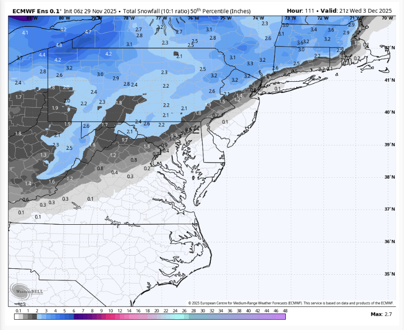
the 6z Euro is SO close for the metros. it would only take like 20 miles for them to stay. all snow. still 80 hours out...
-

First Winter Storm to kickoff 2025-26 Winter season
WxWatcher007 replied to Baroclinic Zone's topic in New England
That gives me flashbacks to last season, where it seemed like something always destructively interfered with any sw trying to amplify.


.png.ca6d6a1708312fcc53c4c4fe4100cb2f.png)


