All Activity
- Past hour
-
Most interesting part of this storm is the surface temps dropping from near freezing at onset to mid 20s during the meat. I didn't get good ratios last storm due to warmish start and temps just below freezing when it mattered. Could be a lot fluffier this go around. I like my yard for this one.
-
Really? Y'all have gotten more main courses of sliders than some of us northerners have had in 8 years!
-
can't make this up #Snowhole

-
Thanks. I asked google but prefer asking an educated person, not AI. I just received a weather alert for freezing fog in the morning and didn’t understand. I’m in Raleigh.
-
I'm telling ya this is gonna be a Miller Too Late.. I'd almost bet a 6-leg parlay on it, lol This is a nina and these kind of setups snow around us but not on us. Not even gonna give this one the time of day (unless it's Saturday night and it looks like it'll buck the trend). I'll prepare the last words of Beethoven: "Pity, pity...too late!"
-
Racing downhill, let’s go! Any hopium I can get I’ll take.
-

December 2025 regional war/obs/disco thread
Torch Tiger replied to Torch Tiger's topic in New England
https://store.steampowered.com/app/1107320/OUTBRK/ new hobbies for all -

December 2025 regional war/obs/disco thread
Sey-Mour Snow replied to Torch Tiger's topic in New England
That’s a gorgeous spot day 7 for gfs , if it had support and wasn’t the 18z gfs… -
Things always seem to slide North leaving us with the leftovers and somehow we could go 2/2 and still early December is wild. Fingers crossed for the snow day tomorrow! .
-

The Monday wintry event potential (12/8/25)
Orange county replied to GaWx's topic in Southeastern States
Freezing fog is not really a meteorological term, Pearson said. In order for it to form you need items or an object near the surface to be below freezing temperature, he said. This could include, trees, power lines and power poles, fences, tall weeds or cars. The air above the ground has supercooled water droplets in it, that might be just below freezing but are still in liquid form. Once those droplets come in contact with something at the ground or just above the ground freeze on contact with the surface of that object, Pearson said. Most often, freezing fog does accumulate on trees and power lines and if the wind is calm or maybe even light, can make a very picturesque scene as the supercooled water droplets turn into ice crystals (also called rime ice). If there is some wind, then the water droplets will just form more as a hard layer of ice vs the more crystalized picturesque rime ice. -
December 2025 regional war/obs/disco thread
Sey-Mour Snow replied to Torch Tiger's topic in New England
Or just become hurricane hunters ? -

December 2025 regional war/obs/disco thread
powderfreak replied to Torch Tiger's topic in New England
Nice snowy evening with the clipper. Should get a 2-4” refresh.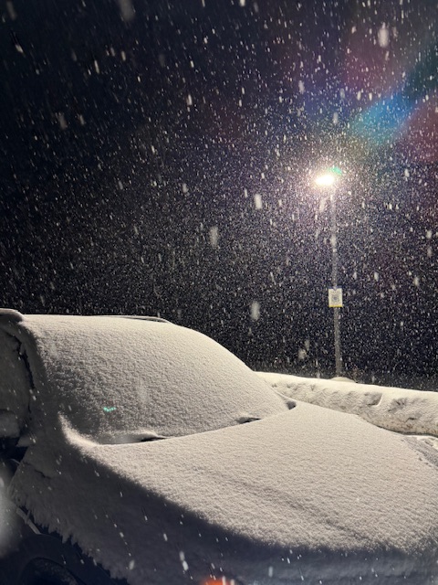
-
It’s very rare around here, which made last night so interesting but like normal fog, you have to have high humidity and that saturated air super cools into droplets. Those droplets then freeze on surface objects like freezing rain, but the main difference being that these droplets are tiny - much smaller. Think steam in a bathroom after a shower vs the water coming out of the shower itself - similar concept. It’s a lot more common in coastal communities that get cold: i.e. New England, Seattle.
-
See you in South Hill!
-
Gfs has next Sunday again. And guess what, it’s a southern Va hit lol
-

December 2025 regional war/obs/disco thread
TauntonBlizzard2013 replied to Torch Tiger's topic in New England
Yeah, people mocking it, but it’s absolutely the most likely outcome right now, and by a significant margin too. -

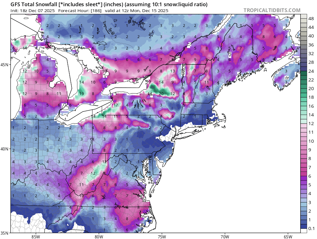
December 2025 Short/Medium Range Forecast Thread
Carvers Gap replied to John1122's topic in Tennessee Valley
I think our next trackable system is around Dec 11th - very light NE TN, SE KY, SW VA, possible Plateau. Then, I think our best chance will be around Dec 14th. As long as that cold front presses into our area w/ full force, I think we likely see frozen precip then. The 18z GFS shows the potential for that one. It is running as we speak. -
I’m trying to keep an eye on the RRFS’ performance with this one, I haven’t been watching it lately but this time I’m taking note.
-
I am going to South Hill and that vicinity tomorrow.
-
Roanoke County VA schools closed Monday.
-

The Monday wintry event potential (12/8/25)
kvegas-wx replied to GaWx's topic in Southeastern States
School closings gotta be coming soon for the Triad and northern counties, right? If they closed for Friday, this is modeled as a higher impact event during school hours. Really curious to see what WSFCS does here. -

December 2025 regional war/obs/disco thread
Snowcrazed71 replied to Torch Tiger's topic in New England
Still says past 84 hours on my end? Who's messing with me? LOL -
As I watched the final second tick on the ravens game.. I thought to myself.... Only 73 days till spring training !!!
-
Good luck ya jerks
-
December 2025 Short/Medium Range Forecast Thread
Carvers Gap replied to John1122's topic in Tennessee Valley
As for the medium and LR pattern, ensembles and deterministic modeling still favor some amplification mid-month. Whatever we get is likely going to be northern stream influence.