All Activity
- Past hour
-

2026-2027 Super El Nino
PhiEaglesfan712 replied to Stormchaserchuck1's topic in Weather Forecasting and Discussion
72-73 is the only super el nino that followed a double la nina. From the strong group, you have 09-10 following a double la nina, with 57-58 and 23-24 following a triple la nina. -

2026-2027 Super El Nino
Stormchaserchuck1 replied to Stormchaserchuck1's topic in Weather Forecasting and Discussion
The subsurface has stopped warming. It ebbs and flows though with Kelvin/Rossby waves. Here is what 1997 did: 2015 2023 -
Closest screw job i can think of like that would be Feb 2021 or the 3 big storms of the 00-01 season, pretty brutal there.
-
We took our team of students out for a field day. It was superb.
-
It seems criminal I had to work on a day like this. I think the office should declare force majeure on days like this and send everyone out to the beach.
-
he does. he has the book "Blizzard!" anyway, multiple more new snowstorms from the 1960s, 70s, 80s, and 90s have been added recently. Latest one was Mar 3-5, 1960, next im working on Feb 9-10th, 1969. i am working on more and will have a full update soon...for now every storm in the historic snowstorms archive has been updated with new maps. kinda sounds like dendie, though i dont think he actually really cares but just poking the bear. best of the best round here.
-
Works for me
-
At least we are sharing the drought with many https://bsky.app/profile/drjeffmasters.bsky.social/post/3mns5c3ypsc2k
- Today
-
Some of u
-
I have a met friend in SNH that hates when I get snow as well. I've never seen such little d*ck syndrome as that.
-
Our ability to complain about every possible weather scenario is unmatched
-

2026-2027 Super El Nino
snowman19 replied to Stormchaserchuck1's topic in Weather Forecasting and Discussion
-
6 -10 is close to normal or slightly above temp and possibly above precip for the metro as of today
-
Longest day in golfing yesterday. Apparently they’ve never played in the NH Fourball Championship. Lol 36 holes of fourball at Owl’s Nest tomorrow.
-
We still average a solid 4-5 days per week of clouds.
-
The end of the 18z HRRR also showing a well recovered powder keg of an atmosphere early afternoon Thursday. Can't imagine what 00z runs will show if trends continue
-
Our ability to have non-precipitating clouds is unmatched.
-
Shades of? https://www.weather.gov/lot/2014_06_30_SevereStorms
-
 This is especially ironic coming from someone who normally claims NOAA’s modern records are bogus, adjusted, contaminated, or otherwise untrustworthy. But a lone 105°F reading from a high-elevation northern interior New York site in 1919, with surrounding stations reporting 88–94°F on the same date, is suddenly sacred scripture? And that was literally the only substantive change I made. The rest of the map is from Martz’s own website, just reassembled to show the most recent occurrence of a given high, with a couple of corrections for omissions (Maryland & NC in 2012) and updated to include 2025's record highs(map ends in 2024). Martz himself excludes
 -
The HRRR is top tier for tomorrow around here, projecting 3 rounds of back-back-back severe clusters locally.
-

2026 Mid-Atlantic Severe Storm General Discussion
Eskimo Joe replied to Kmlwx's topic in Mid Atlantic
I would favor Friday for more organized severe weather. Thursday gives the all hat no cattle impression. -
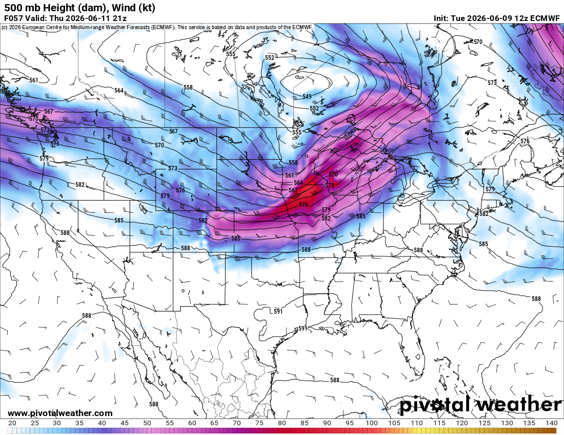
That is quite a potent shortwave on the 12z Euro for Thursday with a 90+ kt 500 mb max, especially for June. Morning convection will rule the roost as usual, but I would expect a pretty widespread and potentially significant severe event given the magnitude of the flow overlapping strong instability.

-
Funny last night for no reason I was thinking about derechos and the pronunciation It is written
-
I'm in that camp too unless it migrates west quicker and becomes more of a Modoki Nino