All Activity
- Past hour
-

November 2025 general discussions and probable topic derailings ...
SJonesWX replied to Typhoon Tip's topic in New England
i was told it was something to watch -
If indeed weak La Niña this winter? should snowfall departures be similar?
-

November 2025 general discussions and probable topic derailings ...
CoastalWx replied to Typhoon Tip's topic in New England
Too bad the block chews up a potential event next week. -
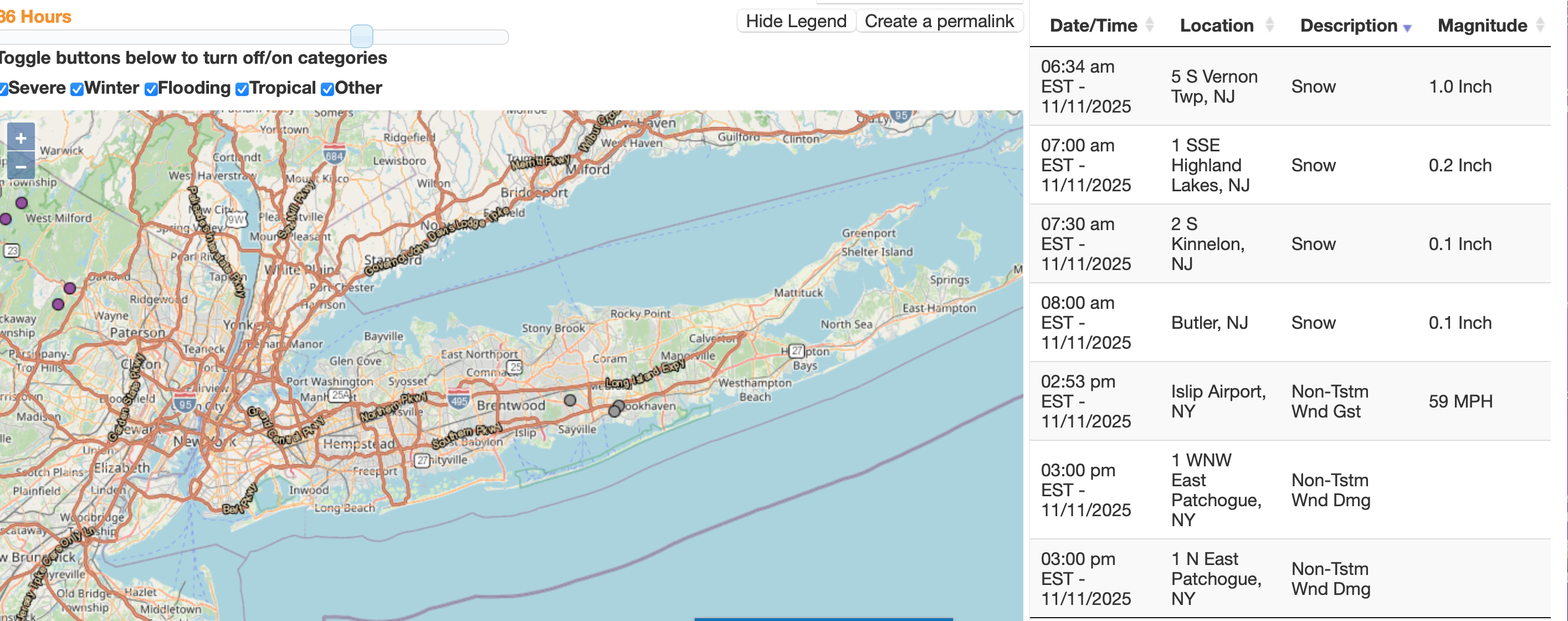
 Philly max wind gusts... 00 NOUS41 KPHI 112159 PNSPHI DEZ001>004-MDZ012-015-019-020-NJZ001-007>010-012>027-PAZ054-055-060>062-070- 071-101>106-120959- Public Information Statement National Weather Service Mount Holly NJ 459 PM EST Tue Nov 11 2025 ...HIGHEST WIND REPORTS FOR NOVEMBER 11, 2025... Location Speed Time/Date Provider ...New Jersey... ...Atlantic County... Atlantic City Airport 46 MPH 1130 AM 11/11 ASOS Atlantic City 46 MPH 1240 PM 11/11 NJWXNET 2 ESE Pleasantville 44 MPH 0150 PM 11/11 AWS BRIGANTINE 41 MPH 1117 AM 11/11 CWOP Pleasantville Point 41 MPH 1229 PM 11/11 WXFLOW ...Burlington County... Mount Holly 44 MPH 0326 PM 11/11 ASOS Moorestown 41 MPH 1255 PM 11/11 NJWXNET McGuire AFB 38 MPH 0355 PM 11/11 AWOS ...Camden County... Pennsauken 44 MPH 1200 PM 11/11 NJWXNET Blue Anchor 35 MPH 0210 PM 11/11 RAWS ...Cape May County... 1.2 NW Avalon 52 MPH 0233 PM 11/11 HADS Cape May Harbor 49 MPH 1215 PM 11/11 HADS Cape May 47 MPH 1216 PM 11/11 WXFLOW Villas 45 MPH 0405 AM 11/11 DAVIS Ocean City 41 MPH 0137 PM 11/11 WXFLOW Cape May 39 MPH 1155 AM 11/11 AWOS Dennis Twp. 39 MPH 1225 PM 11/11 NJWXNET West Cape May 38 MPH 0225 PM 11/11 NJWXNET Woodbine Muni 38 MPH 1153 AM 11/11 AWOS North Wildwood 35 MPH 1215 PM 11/11 DAVIS ...Cumberland County... Fortescue 50 MPH 1200 PM 11/11 NJWXNET Millville 46 MPH 0208 PM 11/11 ASOS Upper Deerfield 40 MPH 0125 PM 11/11 NJWXNET Bivalve 37 MPH 1139 AM 11/11 HADS Greenwich 37 MPH 0327 PM 11/11 HADS ...Gloucester County... Kingsway Regional HS 42 MPH 1150 AM 11/11 MESOWEST Logan Twp. 35 MPH 0130 PM 11/11 NJWXNET ...Mercer County... Trenton 43 MPH 0203 PM 11/11 ASOS ...Middlesex County... Perth Amboy 43 MPH 0134 PM 11/11 WXFLOW Deans 36 MPH 1010 AM 11/11 RAWS 1 NNW Yorketown 36 MPH 0254 PM 11/11 AWOS South Amboy 35 MPH 0255 PM 11/11 DAVIS ...Monmouth County... 1.0 NW Keansburg 45 MPH 0139 PM 11/11 HADS Belmar Farmdale 43 MPH 0214 PM 11/11 AWOS SEA BRIGHT 43 MPH 0305 PM 11/11 CWOP Sea Girt 41 MPH 0105 PM 11/11 NJWXNET Monmouth 40 MPH 0153 PM 11/11 WXFLOW Cream Ridge 37 MPH 0135 PM 11/11 NJWXNET Oceanport 35 MPH 0140 PM 11/11 NJWXNET ...Morris County... Randolph 40 MPH 0325 PM 11/11 CWOP Morristown 35 MPH 1245 PM 11/11 AWOS ...Ocean County... Beach Haven 51 MPH 0216 PM 11/11 CWOP Mantoloking 49 MPH 0146 PM 11/11 WXFLOW Rutgers 49 MPH 1202 PM 11/11 WXFLOW Harvey Cedars 47 MPH 0150 PM 11/11 NJWXNET North Beach Haven 46 MPH 0105 PM 11/11 CWOP Tuckerton 45 MPH 1233 PM 11/11 HADS North Beach 42 MPH 1115 AM 11/11 DAVIS Seaside Heights 42 MPH 0209 PM 11/11 WXFLOW Toms River 41 MPH 0107 PM 11/11 AWOS Surf City 40 MPH 0115 PM 11/11 CWOP South Seaside Park 39 MPH 0129 PM 11/11 CWOP Brick 38 MPH 1225 PM 11/11 DAVIS Seaside Park 38 MPH 0315 PM 11/11 CWOP Trixies 38 MPH 0125 PM 11/11 WXFLOW Long Beach Township 37 MPH 0125 PM 11/11 DAVIS Berkeley Twp. 36 MPH 1210 PM 11/11 NJWXNET Ship Bottom 35 MPH 0330 PM 11/11 CWOP ...Salem County... Mannington Twp. 35 MPH 0325 PM 11/11 NJWXNET ...Somerset County... Somerville 35 MPH 0246 PM 11/11 ASOS ...Sussex County... High Point Monument 43 MPH 0140 PM 11/11 NJWXNET ...Warren County... Blairstown 37 MPH 1239 PM 11/11 AWOS Stewartsville 36 MPH 0135 PM 11/11 NJWXNET ...Pennsylvania... ...Berks County... Reading 45 MPH 0110 PM 11/11 ASOS Hopewell 43 MPH 0143 PM 11/11 RAWS LENHARTSVILLE 42 MPH 0315 PM 11/11 CWOP 2 WSW Hamburg 38 MPH 1010 AM 11/11 PADOT Sinking Spring 35 MPH 0113 PM 11/11 CWOP ...Bucks County... Burlington NOS 40 MPH 1224 PM 11/11 NOS-PORTS Doylestown 40 MPH 1240 PM 11/11 ASOS Newbold NOS 39 MPH 0300 PM 11/11 NOS-PORTS Kintnersville 38 MPH 1245 PM 11/11 CWOP Nockamixon 38 MPH 1043 AM 11/11 WXFLOW Perkasie 38 MPH 1235 PM 11/11 AWOS ...Chester County... White Clay Creek West Grove- 46 MPH 1150 AM 11/11 DEOS2 Coatesville 43 MPH 0315 PM 11/11 AWOS West Chester 43 MPH 0340 PM 11/11 AWOS Marsh Creek 41 MPH 1055 AM 11/11 WXFLOW Octoraro Creek Atglen 40 MPH 1150 AM 11/11 DEOS2 1 ESE West Sadsbury Twp 38 MPH 1225 PM 11/11 PADOT Cochranville 37 MPH 0239 PM 11/11 CWOP Oxford 36 MPH 1215 PM 11/11 CWOP Kimberton 35 MPH 0205 PM 11/11 DAVIS Red Clay Creek Kennett Squar 35 MPH 0105 PM 11/11 DEOS2 ...Delaware County... Upper Chichester 35 MPH 1215 PM 11/11 CWOP ...Lehigh County... Lehigh Valley Intl Airport 45 MPH 1054 AM 11/11 ASOS Queen City 44 MPH 1235 PM 11/11 AWOS Trexler 41 MPH 1143 AM 11/11 RAWS Macungie 39 MPH 1240 PM 11/11 CWOP New Tripoli 36 MPH 0110 PM 11/11 CWOP COOPERSBURG 35 MPH 1130 AM 11/11 CWOP ...Monroe County... Mt. Pocono 43 MPH 0825 PM 11/10 ASOS Wind Gap 36 MPH 0850 PM 11/10 PADOT ...Montgomery County... 1 SE Fort Washington 43 MPH 0125 PM 11/11 PADOT Philly Wings Field 39 MPH 0115 PM 11/11 AWOS Pottstown 39 MPH 0109 PM 11/11 ASOS Willow Grove 37 MPH 0200 PM 11/11 CWOP King Of Prussia 35 MPH 1125 AM 11/11 CWOP ...Northampton County... BATH 36 MPH 1021 AM 11/11 CWOP CATASAUQUA 36 MPH 1253 PM 11/11 CWOP ...Philadelphia County... Philadelphia Northeast 53 MPH 0214 PM 11/11 ASOS 1 SSE South Philadelphia 52 MPH 0210 PM 11/11 PADOT Philadelphia International 47 MPH 1154 AM 11/11 ASOS ...New Jersey... ...Maritime Stations... Sea Isle City 47 MPH 1245 PM 11/11 HADS 1.1 N Margate City 38 MPH 1257 PM 11/11 HADS &&
 -
Not sure international returns? Think you have to take that absurd contraption back to the cattle call customs line.
-
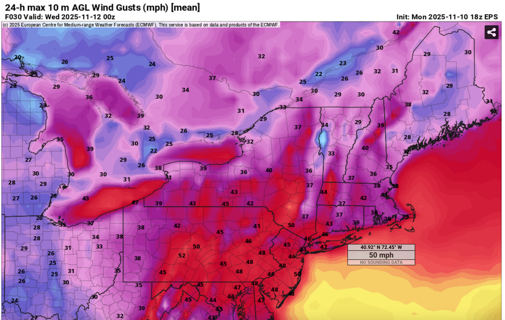
This was the EPS max gust tool from the 18z/10 (Monday) cycle for Tue. You can match with the wind gust reports. I added some LSR's as well. If interested click for clarity
-
Meh - they are quirky and fun. Not sure what the better option is... IIRC you can already walk or take the mini-subway they have in most cases but it's a longer journey.
-

November 2025 general discussions and probable topic derailings ...
ineedsnow replied to Typhoon Tip's topic in New England
We snow! -
High skill is like the last 3 days, lol. But hey, it is not usually that bad with the end result.
-
November 2025 general discussions and probable topic derailings ...
CoastalWx replied to Typhoon Tip's topic in New England
Maybe. But timing of CME and clouds might make it meh. -
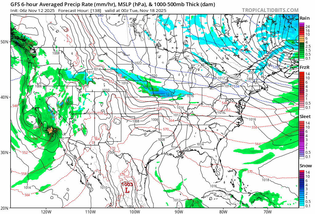
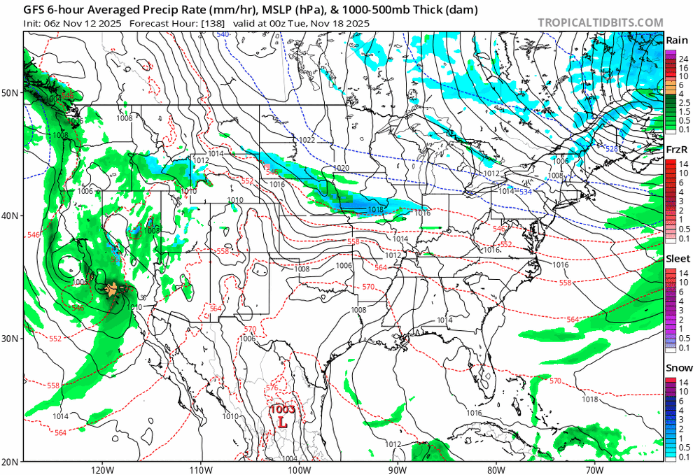
06z GFS still has the Nov 18-20 event. Doesn't look like anything big but Something interesting to watch
-
Feb 06 was a good month in CNJ, 20.5", 89/90 stunk, but teased us with a Nov snowstorm.
-
Yup PNA is king south of New England. NYC's not reaching 4" for December if that western trough hangs out for the entirety of the month. That pretty much guarantees a BN winter for us. Forgot who said it but 19" is likely a (generous) upper bound for our snow totals this winter.
-
Non-political post here…I have never agreed more with “Trump officials”
-

November 2025 general discussions and probable topic derailings ...
NoCORH4L replied to Typhoon Tip's topic in New England
Better Aurora tonight maybe? -
It was basically just one squally period that left .2. At one point it was coming down hard enough to coat the edge of low traffic streets.
-
My driveway runs adjacent to my house, facing due east. Creates a bit of a wind tunnel with my neighbors garage. In the winter and fall, leaf piles and snow drifts end up in the same place: along but a few feet away from where the wall meets the driveway.
-

Central PA Fall Discussions and Obs
Itstrainingtime replied to ChescoWx's topic in Upstate New York/Pennsylvania
35 at 11pm last evening, 40 at 7am when I left for work today. -
For all the hype of this cold blast...it was never really anything but a normal cold blast for November in Raleigh. Back when I was a kid we got our first freeze here in October pretty much every year.
-
I might want to actually try and win this, so here are updated totals: BWI: 21.4" DCA: 15.5" IAD: 24.7" RIC: 9.6" ----- SBY: 8.5"
-

November 2025 general discussions and probable topic derailings ...
Typhoon Tip replied to Typhoon Tip's topic in New England
Large scale changes in the circulation mode of the Pacific are emerging in both the operational prediction methods, and experimentals. It is way out there in time. We won't get too crazy. That does imply standard challenges to confidence, but relative to typical predictive skill at extended leads for pattern evolution, this is above normal. There are compelling signals nearing and post TG. Those go beyond just numerical indexes, too. They're related to zonal wind structural collapse at very high altitudes ( around 60 N) over Siberia, unzipping around globe toward the the Alaskan sector. That can be associated with Sudden Stratospheric Warming event. However ... I suspect what is happening in the guidance is the other way around. An exceptionally loud upper level ridge signal may be emerging in time. These big-time N-NE Pacific ridge blossoms can lift heights and ultimately the jet latitude S far N, forcing the mean polar vortex to 'kidney bean' around. The model zonal wind collapse is the top of ridge - think of it like a stationary cap cloud over a mountain top... it exposes how the wind bumps around the obstacle beneath quite high. Interestingly, it can be a prelude to an SSW too - that's a longer discussion but I suspect that is worth watching for (SSW) later in December. Meanwhile, all three, EPS/GEFS/CEFS ensemble systems are drilling both the West Pacific and East Pacific Oscillation indexes negative on and after Thanks Giggedy. This is also nicely painted in the spatial synoptic charts. They are all clearly reconstructing the Pacific; there is even evidence of an HC recession, with lowering heights beneath 40 N between Japan and N of Hawaii. That's a regression in low latitudes that would typically herald a ridge response over the NE Pacific and Alaska. Those latter telecons and synoptic arguments are perfectly timed. SO, there are multiple methodology converging on a signal for Pacific changes, changes which btw are canonical preludes to continental cold loading. We may also have to contend ( ha, "contend" - some people want it ) with a warm up E of 100W across the continent. The NAO probably loses the non-linear support for it's existence and starts to disappear as these aforementioned changes are emerging. - Today
-
While low temperatures were kind of 'meh' this week, we won big time on day time departures. Yesterday's high of 45 degrees at BWI was 14 degrees below normal.
-

November 2025 general discussions and probable topic derailings ...
GCWarrior replied to Typhoon Tip's topic in New England
. -
I would say potentially yes - the prior two may have "cleared the way" for this one. However, if it arrives too early it might not be well-timed with daylight/night.
-

2025-2026 ENSO
donsutherland1 replied to 40/70 Benchmark's topic in Weather Forecasting and Discussion
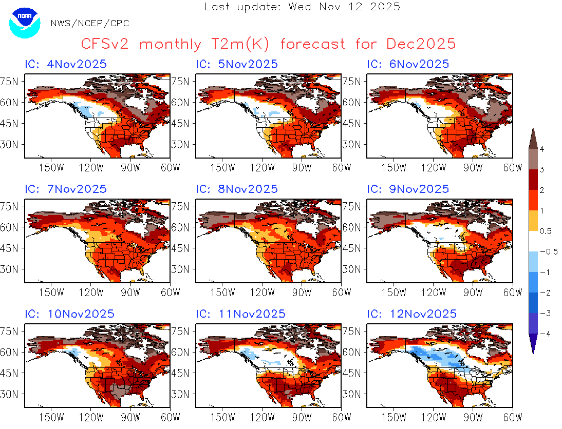
Here's the evolution of the CFSv2 forecast for December. It should be noted that all the timeframes, the CFSv2 is not yet in its high skill area.