All Activity
- Past hour
-

2025-2026 ENSO
40/70 Benchmark replied to 40/70 Benchmark's topic in Weather Forecasting and Discussion
I post in on my blog and then copy and past as a work around to this forum's limitations. -
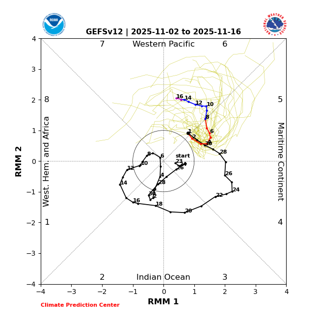
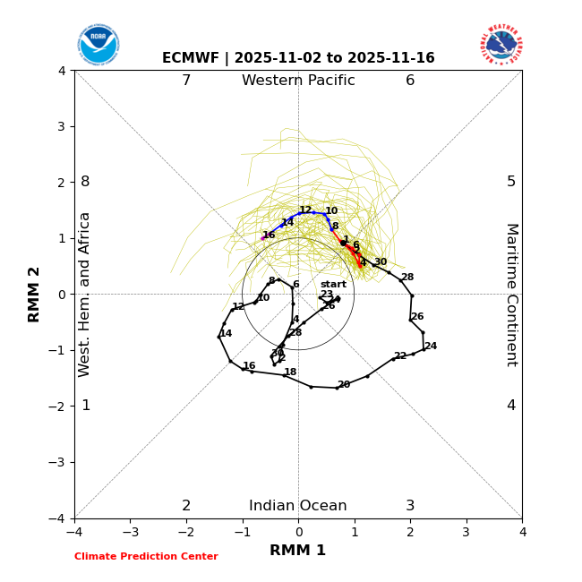
We’ll see. Latest MJO forecasts: 1. GEFS, which has been doing much better than EPS as is often the case in this part of the diagram: slowly headed to strong 6 in direction of strong 7 2. EPS: headed to moderate 7:
-
2025-2026 ENSO
40/70 Benchmark replied to 40/70 Benchmark's topic in Weather Forecasting and Discussion
I will say, February 2008 was much higher amplitude in the MC, but not the case in the other months -

Central PA Fall Discussions and Obs
Itstrainingtime replied to ChescoWx's topic in Upstate New York/Pennsylvania
Probably the best I've watched since the 1975 series. Nothing compares to that. But this one is right up there vying for #2 with a few others. -
Unfortunately, it was just strong enough in the 5-7 phases last February to really pump the Southeast ridge and force the best snows up closer to Toronto. We got the classic weakening before 8 which has been common since February 2022. Even when we got the phase 8 in March 2023, it favored the higher elevations of the Northeast for the best snows.
-

November 2025 general discussions and probable topic derailings ...
ineedsnow replied to Typhoon Tip's topic in New England
Looks like the 12Z ICON would of had some snow next Sunday night -
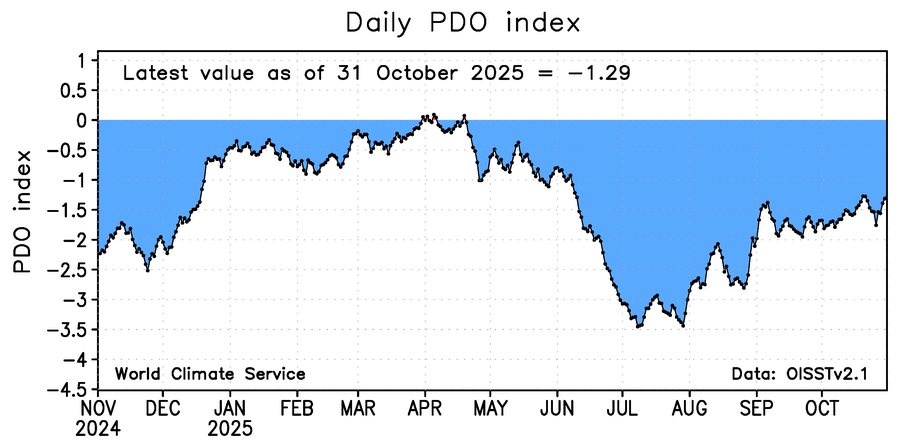
One year ago today the daily WCS daily PDO was ~-2.25. On 10/31/25, it was -1.29:
-
 I look back at these sensor wind gusts... Just seemed to me much more power outages, normally associated with somewhat higher gusts. Need a study of wind gusts with soil moisture, leaf status, direction (east vs nw or w)
 -

November 2025 general discussions and probable topic derailings ...
powderfreak replied to Typhoon Tip's topic in New England
We had a high of 44F yesterday and start +2 lol. -
2025-2026 ENSO
40/70 Benchmark replied to 40/70 Benchmark's topic in Weather Forecasting and Discussion
Now, maybe the west warm pool changes that? We will have to see. -
2025-2026 ENSO
40/70 Benchmark replied to 40/70 Benchmark's topic in Weather Forecasting and Discussion
I'm glad that you clarified exactly what you were insinuating with these nebulous -IOD inferences. I am going to post my outlook either this weekend or more likely early next week and will look into this a great deal since ENSO in and of itself is pretty clear. It seems like you are implying that this weak east-central based event will act like a Modoki event because of the -IOD? I don't have an issue with that in a vacuum, since other factors easily overwhelm the Modoki index when ENSO is weak, however, if you look back at 2008, which you have compared this -IOD event to on several occasions, that did not happen. And that event actual was Modoki. It made it to phase 7 in December, all the way around in January and even kissed phase 8 again briefly in February before hitting phase 8 again at high amplitude in March. -
Some mountains blowing the snow this AM.
-

November 2025 general discussions and probable topic derailings ...
kdxken replied to Typhoon Tip's topic in New England
Yeah rain and temps in the forties and low '50s I consider cold. Worcester - 2.1 to start the month. -
BWI: 21.0” DCA: 10.0” IAD: 16.7” RIC: 6.8” Tiebreaker: LYH: 11.2”
-
I have the same issue with my ambient. In the afternoon, the radiation shield has the suns shadow cast over it by the weather station itself. But in the early mornings and late afternoons, the sun is shining on the radiation shield head-on, so you see a temp spike.
-
 Low of 29.5° at WXW1
 -
2025-2026 ENSO
40/70 Benchmark replied to 40/70 Benchmark's topic in Weather Forecasting and Discussion
December 1995 was pretty strong, too. -
BWI: 13.1” DCA: 8.2” IAD: 12.8” RIC: 5.9” Tiebreaker SBY: 6.1”
-
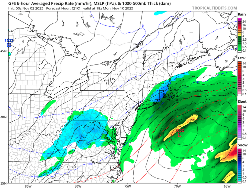
 Euro & GFS say keep an eye around the 10th? Both also brew up a beast for center part of country around the 17th.
 -
34.2. Some colder spots near me dipped below 32. Second frost here
-
Blue pixels keep showing up around the 10th. Hoping to get some upslope snow
-
Dry Novembers have become the norm here. Only 3 of the last 18 have finished above the long-term average of 2.73” (2011, 2018, 2022) Average of those 18 seasons is 2.05”
- Today
-

Central PA Fall Discussions and Obs
canderson replied to ChescoWx's topic in Upstate New York/Pennsylvania
Toronto choked and I’m still about it! -
BWI: 15.4” DCA: 11” IAD: 16.8” RIC: 7” TB LYH: 11”
-
Wind adv out for today for strong SW winds. Leaves are blowing around pretty good. Last few days, lots of tweety flocks, and even a few geese flocks moving through.


