All Activity
- Past hour
-

2025-2026 ENSO
40/70 Benchmark replied to 40/70 Benchmark's topic in Weather Forecasting and Discussion
It would probably be a pattern that would still stack snow in NNE, but my area points southward would struggle on the cp. -

2025-2026 ENSO
40/70 Benchmark replied to 40/70 Benchmark's topic in Weather Forecasting and Discussion
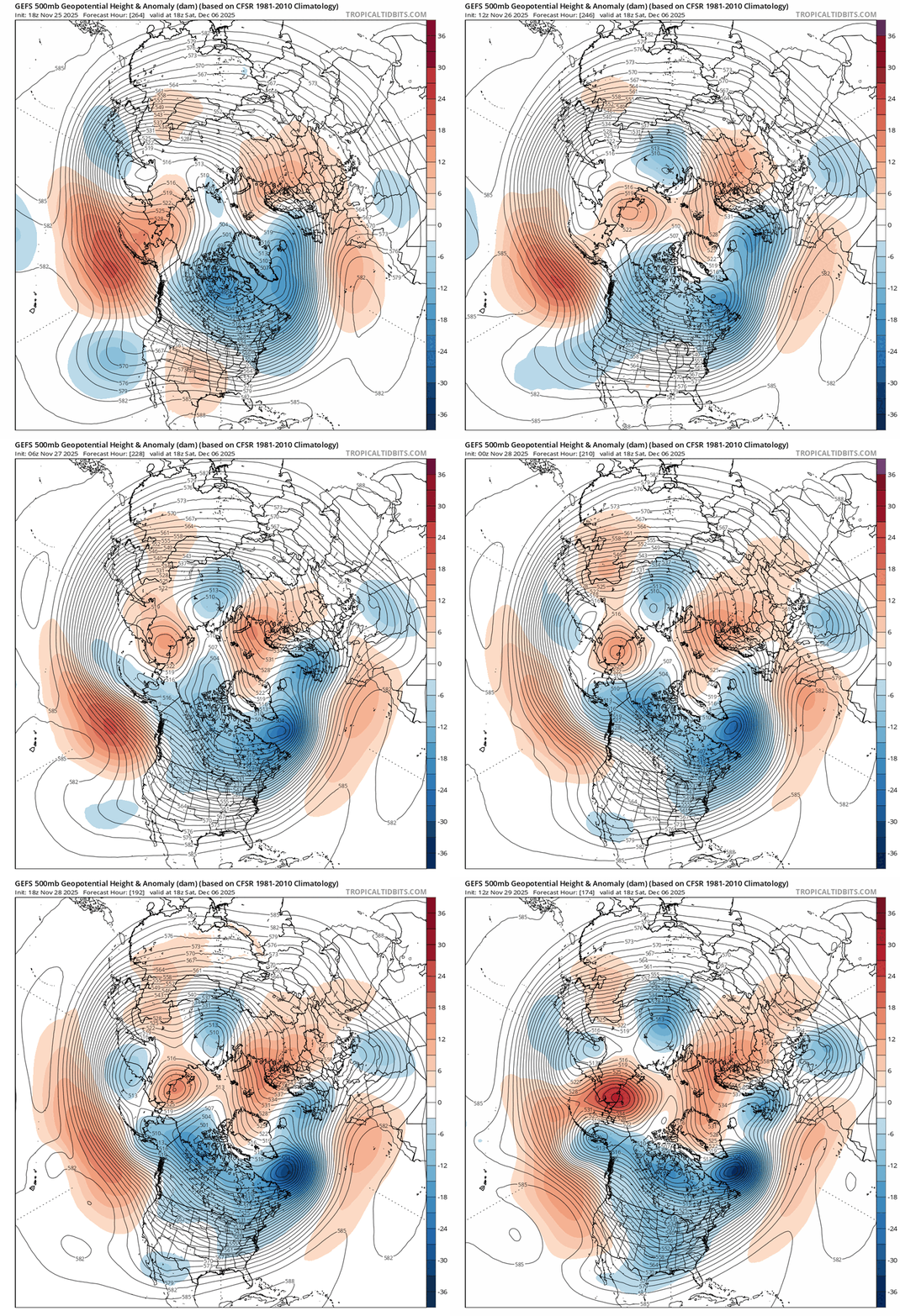
Yea, the cold 500mb is what I was getting at by "cold in se Canda", which I was supremely confident would be in play this year, in sharp contrast to the past decade. -

Central PA Fall Discussions and Obs
GrandmasterB replied to ChescoWx's topic in Upstate New York/Pennsylvania
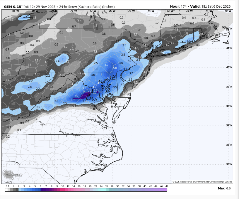
Ukie has measurable down to the MD line. My goal for this system (IMBY) is two inches. Seems plausible at this time. -

2025-2026 ENSO
40/70 Benchmark replied to 40/70 Benchmark's topic in Weather Forecasting and Discussion
I still think there will be some sort of break prior to Xmas....also not huge on mid atlantic snowfall this month...at least not in the lower terrain on the coastal plane. -

2025-2026 ENSO
Stormchaserchuck1 replied to 40/70 Benchmark's topic in Weather Forecasting and Discussion
It may just be a brief pattern though, like a few days. I think 36 hours ago the ensemble mean had the coldest anomalies over the PNW, where it's now Alaska so it's been moving around a little bit. A +EPO can overwhelm +PNA/-NAO.. btw, NAO is SLP between ~Iceland and the Azores. That's +NAO being shown, but -AO (High pressure over the arctic circle). Not really a strong anomaly pattern coming up.. hard to make a forecast in all that neutrality. I do like the overall cold 500mb in the N. Hemisphere though. -

Nov 28-30th Post Turkey Day Winter Storm
sbnwx85 replied to Chicago Storm's topic in Lakes/Ohio Valley
1/4 mile visibility at South Bend. Snow Freezing Fog 26°F -3°C Humidity 92% Wind Speed SE 13 mph Barometer 30.34 in (1028.7 mb) Dewpoint 24°F (-4°C) Visibility 0.25 mi Wind Chill 15°F (-9°C) Last update 29 Nov 11:54 am EST -

2025-2026 ENSO
brooklynwx99 replied to 40/70 Benchmark's topic in Weather Forecasting and Discussion
if a transient AK vortex does develop, it would be due to a strongly negative WPO… you’d be getting modified Siberian air, not a true Pacific onslaught sure, you’d modify eventually, but it wouldn’t be all that bad -

Nov 28-30th Post Turkey Day Winter Storm
RCNYILWX replied to Chicago Storm's topic in Lakes/Ohio Valley
Legit SN to +SN out here in my part of Naperville (near DuPage Will border). Sent from my SM-S936U using Tapatalk -
Nov 28-30th Post Turkey Day Winter Storm
ChiTownSnow replied to Chicago Storm's topic in Lakes/Ohio Valley
Shhhhhhhh.... -
First Winter Storm to kickoff 2025-26 Winter season
dryslot replied to Baroclinic Zone's topic in New England
GYX .LONG TERM /SUNDAY NIGHT THROUGH FRIDAY/... Overview: Low pressure lifting into the Canadian Maritimes will drag a cold front across the area Sunday night into Monday morning. High pressure builds in from the west and crests over the area Monday night. A progressive area of low pressure will track near southern New England Tuesday afternoon into Wednesday morning bringing accumulating snow to much of the area. High pressure builds in late Wednesday followed by an Arctic cold front crossing Thursday. Impacts: *The Tuesday evening commute likely see impacts from accumulating snowfall that could linger into Wednesday morning, particularly across the southern half of the area. Much of the forecast area south of the mountains will see the potential for several inches of accumulating snow starting around mid day Tuesday and lasting into Wednesday morning. Global models are in general agreement in the synoptic setup with a low amplitude trough lifting NE across the Mid Atlantic towards southern New England Tuesday night. However, subtle differences in the latitude and sharpness of the trough has resulted in a spread in the track and amplification of the surface low amongst deterministic guidance. A look at ensembles shows somewhat better agreement with loose clustering of low centers tracking near 40N/70W Tuesday evening. The lack of upstream blocking will lead to the surface low progressing ENE south of Nova Scotia by early Wednesday morning. This track will favor mostly snow with DESI showing probabilities of greater than 3 inches along and south of the foothills around 50-60 percent. The parent trough to this system is currently in the Gulf of Alaska and will move onshore within better sampling of RAOBs some time late tonight into Sunday. This will bear watching over the coming days as the more amplified solutions will bring the potential for near Warning level snowfall if they were to verify. Low pressure quickly exits into the Canadian Maritimes Wednesday afternoon with high pressure briefly building in from the southwest. High pressure will be suppressed south Thursday as an Arctic cold front takes aim at northern New England. -

Central PA Fall Discussions and Obs
GrandmasterB replied to ChescoWx's topic in Upstate New York/Pennsylvania
I’m not putting a lot of weight on the 78 hour NAM thermals. Could certainly end up being right, but it’s not close to the euro output. -
Nov 28-30th Post Turkey Day Winter Storm
DocATL replied to Chicago Storm's topic in Lakes/Ohio Valley
My post traumatic winter storm bust syndrome driven bittercast of 4 inches for Naperville is going to get surpassed in an hour or two. I’m sorry I let everyone down. -
When doesn’t it? Think it showed ice in July
-
If the +EPO/AK vortex happens then yea, it’s eventually going to scour out the arctic cold from Canada and the CONUS and we’re going to get Pacific origin air. The +PNA and -NAO would prevent it from getting really warm in the east, but since we are at the mercy of the PAC, the -NAO block would trap the PAC air underneath
-

First Winter Storm to kickoff 2025-26 Winter season
weatherwiz replied to Baroclinic Zone's topic in New England
The storm but I also think I could get into that range. I think a lot would have to go right to really get a widespread area of 6-7-8-9” or so. But depending on how this evolves there could room for those higher totals a bit farther north into parts of NH -

First Winter Storm to kickoff 2025-26 Winter season
CoastalWx replied to Baroclinic Zone's topic in New England
I have Sarah Maclachlan playing on the blue tooth speaker. -

2025-2026 ENSO
brooklynwx99 replied to 40/70 Benchmark's topic in Weather Forecasting and Discussion
quite the trend with the AO… almost getting a -WPO/-NAO ridge bridge at this point. makes sense with the weak SPV -
The 12/5/2002 snowfall was a gem.
-

First Winter Storm to kickoff 2025-26 Winter season
moneypitmike replied to Baroclinic Zone's topic in New England
Are you saying for your backyard or that's the ceiling for the storm? -
First Winter Storm to kickoff 2025-26 Winter season
dryslot replied to Baroclinic Zone's topic in New England
Going to jump off the ladder? -
Looks like the real thing.
-
First Winter Storm to kickoff 2025-26 Winter season
dryslot replied to Baroclinic Zone's topic in New England
I had mentioned 4-8" to a few the other day, No need to change that right now. -

First Winter Storm to kickoff 2025-26 Winter season
CoastalWx replied to Baroclinic Zone's topic in New England
I’m cleaning my gutters. Should I just end it all? -
I don't buy the +EPO with MJO going in phase 8 along with the weak polar vortex. I do think a +PNA is coming.
-


