All Activity
- Past hour
-

November 2025 general discussions and probable topic derailings ...
CoastalWx replied to Typhoon Tip's topic in New England
At least the models are out an hour earlier so we can end any hope for snow an hour earlier. -
Cmc


-

November 2025 general discussions and probable topic derailings ...
MJO812 replied to Typhoon Tip's topic in New England
Cmc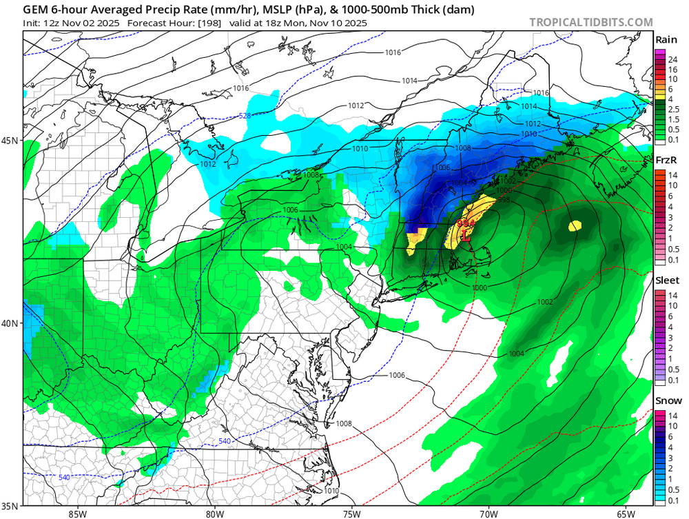


-
it feels very nice outside does not feel cool at all with the light wind been awhile since he had a day with a light wind..
-
In particular, when November sees no measurable snowfall then December goes on to see below average snowfall during a La Niña, it very strongly corresponds to a below to well below average season. Obviously not 100% and I’m sure people can find exceptions to that rule over the course of 100+ years of weather record keeping, but as a sweeping generality it works very well
-
Wintry threats are certainly possible in November but very unlikely Then again with how bad winters have been, any month is unlikely
-
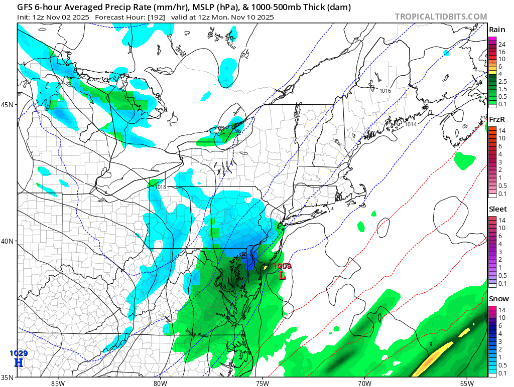
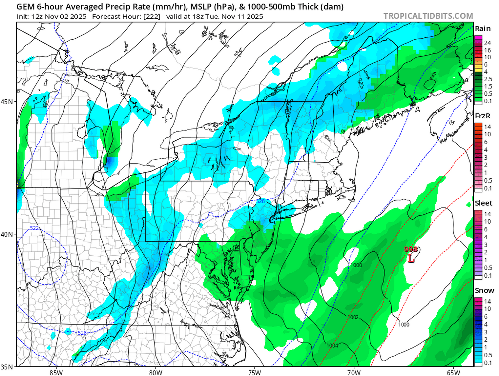
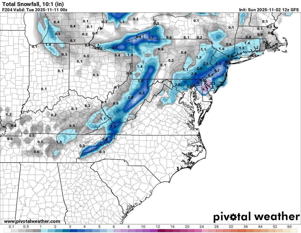
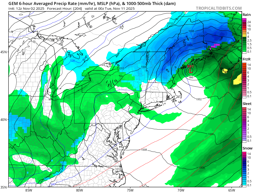
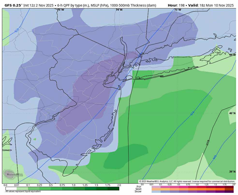
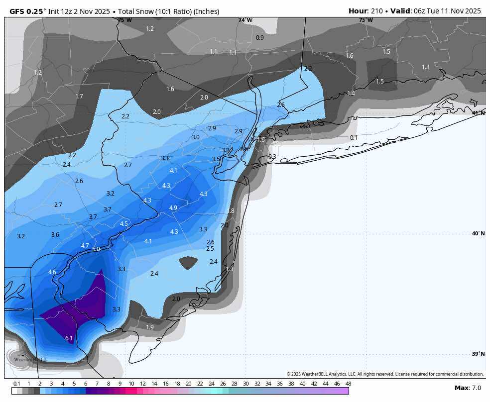
ICON has the Nov 10 threat too. I will almost always "sell" a wintry threat near the coast this early in the season unless it's modeled in the short term. But what I'm happy to see on guidance is maybe the first decent Canadian-cold delivery of the early season. If wave timing is ideal, it's the kind of scenario that could whiten elevated NEPA, southern tier of NY, Catskills, Berks etc.
-
EPS, GEFS, and GEPS all have a semblance of a wintry threat centered on November 10, plus or minus a day. It's been there for a few cycles now. All the usual caveats apply. Far inland, elevated spots look to have a decent chance of flakes over the next 10 days or so. That seems fairly consistent with historical norms.
-
The December level for snowfall at NYC, EWR, and LGA is 4”. There have been 15 La Niña winters between 95-96 and 24-25. The December 4” snowfall indicator has correctly worked 14 out of 15 times. The under 4” December snowfall last winter was a good early indicator for the rest of the season at the 3 stations for a below average finish. This must be due to La Ninas being frontloaded in nature and December showing the seasonal pattern early. The only time it didn’t work was the 16-17 La Niña. For Decembers with under 4” at those stations the seasonal totals went on to finish below average. For the Decembers with more than 4” during La Ninas the seasons finished above average snowfall. So a 93% success rate between 95-96 and 24-25. OCT to APR Monthly Total Snowfall for NY CITY CENTRAL PARK, NY Click column heading to sort ascending, click again to sort descending. 2024-2025 0.0 0.0 2.8 3.0 7.1 0.0 0.0 12.9 2022-2023 0.0 0.0 T T 2.2 0.1 0.0 2.3 2021-2022 0.0 T 0.2 15.3 2.0 0.4 0.0 17.9 2020-2021 0.0 0.0 10.5 2.1 26.0 T 0.0 38.6 2017-2018 0.0 T 7.7 11.2 4.9 11.6 5.5 40.9 2016-2017 0.0 T 3.2 7.9 9.4 9.7 0.0 30.2 2011-2012 2.9 0.0 0.0 4.3 0.2 0.0 0.0 7.4 2010-2011 0.0 T 20.1 36.0 4.8 1.0 T 61.9 2008-2009 0.0 T 6.0 9.0 4.3 8.3 T 27.6 2007-2008 0.0 T 2.9 T 9.0 T 0.0 11.9 2005-2006 0.0 T 9.7 2.0 26.9 1.3 0.1 40.0 2000-2001 T 0.0 13.4 8.3 9.5 3.8 0.0 35.0 1999-2000 0.0 0.0 T 9.5 5.2 0.4 1.2 16.3 1998-1999 0.0 0.0 2.0 4.5 1.7 4.5 0.0 12.7 1995-1996 0.0 2.9 11.5 26.1 21.2 13.2 0.7 75.6
-


-
BWI: 11.8" DCA: 10.7" IAD: 12.8" RIC: 5.4" Tiebreaker (LYH): 6.6" MBY: 115"
-
GFS interesting again. I’d chase that Monday and just take it off since Tuesday is a federal holiday. Let’s see what happens.
-
Solid post
-
Gfs lol
-
Jay on since yesterday… .
- Today
-

E PA/NJ/DE Autumn 2025 Obs/Discussion
The Iceman replied to PhiEaglesfan712's topic in Philadelphia Region
Lock it in
-
34 here
-
Is the PDO weaker negative than last year at this time yes. But the La Niña is much better established this time around than last year, which was a late bloomer Niña…cooler Nino region SSTs, EWBs/enhanced trades started earlier this year, the eastern PAC (GOA, along the west coast of NA and down to Baja) is cooler and there is a very pronounced -PMM (very supportive of Nina) whereas last year we had a +PMM at this time. Also, much deeper and well established +SOI and a deeply negative AAM (Nina). Would love to see what the MEI is but that doesn’t update anymore @GaWx Edit: The deeply negative -IOD speaks for itself as far as being very supportive of La Niña/constructive interference
-
The Davis doesn’t really have a problem like that. Its built in radiation shield is very effective.
-
Since this 10/28/25 post, I got another 0.05” to give me a total of 2.80” of rainfall in October. That’s only modestly below normal. This area ended up 2F BN, coolest Oct since 2022 and second coolest Oct since 2011.
-

2025-2026 ENSO
40/70 Benchmark replied to 40/70 Benchmark's topic in Weather Forecasting and Discussion
I post images on my blog and then copy and past as a work around to this forum's limitations. -
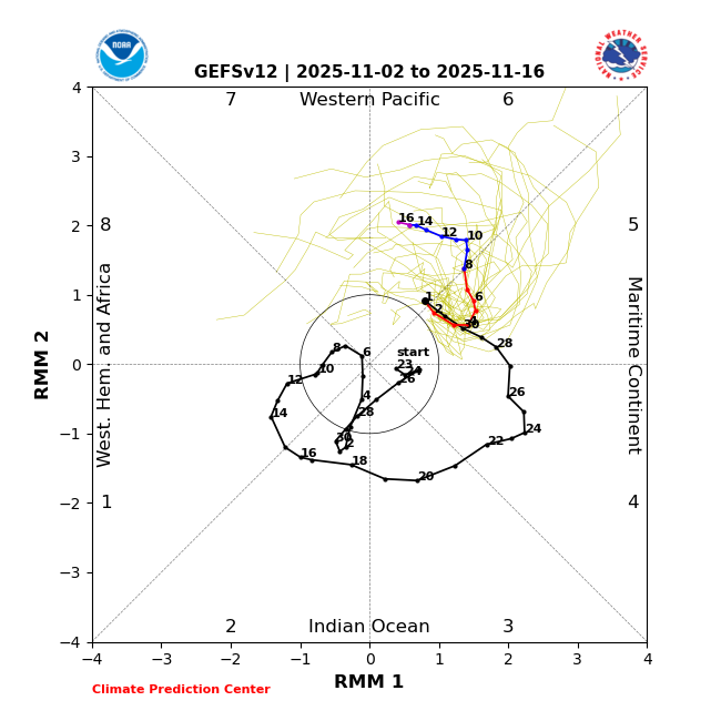
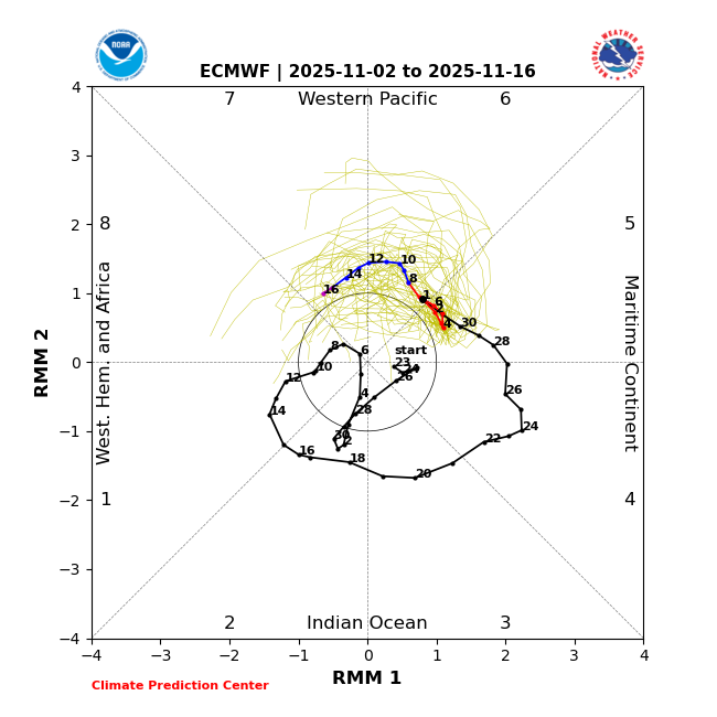
We’ll see. Latest MJO forecasts: 1. GEFS, which has been doing much better than EPS as is often the case in this part of the diagram (10/20-3 GEFS runs had today in moderate 5/6 while EPS was a fail with inside circle): slowly headed to strong 6 in direction of strong 7 2. EPS: headed to moderate 7:
-
2025-2026 ENSO
40/70 Benchmark replied to 40/70 Benchmark's topic in Weather Forecasting and Discussion
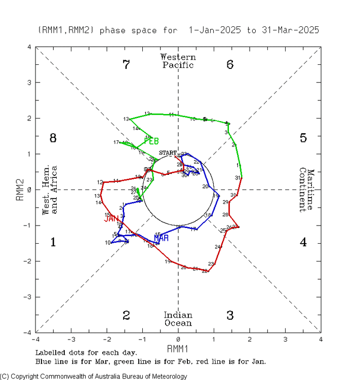
I will say, February 2008 was much higher amplitude in the MC, but not the case in the other months -

Central PA Fall Discussions and Obs
Itstrainingtime replied to ChescoWx's topic in Upstate New York/Pennsylvania
Probably the best I've watched since the 1975 series. Nothing compares to that. But this one is right up there vying for #2 with a few others. -
Unfortunately, it was just strong enough in the 5-7 phases last February to really pump the Southeast ridge and force the best snows up closer to Toronto. We got the classic weakening before 8 which has been common since February 2022. Even when we got the phase 8 in March 2023, it favored the higher elevations of the Northeast for the best snows.


.thumb.JPG.418e8a9a2902ae687ec35ff4bc0e038e.JPG)