All Activity
- Past hour
-

First Winter Storm to kickoff 2025-26 Winter season
Damage In Tolland replied to Baroclinic Zone's topic in New England
Even TH down in the dumps over the bust . Everyone is hurting
-

First Winter Storm to kickoff 2025-26 Winter season
qg_omega replied to Baroclinic Zone's topic in New England
-

December 2025 regional war/obs/disco thread
WxWatcher007 replied to Torch Tiger's topic in New England
Agree. I think we're in good shape this year. Will try to take a look at your forecast whenever I can find the time. I know you put an enormous amount of work it in. You should be proud (though I know that one never feels good until the forecast verifies). -

12/3 Snow/Sleet/Mix Bag of Everything Discussion/OBS
Chief83 replied to Mikeymac5306's topic in Philadelphia Region
Worcester, PA was down to 25.2 a few minutes ago. 26 at this moment. Still pretty clear our with a bright moon. I expect we will pop up when the clouds move in. -
(002).thumb.png.6e3d9d46bca5fe41aab7a74871dd8af8.png)
12/3 Snow/Sleet/Mix Bag of Everything Discussion/OBS
ChescoWx replied to Mikeymac5306's topic in Philadelphia Region
For those on Team Snow - I present the latest European AI model ensemble means run....the best weenie run I can find - so you mean there is a chance??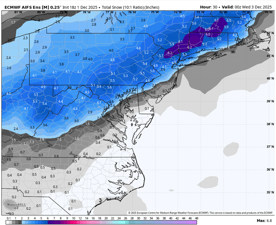
-
December 2025 regional war/obs/disco thread
WxWatcher007 replied to Torch Tiger's topic in New England
That sounds like absolute hell. That's one situation where I'd rather not even have a storm in the area. Keep it cold and dry. -

First Winter Storm to kickoff 2025-26 Winter season
40/70 Benchmark replied to Baroclinic Zone's topic in New England
I'd rather have gotten the Jan 22 blizzard then getting 40" in a crap season instead of 25". -
December 2025 regional war/obs/disco thread
40/70 Benchmark replied to Torch Tiger's topic in New England
I don't. -
27.7/21.4 now, clouded over in last 10 minutes
-
 Schools are closing already for tomorrow up this way. I would've been out anyway battling the crud, but I still think these early calls in iffy setups are not sound decisions and people should plan for the possibility of a closing or delay being called. The one thing we might have going for us is the low temps, which could lead to more icing if warm air overruns, especially in the AM. I wouldn't rule that possibility out and I've seen us get stuck in the low 30s before with warm air just above.
 -

First Winter Storm to kickoff 2025-26 Winter season
CoastalWx replied to Baroclinic Zone's topic in New England
Well compared to your comment about moving to the south shore in 2022 it has. lol. -

Central PA Fall Discussions and Obs
Mount Joy Snowman replied to ChescoWx's topic in Upstate New York/Pennsylvania
I think Sitake is a fantastic coach but agree the “fit” would seem strange, to put it mildly. -
Yes sir! Those smaller events were some of the best back in the day. We used to get them so much in the foothills back in the 80s and 90s. Hopefully we can reel this one in.
-
Same story out in Garrett County. Was 26.1 about an hour and a half ago, now it's 27.5. It'll be interesting to see if we can hang on to the snow.
-

First Winter Storm to kickoff 2025-26 Winter season
kdxken replied to Baroclinic Zone's topic in New England
I'm just waiting on some snow...
-
They posted a two hour delay and then changed it 5 minutes later .
-
31/24, wet bulb 28
-
Terrible. At least they get to count the day. Closed for cold rain just screws everyone since we have to make them up.
-
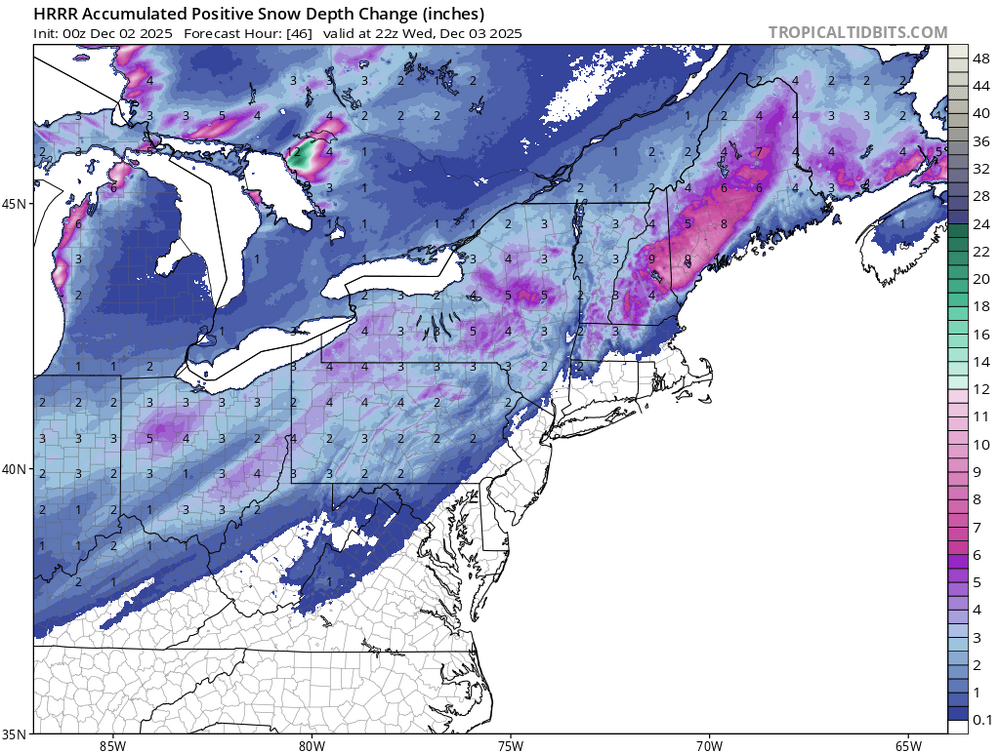
A colder than normal pattern has now moved into place. A prolonged stretch of below normal temperatures will likely continue into or through the second week of December. December 1-10 will be a solidly colder than normal period. The potential exists for the coldest first days of December since at least 2007 (33.4°, 5th coldest December 1-10 since 2000). The five coldest December 1-10 periods since 2000 were: 1. 30.6°, 2002 2. 32.2°, 2003 3. 32.4°, 2000 4. 33.1°, 2005 5. 33.4°, 2007 All 5 of these cases had measurable snowfall in Central Park. A storm will affect the region on tomorrow into Wednesday, bringing 0.50"-1.50" precipitation to the region. Some wet snowflakes are possible in and around New York City early on, but no accumulation is likely. Interior sections have the highest probability of seeing accumulations of snow. Binghamton and portions of northwest New Jersey will likely see 3"-6" of snow with some locally higher amounts. Albany could see 4"-8" of snow. The coldest air mass so far this season could move into the region late in the week. The temperature will likely tumble into the 20s Thursday night into Friday in New York City. Another system could bring some light precipitation to the region during the weekend. The ENSO Region 1+2 anomaly was -0.1°C and the Region 3.4 anomaly was -0.6°C for the week centered around November 26. For the past six weeks, the ENSO Region 1+2 anomaly has averaged -0.18°C and the ENSO Region 3.4 anomaly has averaged -0.67°C. La Niña conditions will likely continue through at least mid-winter. The SOI was -12.82 today. The preliminary Arctic Oscillation (AO) was +0.520 today.
-
26/14 right now. Cold enough!
-
FCPS, VA is not delayed
-
 28 here. It’ll jump 10 in an hour once it turns SE.
 -
First Winter Storm to kickoff 2025-26 Winter season
40/70 Benchmark replied to Baroclinic Zone's topic in New England
Hasn't seemed like it -
12/3 Snow/Sleet/Mix Bag of Everything Discussion/OBS
ChescoWx replied to Mikeymac5306's topic in Philadelphia Region
28.2 degrees DP 17.0 -
Bottomed out at 27.1, now 27.3


.thumb.JPG.418e8a9a2902ae687ec35ff4bc0e038e.JPG)