All Activity
- Past hour
-
Coming down now at a good clip in this band, 1/2 mi vis, SN, 21/19°F.
-
So some notable difference at H5 on the GFS...seem positive so far...vort quite a bit sharper vs 6z at 135. Precip more widespread and more SW to NE oriented. Let's see where this goes
-
The surface seems quite cold
-
Let's keep that CC mix line pinned to 84. I will rip here for a few hours, if so. We've got to be nearing 2" now out there/ Simsbury.
-
We had a round of sleet/snow mix....the sleet is kind of weird because it's not like we're warmed at 800-750 or anything....prob mostly shitty growth as the deeper lift is still west. Temp 28.5F
-
I posted in the wrong thread but we have moderate IP/ZR mix and temps back down to 28F
-

Kick-Off '25-'26 Winter Storm Obs
Damage In Tolland replied to 40/70 Benchmark's topic in New England
Over to zr here -
might be getting some stronger lift overhead but flake size has increased again and intensity has picked up. A good moderate snow falling now. Probably have almost 1/2" down
-
HRRR actually much colder
-
 Wantage NJ...this part 1.2". looks like general 1-1.5" in SC right now and down to near Great Meadows in Warren County where I think its mixed or ice.
 -
I meant we’re back cause of you, GFS is a bit better but not there, completely agree
-
15z HRRR coming in colder out to hr3 .. lets get more people in this!
-
Looks like some modest evaporative cooling as the light snow has grown steadier, touched 30 and back down to 29.3.
-
We need a Goldilocks storm. First was just a tad warmer norther, next is a tad souther fringer and we need one that’s juuuuuist right
-
This from BAMwx’s Michael Clark was released ~30 minutes ago. I’ve yet to watch it. Hopefully it’s reasonable and not swinging for the fences too much: @donsutherland1
-
I'm getting more optimistic about my lower levels looking to my east...main concern may end up being sleet/poor growth.
-

Central PA Fall Discussions and Obs
Itstrainingtime replied to ChescoWx's topic in Upstate New York/Pennsylvania
Ah the joy of living in Lanco: @MUweather Despite early mixing issues, this last burst of snow should push snow/sleet totals into the 2-4” range for most areas north of the Turnpike and west of Rt 15 or South Mtn. However, southern parts of Lancaster and Chester Co’s won’t even get a coating.. along with @millersvilleu . -
All obs this year for me are from Fallston, MD - 11/30 - T 12/2 - A little frz rain to start - trees and car glazed - but 35 and rain for most of event
-
We seem to be narrowing in on a higher likelihood of some light snowfall. Lots of details to be ironed out, with uncertainty about moisture and timing which opens the door for a modern moderate impact event (definitely less likely). Any chance for a higher potential coastal storm can probably be ruled out
-
 So glad the 25 degrees overnight did so much good today.
 -
Some of those mesos yesterday were beyond awful at the sfc. Just complete disaster of a forecast.
-
13f. Light snow. Began around 1000- a little early, nice blob from PQI to Penobscot Bay. Expecting 2-5" had 2"on the ground to start. https://photos.fife.usercontent.google.com/pw/AP1GczNZDQNM1Uhfrzbvs8Xu6EkyJk6e7RI6ySYQDlGZzXV-4QEZDXdZciaO=w1019-h667-s-no?authuser=0
-
Moderate snow now all surfaces covered 27F.
-
also increased qpf 1.20 here
-

Arctic Sea Ice Extent, Area, and Volume
donsutherland1 replied to ORH_wxman's topic in Climate Change
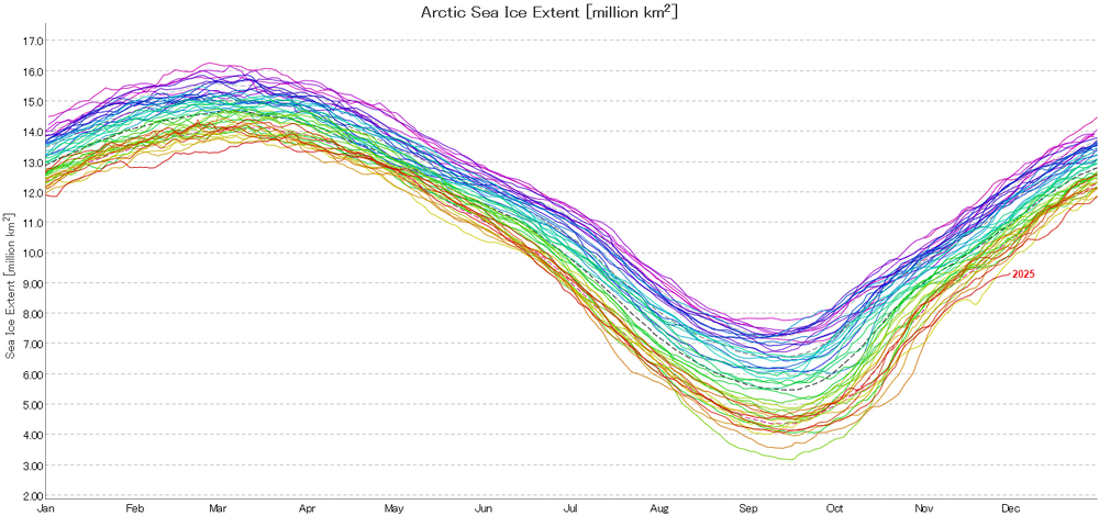
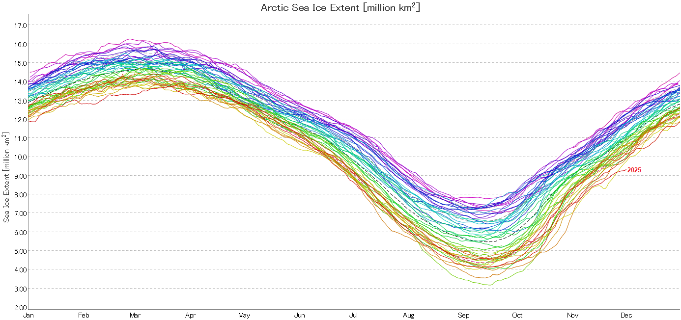
Overall, Arctic sea ice extent is far below the prior record for December 1st. On December 1, Arctic sea ice extent was 9.342 million square kilometers. That was 419,000 square kilometers below the prior record that had been set in 2016. The 2010s average was 10.450 million square kilometers. The 1980s figure was 12.137 million square kilometers. 2024 and 2025 is the first case where two consecutive years saw less than 10 million square kilometers on December 1. Source: JAXA