All Activity
- Past hour
-
Looks like the Euro Op is likely on the NW side of the ensemble envelope, given the Ens mean...
-

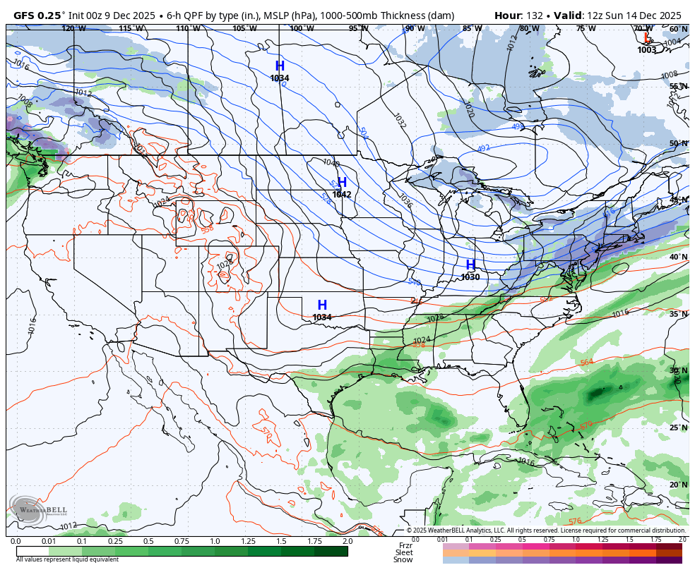
The Monday wintry event potential (12/8/25)
Coach McGuirk replied to GaWx's topic in Southeastern States
I remember the days when I was looking forward to 4/10th of an inch of snow. -
Probably - I still think when the advertised SOI starts to crash towards the end of December that's when the southern jet will begin to produce more wound up systems along with another Strat Warming Event the cold enough air will be available producing more frozen percip...........
-

December 2025 regional war/obs/disco thread
78Blizzard replied to Torch Tiger's topic in New England
Euro further north than GFS and Ukie for Sunday, resulting in mix and rain for EMA. Based on the Euro's 5-6 day performance in the last system, I'll wait on them until 24-36 hrs. -
Bad track for most of us, but at least there's a storm on the Euro...
-

Winter 2025-26 Medium/Long Range Discussion
sbnwx85 replied to michsnowfreak's topic in Lakes/Ohio Valley
Saturday looking interesting. -
Light snow/flurries, I'm looking up in the sky and I don't see a single cloud. Meteorologists, please explain.
-
Until we get straight 3 runs of something similar…
-
Aifs winter storm Dec 23
-
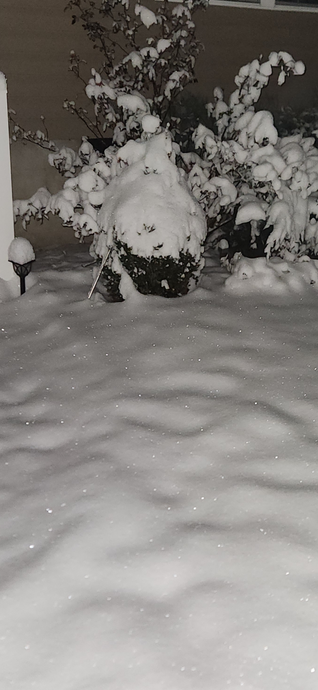
Finished with 4.25... Last flake fell just after midnight , now its perfectly clear and temp of 19 ... Icy look to the snow..

-
Looks pretty good on the AI though
-
Euro strong storm Sunday just has to dig more Now too south Friday too north Sunday
-

2025-2026 ENSO
PhiEaglesfan712 replied to 40/70 Benchmark's topic in Weather Forecasting and Discussion
Now that you put it this way, 2013-14 qualifies as a textbook wall-to-wall cold winter in the Eastern US. Pretty much 5 months straight of cold. Plus, it was a season that showed early cold, with a colder than average August and September.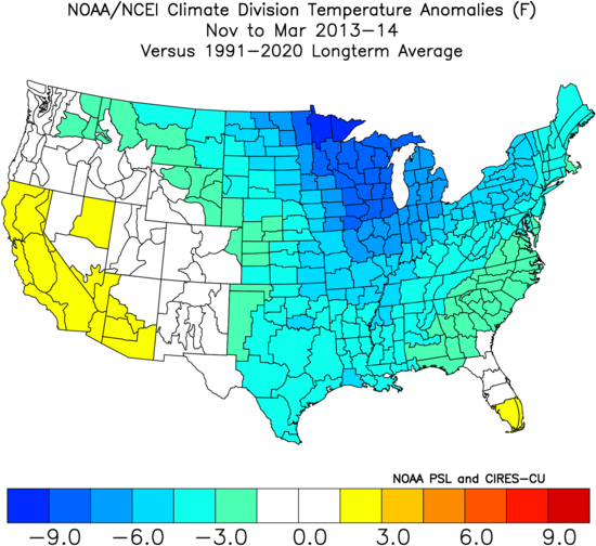
-

Central PA Winter 25/26 Discussion and Obs
MAG5035 replied to MAG5035's topic in Upstate New York/Pennsylvania
Temps have fallen all the way back to 9ºF here so far tonight, with some more room to fall further with a 5ºF dewpoint. KBFD already has another below zero night (-4ºF) currently, which makes two of those within only the first 8 days of December there. Even being generally the coldest official station in PA that’s still pretty impressive. -
Well, given our recent track record, betting against snow isn't the dumbest thing in the world, lol.
-

Central PA Winter 25/26 Discussion and Obs
Blizzard of 93 replied to MAG5035's topic in Upstate New York/Pennsylvania
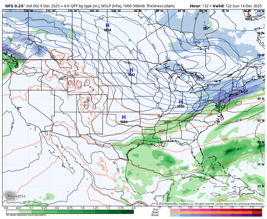
In the shorter term, the 0z GFS still likes the Saturday night chance for an Advisory type of event.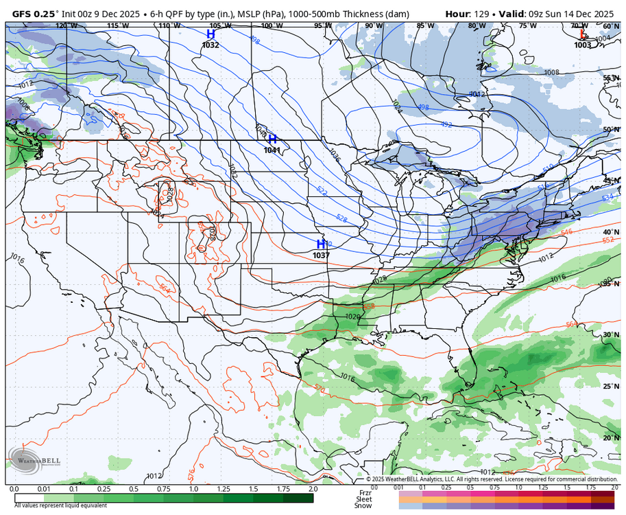
-
And Upton and Mt. Holly are dismissing the storm all together with Sunny Skies......as of this evenings updates - NY NJ PA Weather agrees with this snow map........Who is a Weenie to believe ?
-
Central PA Winter 25/26 Discussion and Obs
Blizzard of 93 replied to MAG5035's topic in Upstate New York/Pennsylvania
0z Canadian shows a chance on the 18th.

-
0z Canadian shows a chance on the 18th.
-
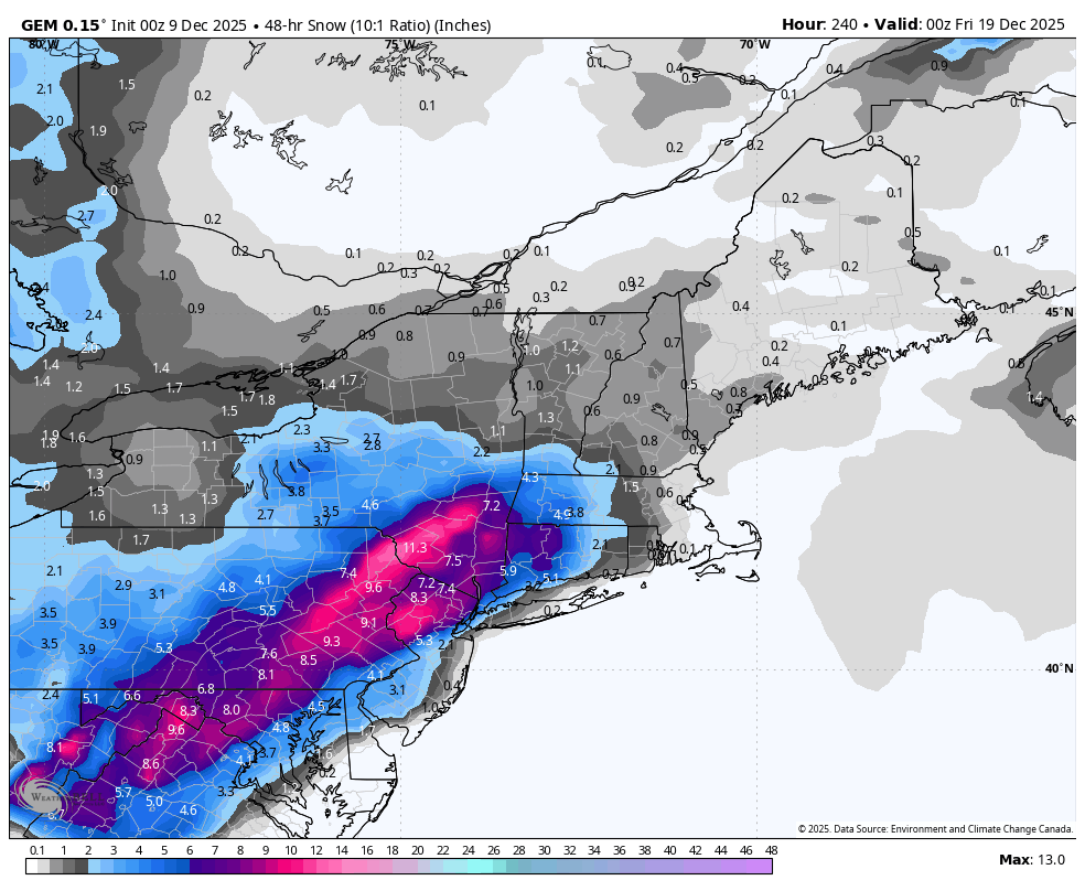
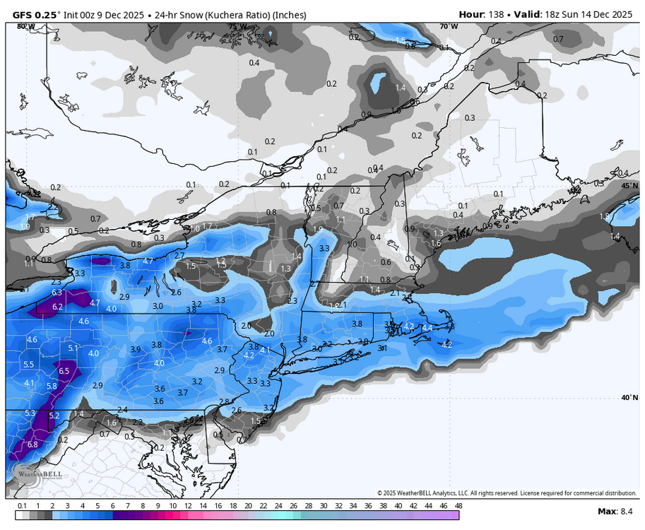
AIFS has been fairly consistent on this threat. Sign me up. Note that there's a few to several inches of snow before this storm N of 84 on this map.
- Today
-
lol - helluva way to lose
-
I measures 2.7in on a table, though on grass I was getting 3.5-4in so I’ll average it out to somewhere around 3 inches of snow. Fridays storm technically had a bit higher total but this storms more compact flakes makes it feel more impressive.
-

E PA/NJ/DE Winter 2025-26 Obs/Discussion
Birds~69 replied to LVblizzard's topic in Philadelphia Region
Midnight, Birds just lost in OT on Hurts 4th int and it's 18F... -
2025-2026 Winter Snowfall Totals
Siberian-Snowcover-Myth replied to George BM's topic in Mid Atlantic
Varina,Va (5 miles SE of RIC) 2.1” 12/5 5.0” 12/8 7.1” Total -

The Monday wintry event potential (12/8/25)
NorthHillsWx replied to GaWx's topic in Southeastern States
Id be willing to say Louisburg has at least an inch judging by my trail cams. Possibly more…