tornadotony
-
Posts
2,734 -
Joined
-
Last visited
About tornadotony

- Birthday 12/06/1989
Recent Profile Visitors


-

Central/Western Medium-Long Range Discussion
tornadotony replied to andyhb's topic in Central/Western States
Yep. As long as the STJ is prominent, say bye-bye to prospects of a significant EML and widespread favorable thermodynamic profile. Gotta hope the first days of these systems are prolific like Wednesday was, or else you know what you're getting afterward. -
Historic Tornado Outbreak April 27, 2011
tornadotony replied to CUmet's topic in Weather Forecasting and Discussion
It's hard to believe until you see it. -
Historic Tornado Outbreak April 27, 2011
tornadotony replied to CUmet's topic in Weather Forecasting and Discussion
I've seen the track thru Anderson Hills, Old Railroad Bed Rd, US 72, Tanner, Hillsboro, Mt. Hope, Oak Grove, Phil Campbell, and Hackleburg. It's incomprehensible that it was all one tornado. Just unfathomable. It goes on and on and on and on forever seemingly. -
Historic Tornado Outbreak April 27, 2011
tornadotony replied to CUmet's topic in Weather Forecasting and Discussion
Was rereading this thread and just came across this...A buddy of mine here at UAH is studying this boundary for his M.S. thesis. The Hackleburg tornado was along or just N of that boundary for most of it's life. It was high-end EF3 to EF5 intensity all the way from just SW of Hackleburg to near dissipation in nrn Madison County, an incredible distance of about 85 miles. The Cullman tornado crossed the boundary near the Cullman/Morgan County line, where it grew to 1 mi wide, high-end EF4, and there was a substantial loss of visibility. Both storms dropped tors within an hour of first echo, 50 min in the case of Hackleburg. He had an oral presentation at SLS last year on it that should be available on the conference site. -
Historic Tornado Outbreak April 27, 2011
tornadotony replied to CUmet's topic in Weather Forecasting and Discussion
It was the multiple, large gouges several feet into the ground that led the Philadelphia tornado to being rated EF5. -
Devastating tornado strikes Joplin, Missouri
tornadotony replied to Hoosier's topic in Weather Forecasting and Discussion
http://www.nist.gov/el/investigations/joplin-072511.cfm -
Devastating tornado strikes Joplin, Missouri
tornadotony replied to Hoosier's topic in Weather Forecasting and Discussion
Just curious regarding the shifting of St. John's...was that the whole building, the big tower, or some other part of it? Anyway you slice it it's impressive...just curious. Also, thanks for sharing your story. I can't imagine what that must have been like to cover that. -
Devastating tornado strikes Joplin, Missouri
tornadotony replied to Hoosier's topic in Weather Forecasting and Discussion
Low-end EF5 is such a joke. That's like saying "small blue whale" or "poorest billionaire." It's stupid. -
Devastating tornado strikes Joplin, Missouri
tornadotony replied to Hoosier's topic in Weather Forecasting and Discussion
My take is that instantaneous is probably being used synonymously with 3-sec gust. It seems bizarre. But to me it makes sense just looking at the death toll. Yeah, it was rain-wrapped, but so was the Moore tornado largely when it was in Moore. Greensburg was at night. Parkersburg was largely rain-wrapped. The Topeka tornado in 1966 wrapped itself in rain as it crossed the city. Rain-wrapping alone cannot possibly explain 142 fatalities. -
Devastating tornado strikes Joplin, Missouri
tornadotony replied to Hoosier's topic in Weather Forecasting and Discussion
I doubt the entire area that SGF has painted as EF5 received EF5 damage. It's impossible to say. I didn't think we'd ever have a tornado on the EF-scale where the MIC at the office in whose CWA it hit would estimate a peak wind of 250 MPH. Think about what kind of damage would have to be done for that estimate and think about the EF-scale. Each ranking of the EF-scale goes by roughly 25-35 MPH gradations. EF0: 65-85 MPH EF1: 86-110 MPH EF2: 111-135 MPH EF3: 136-165 MPH EF4: 166-200 MPH EF5: >200 MPH Essentially, if we still had a "6" rating for a tornado, following that pattern (and even incorporating the fact that the ranges increase as you go up), you'd likely expect this tornado to breach the minimum wind speed for that. Now, how you would describe something as a "6" would be beyond my paygrade. But I'm hoping this puts the level of damage that is being described from SGF into a proper historical perspective. When you legitimately estimate the max winds to be 50 MPH into EF5, you're essentially trying to describe this as being the strongest tornado at least ever surveyed. -
Devastating tornado strikes Joplin, Missouri
tornadotony replied to Hoosier's topic in Weather Forecasting and Discussion
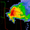
No, it's definitely the EF5 indicator. The colors get a bit garbled on the map because of how they overlay. -
Devastating tornado strikes Joplin, Missouri
tornadotony replied to Hoosier's topic in Weather Forecasting and Discussion
It's great to hear from you! -
Historic Tornado Outbreak April 27, 2011
tornadotony replied to CUmet's topic in Weather Forecasting and Discussion
Errr, no, you cannot possibly have "EF4" damage to trees from a tornado. The EF scale doesn't allow it. -
Historic Tornado Outbreak April 27, 2011
tornadotony replied to CUmet's topic in Weather Forecasting and Discussion
3 confirmed dead in Kemper County MS per TWC Breaking Twitter.