OHweather
-
Posts
4,887 -
Joined
-
Last visited
3 Followers


About OHweather

- Birthday 09/01/1992
Recent Profile Visitors


-
Was sweating the cirrus here in Cleveland but it was thin enough that you could see through them enough to see all the cool stuff. Had the 360 degree sunset effect on the horizons with the cirrus adding some color. Briefly saw a couple of planets. Bats came out, streetlights came on. It was about as dark as it is immediately when the sun sets I would say. Seeing the corona and some solar flares was awesome. The difference in the amount of light between a 99% eclipse and totality was impressive. As soon as even the smallest bit of the sun came out from behind the moon the light noticeably increased. Overall I'd say it exceeded my expectations.
-
4/1-4/2 severe threat (southern portion of subforum)
OHweather replied to largetornado's topic in Lakes/Ohio Valley
A few comments on this event, focused on the Ohio Valley... 1. An enhanced risk (for winds and possibly tornadoes too, pending surveys) was warranted across the Ohio Valley. From a verification stand point I do not think the Moderate Risk panned out anywhere (especially for tornadoes). The northern extent of the threat was significantly less than outlooked. 2. The main reasons this busted were due to repeated rounds of convection that were ongoing both along and north of the warm front and in parts of the warm sector from last night through all of today. This chewed up the EML and limited destabilization farther north and east. You can tell that convection that tried firing along the cold front and a pre-frontal trough in the late afternoon and early evening was struggling due to limited spacing between it and pre-frontal convection that was already ongoing. The storm mode was also messy, probably because junk developed quickly in the warm sector and it was impossible to come back from that. 3. I was concerned about some of the uncertainty and was surprised to see the Day 2 moderate (at least as far north/east as it was). I felt the 12z HRRR and NAM on Monday did depict outbreak scenarios and that the outlook needed to ramp up from the morning outlook on Monday...but there were enough CAMs with less exciting solutions for multiple reasons that the moderate risk was certainly an aggressive forecast. However, I thought something significant still had a decent chance to play out somewhere (likely in the Ohio Valley). With such a large warm sector, deepening low pressure and insane wind fields, it felt like it would be hard to avoid somewhere destabilizing and having a supercell or two take advantage of that locally more favorable environment. It's possible there were a couple of strong tornadoes today and there were probably more than a few weak tornadoes, including with the morning QLCS into WV. However, I would say I definitely expected more to happen even if certain parts of the threat/outlook didn't sit great with me. 4. The Tennessee Valley generally busted too, due to junky convection firing too early in the warm sector down there. This whole event was cursed apparently. 5. Given a fairly legitimate potential for a significant tornado or two somewhere this threat certainly required stronger than normal messaging. However, I feel like the way severe weather outlooks are often presented does not always do a good job of advertising uncertainty or bust potential. It's just "strong to severe storms possible between 3 and 8 PM, here's the outlook showing a slight risk". While I saw a couple of people in OH on Monday mention potential for ongoing clouds/rain earlier in the day to mess with the threat that generally was not mentioned until today when it was in fact raining. Instead, the messaging was focused on what is pretty much an unprecedented severe weather outlook, a Day 2 moderate risk driven by tornadoes. That was messaged as a very rare outlook for Ohio (which is not incorrect) and took on a life of its own. The event couldn't bust without meteorologists looking bad, so of course it busted for most of OH. Overall, severe weather risks that have a ceiling of a regional tornado outbreak but legitimate bust potential are a challenge to message and there's room to get better at it. -
4/1-4/2 severe threat (southern portion of subforum)
OHweather replied to largetornado's topic in Lakes/Ohio Valley
The stuff currently developing from central IN into KY (and anything that fires immediately ahead of it) will be “the show”. We’ll see what the show ends up being. Airmass recovery attempting to occur ahead of that activity but it’s a short window to do it. The low is deepening so wind fields will be extremely robust. We’ll find out quite a bit about if much will happen in the next few hours. -
4/1-4/2 severe threat (southern portion of subforum)
OHweather replied to largetornado's topic in Lakes/Ohio Valley
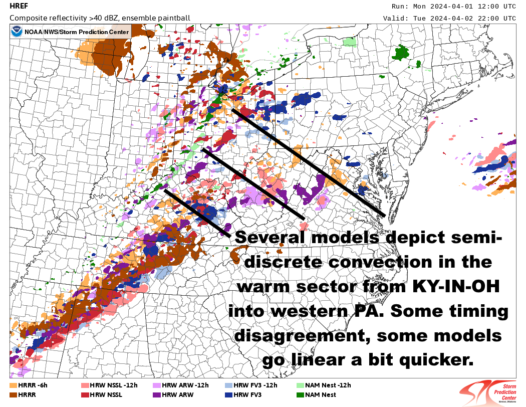
0z HREF probability for STP >3 and member updraft helicity (supercell) tracks. Mod-high probabilities for STP >3 from central OH-IN through parts of KY & TN surrounded by lower probabilities, with sct'd individual member supercell tracks. The setup has a high ceiling, but: Neighborhood probabilities for supercell tracks are moderately high in the Ohio Valley (best environment), high in the Tennessee Valley (slightly lower STP >3 probs), and low-moderate north into IN/OH/W PA (lower confidence in STP >3 farther north). There is uncertainty: For instance, the 0z HRRR has extensive elevated convection in the Ohio Valley that continues through midday, with warm sector convection becoming widespread by 18z. This would be some sort of (potentially more middling, though with conditional risk for strong tornadoes still) OH/TN Valley tornado threat but with more limited northward extent into IN/OH. On the other hand the NAM clears the morning Ohio Valley convection slightly quicker and also delays warm sector initiation longer into the afternoon. This would lead to a likely more significant tornado threat in the Ohio Valley that extends into much more of Ohio. The NSSL WRF is a bit in between. It clears the Ohio Valley morning convection a bit quicker but also has a fairly busy warm sector by mid-afternoon. Verbatim it still would be a somewhat messy Ohio/Tennessee Valley evolution but there would be a tornado risk, especially in the Ohio Valley where there could still be a conditional significant tornado risk with this sort of evolution. In terms of northern extent, there'd be at least some threat for most of Ohio along and south of the warm front. And finally, the ARW with similarities to the NSSL, clearing the morning convection fairly early and developing warm sector convection a bit quickly (tho not as fast as the HRRR), with a middle ground solution in terms of overall tornado risk and northward extent into OH: Some subtle adjustments can probably already be justified for the initial day 1 outlook at 2 AM eastern...however, I doubt there will be anything wholesale until later in the morning when it's much more obvious how the ongoing convection is behaving. 3z HRRR would probably play out somewhat close to the 0z NSSL WRF if it ran out further....thumb.gif.cc810b8395d8b7edffa175d624be5834.gif)
.thumb.gif.353da14bbc670485f4234660324d3767.gif)
.thumb.gif.c2763d2a53abede04b292d7fcae07f8a.gif)

-
4/1-4/2 severe threat (southern portion of subforum)
OHweather replied to largetornado's topic in Lakes/Ohio Valley
I'd lean more towards the convection eroding the EML than the other way around. -
4/1-4/2 severe threat (southern portion of subforum)
OHweather replied to largetornado's topic in Lakes/Ohio Valley
Yes, my take on the 0z HRRR was that it being more expansive morning MCS in the Ohio Valley, with elevated convection continuing to fire overtop its cold pool through the early afternoon and convection firing in the warm sector and becoming widespread by mid-afternoon, were why it didn't really destabilize north of southern OH. We may have a better lean on how that will play out within the next few hours. Yes, I assume there was a ton of internal discussion about the outlook. I was off today so can not confirm or deny. It is a tough spot, and the initial day 2 pulling things farther south really made things worse. I do think that the setup can support one or two long-tracked, violent tornadoes, so based on that I can not fault the day 2 moderate risk. If you expect long tracked, violent tornadoes that's more than an enhanced risk. I could perhaps quibble with it being placed so far northeast, but I do think there is a conditional threat in at least the entire moderate and enhanced risk areas so I can't totally fault it either. Some of the messaging I've seen regarding this threat is some of the strongest I've ever seen around here...there is something to be said about being sure before breaking out the strongest possible messaging. I'm both worried about the higher end of the potential and what that could look like (even if it's just one or two really nasty tornadoes) but am very uncertain on where or if we'll see that pan out. -
4/1-4/2 severe threat (southern portion of subforum)
OHweather replied to largetornado's topic in Lakes/Ohio Valley
Considerable uncertainty, largely driven by ongoing/earlier-day convection, is definitely a familiar feeling for the Ohio Valley. There certainly is higher-end tornado potential if a portion of the warm sector is relatively clear and can recover through at least the mid-afternoon, and I feel like that's more likely than not to occur somewhere in the vicinity of central/southern IN, western/southern OH, and perhaps adjacent northern KY. Where exactly that occurs and how large of an area it is are certainly in question. From a messaging perspective this is kind of brutal...I'd consider northern and even central (especially east-central) OH to be on the fringe. If ongoing convection and clouds clear quickly enough there's still a viable scenario where those areas recover enough to have a threat, and given the amount of shear in place that needs to be messaged. However, it's also possible that little happens on that northeastern fringe. We've already gone all-in with a tornado-driven moderate risk, so while I'm personally hoping for (and sort of leaning towards) nothing too noteworthy happening in the Cleveland metro and my immediate vicinity just south of Cleveland, a total whiff in the northern/eastern half of Ohio would be a strike against public trust in the severe wx forecasts. -
4/1-4/2 severe threat (southern portion of subforum)
OHweather replied to largetornado's topic in Lakes/Ohio Valley
Some random thoughts based off of the 0z NAM and HRRR...how quickly morning convection exits and allows the warm front to start lifting, along with if convection starts getting pretty widespread in the Ohio Valley by mid-afternoon, which would further limit northward/northeastward moisture return and recovery, are both major sources of uncertainty regarding the northeast extent of the tornado threat. Also, models are still trending slower/west with the low and jet streak. I think the northern/northeastern portion of the higher tornado probs should be trimmed, perhaps notably, and the overall highest tornado probs shifted a bit farther SW. We'll see what the rest of the 0z models show and what the initial day 1 outlook comes up with. -
4/1-4/2 severe threat (southern portion of subforum)
OHweather replied to largetornado's topic in Lakes/Ohio Valley
Broyles has gotten better over the years and usually the SPC is pretty good about not whipping around the outlooks too much, but I don’t think anyone was very happy with the initial Day 2 outlook this morning to say the least -
4/1-4/2 severe threat (southern portion of subforum)
OHweather replied to largetornado's topic in Lakes/Ohio Valley
WOW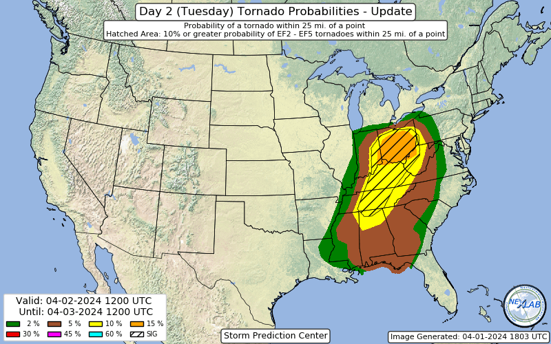
-
4/1-4/2 severe threat (southern portion of subforum)
OHweather replied to largetornado's topic in Lakes/Ohio Valley
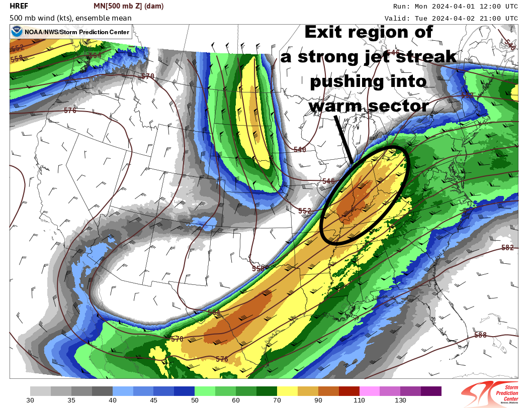
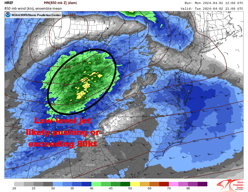
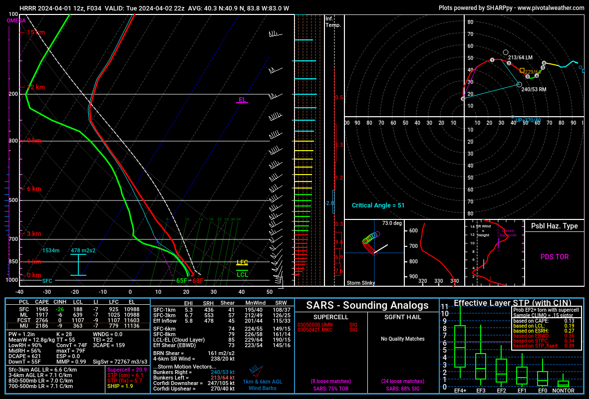
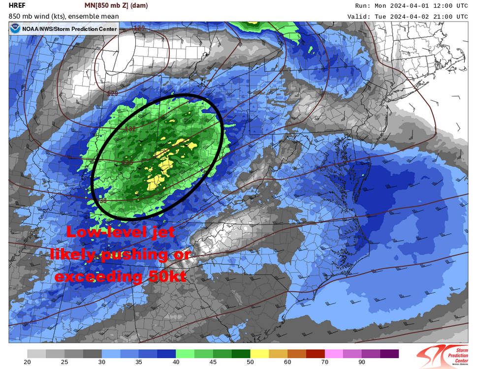
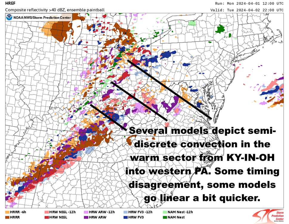
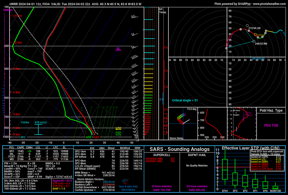
A large and moist warm sector with well-established return flow beneath a remnant EML plume, along with the exit region of a ~100kt 500mb jet streak nosing into the warm sector during the afternoon and evening, is a very concerning synoptic signal in IN/OH/possibly northern KY and adjacent areas. In all likelihood the 850mb flow will be pushing or exceeding 50 knots as well. There is some uncertainty regarding the degree of destabilization farther north, how backed the surface flow is, and the exact convective evolution per CAMs. My gut feeling is that if AM clouds/rain get out of the way that the strong kinematics and rich warm sector could allow for rapid recovery (as we saw on March 14th), and the strengthening nature of the surface low should back the low-level flow more (along the lines of the NAM/HRRR/RRFS, as opposed to the ARW and to some extent NSSL which are a bit more paltry with the low-level backing and resultant SRH). Shear vectors oriented about 45 degrees to the cold front should lead to a period in which discrete or semi-discrete right-moving supercells are favored before growing upscale. This area-averaged HRRR sounding from a chunk of NW/central OH ahead of the supercells it has at 22z tells us there's very high-end potential if everything comes together correctly:.thumb.png.e6033473972a11cfb96beec61b03304f.png)

-
2024 Short/Medium Range Severe Weather Discussion
OHweather replied to Chicago Storm's topic in Lakes/Ohio Valley
The long-tracked supercell that started near Findlay and later produced the EF-2 in Crawford and Richland Counties was actually not too bad to track all things considered. Regarding the radar coverage there, you are entirely correct. Several years ago they added a supplemental lower radar tilt on a number of 88D radars (in most cases, 0.2 or 0.3 degrees) to attempt to help give better low-level radar coverage to more areas...the CLE radar was one of those but due to beam blockage our supplemental tilt is 0.4 degrees. We turned it on as that cell developed west of Findlay and it lowered our lowest beam height from slightly over 10k feet to slightly over 9k feet Regardless of the poor radar coverage, it helped that when the cell was that far away in poor radar coverage that it was light out and we had several people looking at it. The initial Tornado Warning felt slightly flimsy...it was a marginally strong-enough couplet at 9-10k feet, and given it was a discrete supercell in an environment favorable for tornadoes (the effective sig tor parameter was 2-3 at the time) the course of least regret was to go with a TOR. Immediately after that was issued we had a trained spotter call from just west of Findlay with a persistent rotating wall cloud (definitely enough to warn on in an environment favorable for tornadoes if radar is sampling a mesocyclone with the storm). That spotter called back off and on, we also had a few other public and spotter calls as it moved across Hancock and into southwestern Seneca, were streaming county dispatches on broadcastify (law enforcement was reporting funnels and possible tornadoes), and had HAM radio operators in the office who relayed a couple of reports from other HAM radio operators out in that area. Despite the poor low-level radar coverage, we were fairly confident it was trying hard (but probably not putting down anything too strong or persistent) from just east of Findlay into southwestern Seneca County. We finally confirmed an EF-Unknown tornado from far eastern Hancock into southwest Seneca. It's possible there were brief touchdowns before and after this, but this was the area where we had multiple, firm eyewitness accounts (with roads/directions clearly listed and consistent among reports) along with multiple pictures and a video of a tornado in a field. We did not hear anything concrete for a chunk of time is it moved across southeastern Seneca into extreme northeastern Crawford County despite a relatively decent couplet through there (it's very sparse in there and it was starting to get pretty dark...we also found no damage in that area so it likely wasn't quite producing or was just producing very weak/brief stuff in fields). By the time it produced the EF-2 in northeast Crawford/northwest Richland the radar coverage was better (we were hitting it at <5k feet by then) and it did briefly have an intense couplet and definite TDS, which allowed us to go with "radar confirmed" wording in the warning despite still not getting any concrete reports. We were on the fence regarding going with the "particularly dangerous situation" or "large and extremely dangerous tornado wording" in the warning (which is intended for high-confidence, potentially strong ongoing tornadoes but is a level below a Tornado Emergency, which is reserved for high-confidence and likely violent ongoing tornadoes) and finally got a call from an EM, who relayed a report from a fire department of a large (they said "half mile wide" though it was more like 250 yards) tornado currently on the ground, at which point we went with the higher wording. From there the tornado quickly lifted as the storm appeared to cycle and it never produced after that. NOW, as for the cell behind that, responsible for the (unwarned) EF-1 tornado southwest of Jenera in Orange and Van Buren townships...that was just annoying and is very symbolic of our challenges along I-75 (especially in Wood and Hancock...the Detroit radars can help with Lucas). The storm did not look impressive at all on radar, did not produce any upstream reports of anything close to tornadic in Allen County, and then dropped an EF-1 in Hancock. We heard about it pretty quickly and issued a warning when we got multiple reports of a tornado on the ground but had already missed it. It's annoyingly common that marginal looking storms on radar west of I-75 are unwarned and don't generate reports and then all of a sudden produce reports when they hit more population along I-75. I'm glad to hear that your family made it through but am sorry to hear about the house you grew up in. I was a little curious to see if that may get an EF-4 rating. It seemed like the only damage truly in question was the Taco Bell...the expected wind speed for that damage indicator (complete destruction of a small retail building) is 167 MPH (EF-4) but they went 165 MPH (EF-3). I had seen one or two pictures of what looked like actual bolts ripped from the foundation (which would be proper construction) but also saw several more pictures where it appeared to just be straight nails holding the building to the foundation (which will give way much quicker and don't support an EF-4 rating). I'm curious if they found legitimate construction issues with the Taco Bell (i.e. anchored with nails and not bolts) and kept it an EF-3 for that reason (perfectly valid) or if they thought the Taco Bell was well-constructed but kept it an EF-3 due to a lack of other EF-4 damage indicators (which I have more mixed feelings on, especially in a multi-vortex tornado where the strongest winds will occur in very small suction vortices). Right or wrong, it's seemingly very difficult to get a higher tornado rating if it's just one damage indicator that supports it unless the one DI is very solid, and there were other structures around the Taco Bell that weren't really in consideration for the higher rating. I try not to get caught up in the rating debate too much because ultimately it's the people who lost loved ones and/or had their lives turned upside-down that really matter, but there's uncertainty in a lot of stronger tornado ratings...I feel like the burden on proof for a higher rating is placed on the tornado when they decide the final rating when there’s uncertainty and could go either way (if that makes sense). -
2024 Short/Medium Range Severe Weather Discussion
OHweather replied to Chicago Storm's topic in Lakes/Ohio Valley
There were several photos and eyewitness reports of a tornado east of Findlay, north of Vanlue and into Seneca County near Alvada and southwest of New Riegel. Finding damage has been difficult in that area. Stay tuned for some sort of final assessment of that area. But yes, the confirmed EF-1 in southwest Hancock County was with the next cell that came in behind the tornado warned cell. -
2024 Short/Medium Range Severe Weather Discussion
OHweather replied to Chicago Storm's topic in Lakes/Ohio Valley
This case is a good example of why conditional intensity outlooks for severe wx, which are in the works, will be beneficial. SPC didn't seem sure if there'd be recovery behind the morning-early afternoon round of convection, so the outlook probabilities (which are unconditional) could theoretically only be so high...however, if the airmass recovery happened the shear profiles and expected storm mode were quite favorable for tornadoes, so the conditional potential for stronger tornadoes was higher than the unconditional outlook probabilities may have conveyed. Unfortunately, there isn't a great way to message that with the current paradigm outside of hoping someone at a WFO is paying enough attention and is confident enough to ring that bell when they are looking at a pretty run of the mill 2-5% tornado outlook. Is there an argument that with an EML, very strong wind fields, and decent CAM agreement that we would recover that perhaps the SPC should've just bought into the recovery more and gone with higher probs? Yes I'd say that argument is there, as my experience is that you usually don't struggle to recover (and that the CAMs usually do quite well) when there's stronger forcing/shear and an EML nearby. I'd give a pass before the 1630z outlook though because the recovery behind earlier convection is always difficult to gauge and it was only mid-March, and even at 1630z perhaps it was too early to truly have confidence in sufficient airmass recovery/destabilization. By 20z I'd say given the CAM agreement and observational trends that higher probs were probably pretty easily justified. By then you're almost into the watch stage though so the gain isn't a ton even if they did go with higher probs in that outlook. A handful of significant tornadoes with fatalities occurring in a 2-5% tornado outlook is not ideal, though I agree that there have been worse forecast bursts before. I did not wake up Thursday morning thinking I'd issue a PDS Tornado Warning that day. By mid-late afternoon we were locally getting quite concerned about the potential severity of any storms that made it into our southwestern CWA that evening and ended up with an EF-2 (along with an EF-1 and what will probably go in as an EF-U) out of it. Eastern IN into western and central OH, largely out of the CLE CWA, really took it on the chin compared to us though. -
Have been out at Punderson the last hour or so. Measured 6-7” here with occasionally moderate snow still ongoing. Roads actually aren’t bad out here…gotta love fluffy daytime snow in March. Had about 2” at home when I left.


.gif.ba033bc476ed1dcf7f29e860bd6daa0c.gif)
.gif.32ccbf095e9d9775f131a83bde4a876d.gif)
.gif.9e11d0dfddb0cdc4e6e499b5bcfe6834.gif)

.png.653ab47de198354d1147af97606594f9.png)