

yoda
-
Posts
59,374 -
Joined
About yoda

- Birthday 09/30/1986
Recent Profile Visitors
13,473 profile views


-
Big Flyers fan unfortunately tomorrow
-
The Germantown storms were too far SW?
-
Welp, looks like I got a rock today
- 228 replies
-
- 2
-

-

-
- severe
- thunderstorms
- (and 5 more)
-
I think we easily verified the watch box today
- 228 replies
-
- 3
-
-
- severe
- thunderstorms
- (and 5 more)
-
Rotation also on that storm
-
Preliminary Local Storm Report National Weather Service Baltimore MD/Washington DC 322 PM EDT Mon Apr 15 2024 ..TIME... ...EVENT... ...CITY LOCATION... ...LAT.LON... ..DATE... ....MAG.... ..COUNTY LOCATION..ST.. ...SOURCE.... ..REMARKS.. 0315 PM Hail 1 E Falls Church 38.89N 77.16W 04/15/2024 M1.25 inch Arlington VA NWS Employee NWS Employee reported half dollar sized hail. && Event Number LWX2403045
-
Preliminary Local Storm Report National Weather Service Baltimore MD/Washington DC 326 PM EDT Mon Apr 15 2024 ..TIME... ...EVENT... ...CITY LOCATION... ...LAT.LON... ..DATE... ....MAG.... ..COUNTY LOCATION..ST.. ...SOURCE.... ..REMARKS.. 0321 PM Hail Falls Church 38.89N 77.18W 04/15/2024 M1.00 inch City of Falls Chur VA Trained Spotter A trained spotter reported 1 inch hail near the 400 block of W Broad St in Falls Church. && Event Number LWX2403047 Preliminary Local Storm Report National Weather Service Baltimore MD/Washington DC 325 PM EDT Mon Apr 15 2024 ..TIME... ...EVENT... ...CITY LOCATION... ...LAT.LON... ..DATE... ....MAG.... ..COUNTY LOCATION..ST.. ...SOURCE.... ..REMARKS.. 0318 PM Hail Vienna 38.90N 77.25W 04/15/2024 M1.00 inch Fairfax VA Amateur Radio && Event Number LWX2403046
- 228 replies
-
- 1
-
-
- severe
- thunderstorms
- (and 5 more)
-
@MN Transplant guess this was just north of you? Emergency management and NWS employees report half dollar size hail in Falls Church per LSR
-
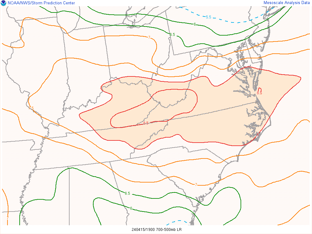
Don't see this either everyday in our region - 3pm mid-level lapse rates
- 228 replies
-
- 1
-
-
- severe
- thunderstorms
- (and 5 more)
-
Warrenton cell just went severe
-
Looks like the Fairfax cell is dragging an outflow boundary behind it/to its west on Radarscope?
- 228 replies
-
- 1
-
-
- severe
- thunderstorms
- (and 5 more)
-
Area Forecast Discussion National Weather Service Baltimore MD/Washington DC 229 PM EDT Mon Apr 15 2024 .SYNOPSIS... A cold front will drop southward through the area tonight, before returning northward as a warm front on Wednesday. A strong cold front will move through this weekend, with high pressure building in early next week. && .NEAR TERM /THROUGH TONIGHT/... Severe Thunderstorrm Watch #109 is valid until 10 PM since it covers most of VA to the NC border, although storms are likely to exit our forecast around 7 PM. Very steep mid-level lapse rates of around 8C/km due to 500 mb temps of around -20C were observed on earlier upper air data and more recent MetOp-C NUCAPS data. This will contribute to a very favorable environment for large hail perhaps approaching significant hail up to 2 inches in diameter. Storms will be fast movers moving around 35 knots and given large dewpoint depressions and strond mid-level flow may be also capable of producing strong to damaging winds. Storms should exit our CWA by 8 PM, likely a little sooner than that. Rapidly clearing skies are expected later this evening behind exiting cold front. High pressure builds over the area overnight into Tue morning with quiet conditions overnight through Tue morning.
- 228 replies
-
- 1
-
-
- severe
- thunderstorms
- (and 5 more)
-
Coming for @MN Transplant BULLETIN - IMMEDIATE BROADCAST REQUESTED Severe Thunderstorm Warning National Weather Service Baltimore MD/Washington DC 259 PM EDT Mon Apr 15 2024 The National Weather Service in Sterling Virginia has issued a * Severe Thunderstorm Warning for... The southwestern District of Columbia... Arlington County in northern Virginia... The City of Falls Church in northern Virginia... Northeastern Fairfax County in northern Virginia... The City of Alexandria in northern Virginia... * Until 345 PM EDT. * At 258 PM EDT, a severe thunderstorm was located over Reston, moving east at 30 mph. HAZARD...Quarter size hail. SOURCE...Trained weather spotters. IMPACT...Some hail damage to agriculture is expected. * Locations impacted include... Arlington, Alexandria, Reston, Annandale, Vienna, Falls Church, Pimmit Hills, Reagan National Airport, Mclean, Rosslyn, Crystal City, Howard University, Oakton, Lincolnia, Tysons Corner, Wolf Trap, Merrifield, Lake Barcroft, American University, and I66 and I495 Interchange. PRECAUTIONARY/PREPAREDNESS ACTIONS... For your protection move to an interior room on the lowest floor of a building.
-
Severe Weather Statement National Weather Service Baltimore MD/Washington DC 242 PM EDT Mon Apr 15 2024 VAC059-107-151900- /O.CON.KLWX.SV.W.0015.000000T0000Z-240415T1900Z/ Loudoun VA-Fairfax VA- 242 PM EDT Mon Apr 15 2024 ...A SEVERE THUNDERSTORM WARNING REMAINS IN EFFECT UNTIL 300 PM EDT FOR SOUTHEASTERN LOUDOUN AND NORTHWESTERN FAIRFAX COUNTIES... At 242 PM EDT, a severe thunderstorm was located over Brambleton, moving east at 35 mph. HAZARD...Golf ball size hail reprted by a trained spotter in Hanson Park. SOURCE...Trained weather spotters. IMPACT...Hail is large enough to dent and damage vehicles. Some damage to roofs, siding, and windows is possible. Locations impacted include... Reston, Herndon, Fairfax, Broadlands, Brambleton, Dulles International Airport, Ashburn, Oakton, Sterling, Wolf Trap, Great Falls, and Arcola. PRECAUTIONARY/PREPAREDNESS ACTIONS... For your protection move to an interior room on the lowest floor of a building. && LAT...LON 3898 7726 3886 7731 3887 7733 3897 7758 3902 7756 TIME...MOT...LOC 1842Z 287DEG 29KT 3897 7750 THUNDERSTORM DAMAGE THREAT...CONSIDERABLE HAIL THREAT...RADAR INDICATED MAX HAIL SIZE...1.75 IN WIND THREAT...RADAR INDICATED MAX WIND GUST...<50 MPH
-
Trained spotters reported goofball size hail in Hanson Park - that's the Fairfax/Loudoun warned cell
