MAG5035
-
Posts
5,718 -
Joined
-
Last visited
About MAG5035

- Birthday 03/14/1986
Recent Profile Visitors
5,945 profile views


-
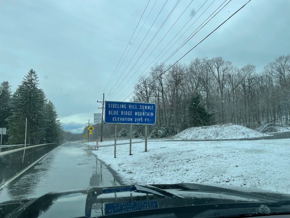
In my travels today this was Sideling Hill summit on route 30 in Fulton County. A little bit after 3 this afternoon.
-
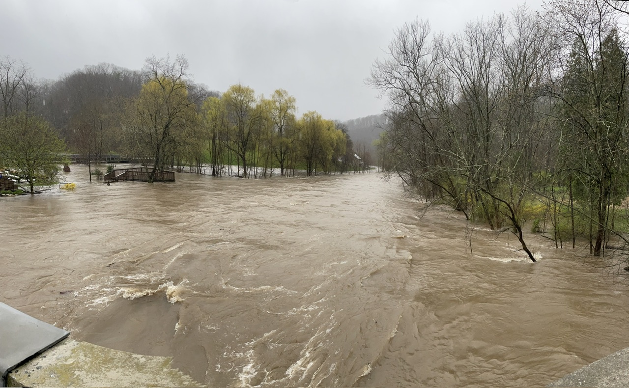
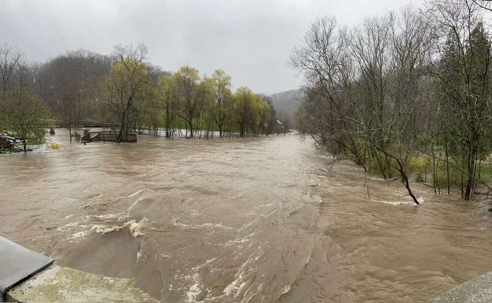
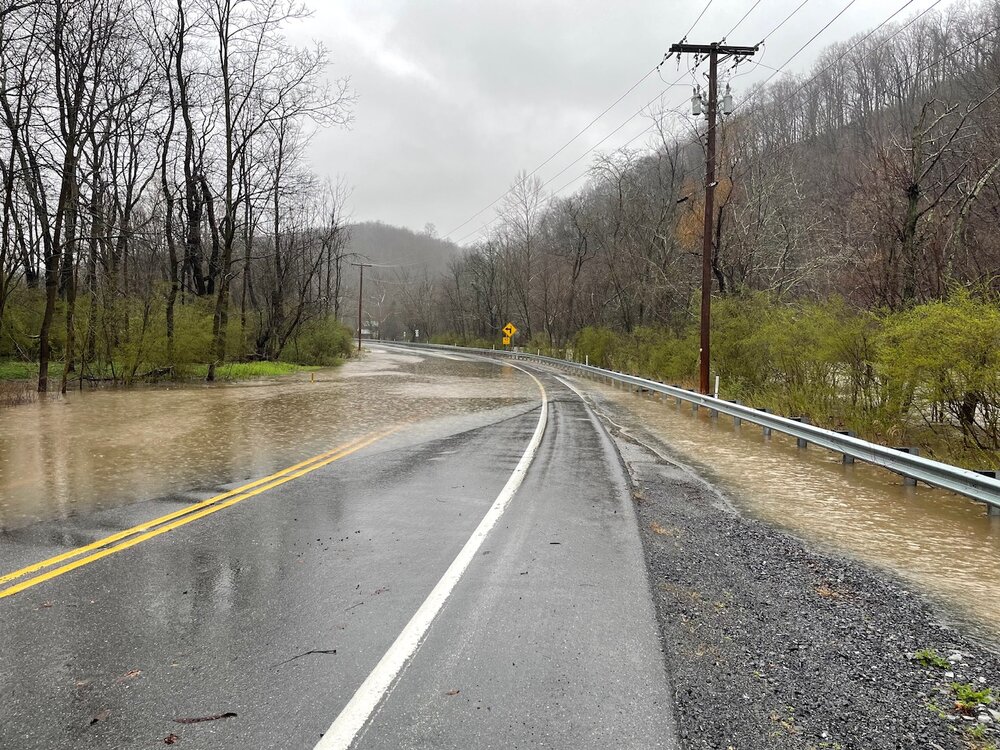
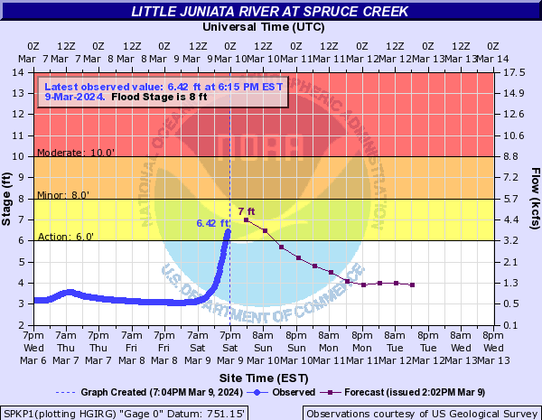
Still some lingering rain falling. Temps are also falling, now back to 39ºF. Event total rainfall here is now 5.08” since Sunday Night. There has been plenty of flooding issues today and closed roads. Frankstown Branch of the Juniata now cresting just inside major flood stage around 15.5 feet at the Williamsburg gauge. Little Juniata is receding, having crested mid-late afternoon in moderate flood stage at about 10.7 feet. Here was some pics I got just a little bit downstream from the Little Juniata @ Spruce Creek gauge around the time of it’s crest.
-
2.3” was the daily total at midnight. Already 0.67” since midnight. Flooding issues of the small stream and poor drainage variety are occurring again. Another significant wave of rain on the doorstep.
-
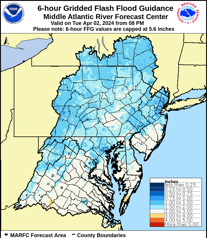
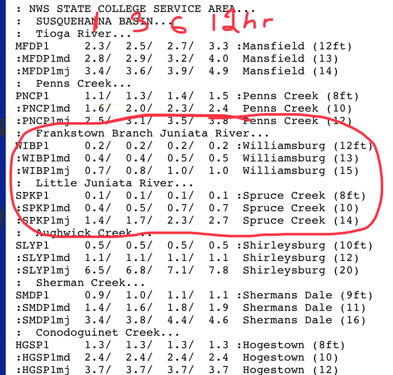
Approaching 2.0” for the day (1.98”) and 2.71” for the event. I’m legitimately concerned for flooding in the local tributaries around here given the new headwater guidance this evening and the amount of rain forecast to fall yet thru tomorrow. There were already some issues today and the Little Juniata had already edged above flood stage early this evening for a bit. The Frankstown Branch is highly likely to get to major, and the Little Juniata has a shot at major too, but certainly a moderate range crest looks increasingly likely. Both branches with that kind of response would likely mean issues on the main Juniata thru Huntingdon and Lewistown. Here’s the updated overall FFG for 6hrs in the MARFC coverage area.

-
Raining heavily currently. Total for just today is already up to 1.7”, with 0.71” falling Sun Night into Mon morning.. bringing the event total to 2.41” already. I anticipate some flooding issues around here, especially with more periods of rain to come through tomorrow.
-
AccuWeather’s got you haha
-
About an inch of snow fell here overnight, the biggest such snowfall since all the way back on 2/17.
-
32ºF and flakes flying, no accums currently
-
58ºF for high on this last decently warm day before we get cold for a bit, in response to finally having a period of significantly -EPO. After this week the grass is definitely awake, even saw a dandelion in the yard.
-
Just missed 70 the last couple days but it sure made it today. As high as 74ºF here so far this afternoon. Checked KAOO to see if it was a record day at 73ºF there and it apparently was not. The 80ºF daily record high in 1990 would appear to be safe.
-
Last night was blustery but not overly windy down here, but it’s been a different story this morning though since just before daybreak. My station registered a high gust of 59 mph around 715am and there’s been plenty of 40+ gusts.
-
More robust daytime heating at the surface over there probably resulted in higher wind gusts mixing down this afternoon. High res guidance increases the winds aloft overnight into the early part of the day tomorrow. So similar gusts are likely to continue. My high gust at home today is 32.4mph and most of the ASOS and RWIS around here (KAOO, KJST, etc have had max gusts in the 45mph range so far.
-
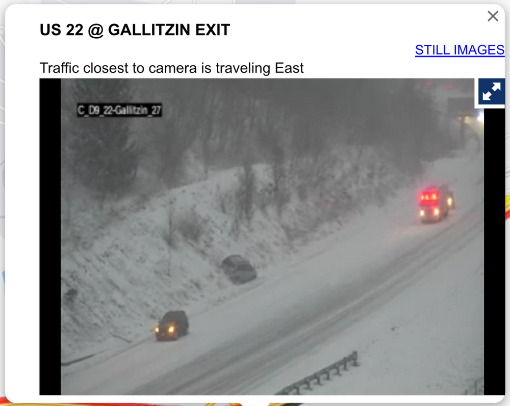
Laurel’s are looking pretty rough, specifically on the US 22 corridor right now in Cambria at the top of the mountain above Altoona. Pretty wintry down here too, with a coating of snow on the ground and occasional heavier snow squalls blowing around. But roads are uncaved at the moment. Temp is 30ºF
-
I’d imagine the gauge station down the road from there near Spruce Creek will get above flood stage and they’ll need an actual warning for that branch which is the Little Juniata. Moderate flood stage at 10ft is roughly the benchmark for the road caving to the river along that stretch of 453. r Frankstown Branch follows 22 to Hollidaysburg, that one might be close to needing a warning too. This has probably been the highest QPF event of the winter around here outside of the 1/9 warning snow to 1”+ of rain. Got 1.65” in the gauge with one more wave of rain to get through this eve.
-
Certainly an advisory looks probable there, and possibly some of the other counties in western PA along I-80 outside of the snow belt immediately off of Lake Erie. Temps at elevation in the Laurels look to be plenty cold (falling into the mid 20s Sunday), so snow will likely pile up once it gets going. Once east of the Laurels likely nothing major accum wise, however there could be some potent squalls that traverse the central counties on Sunday. With regard to WSW potential, duration is likely a factor in probably not seeing amounts like that in the Laurels outside of the very highest elevations. The back lash event itself looks potent though, with -10 to -12ºC 850mb air coming across the well above average and unfrozen lakes. Couple that with March solar and daytime instability and I think we’ll see some long reaching squalls and potential snow squall warnings especially in the central part of the state as mentioned. Surface temps in the Sus Valley will be warmer but anything stronger that makes it over there will likely crash temps and become snow.