Normandy
-
Posts
748 -
Joined
-
Last visited
About Normandy

Recent Profile Visitors
2,332 profile views


-
Busts are required for the joys of successful setups to occur. That’s the game. Let’s see how today pans out
-
Geez this must be a big setup if y’all are making a thread six days out. Tuning in.
-
4/1-4/2 severe threat (southern portion of subforum)
Normandy replied to largetornado's topic in Lakes/Ohio Valley
Will be tuning in and listening. Thanks In advance to all those who will posts the reports / radar images / updates. Best of luck to chasers and those affected -
Otis is easily one of the wildest hurricanes I’ve seen. The damage it did in the small amount of time was something else. Hopefully the city is on their way to a fast recovery
-
2024 Atlantic Hurricane Season
Normandy replied to Stormchaserchuck1's topic in Tropical Headquarters
While US interests are obviously on alert, the big takeaway I have is that the Caribbean is in for a brutal, brutal season if these models are correct. And I tend to believe them because they were excellent last year at this time based on how 2023 played out -
Looks like some kind of mesolow developing NW of Chicago near green oaks
-
@Derecho! hit the nail on the head with his astute observation. To unpack the hood on this even further: I’d like to explain in high rises what the interior spaces are actually designed to do in the event that a natural disaster like a fire or category five hurricane. The building is suppose to ensure the safe egress of occupants out of said structure, and if that is not possible then occupants of the building need an area of refuge where they can shelter in place until they can be rescued. this sentence means in laymen’s terms: your condo is not designed to protect you in a category five hurricane. However the high rise structure that your condo does sit in is designed to protect you if you go inside the stair well. Developers and some architects won’t explicitly state this; the curtain wall systems of high rise buildings are designed to withstand 115 mph usually, but are assumed to fail in the event of winds greater than 155 mph. This is why the code requires high rise structures to have interior fortress like stairwells and areas of refuge so people can hide. One thing I’d love to see incorporated into the building code for residential use in high-rise structures: interior safe rooms (maybe 6’x6’) within each dwelling unit that are of forced to comply with the same code requirements as stairways. Same concept as saferoom or basement in single family homes. This could be a minimal cost approach that could help make these tall buildings a little safer than they already are. All 700 tenants of a high rise structure shouldn’t have to hide in the stairwells during a cat 5
-
High rise structures in general are governed by the IBC section 202, which is an international building code that is adopted by local enforcing agencies. The california building code (CBC 403.1) is derived from this code, and one can most reasonably believe Acapulco and other modern cities in the western pacific coasts in North America adopt this code. In other words….there is no high-rise in a modern city that is not well built. Now you might ask: well why is it so easy for a cat five to shred these well built buildings? High rise structures are comprised of the following things: 1) interior vertical core of stair and elevator systems, with walls of concrete construction and fire rated up to 3-hours. This core of walls cannot be destroyed by the hurricane and effectively act as a safe room for the building at each level 2) exterior curtain wall skin (typically comprised of cladded portions with mostly glazed systems). This can be rated for higher end hurricanes, but typically winds exceeding 115 mph can send airborne debris that can puncture these glazed panels. This is why you often see high rise windows missing here and there when a major hurricane strikes a major city (ie New Orleans in Katrina, Wilma in Florida). Outright failure of these systems require winds exceeding 145 mph. 3) interior demising unit walls (non structural connections to the deck and only rated for sound and impact). These wall are food for winds greater than 115 mph as they offer no structural connections at the top and bottom to deal with wind pushing against them. Once the wind rips the exterior skin off the high rise, the interior walls are just blown over and out where the wind is inside. The structure and core survive but the spaces around it around completely gutted and shredded. Has nothing to do with being well built. The structures still standing imply they are well built and code compliant.
-
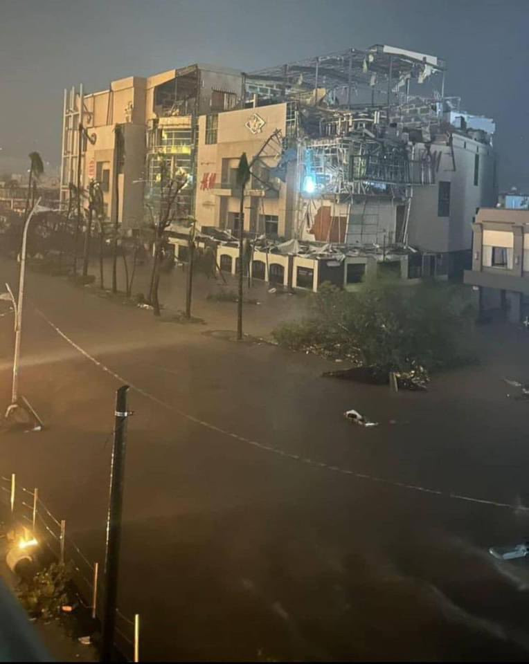
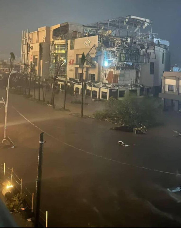
I thought this video is excellent and very instructive on the dangers of riding out a category five hurricane in a curtain wall system high rise building. If you notice on this image the edges of the building are completely shredded of all interior walls. The middle of the building is severely damage, but is only still in tact mostly because of the elevator and stair core (which is made of concrete and thus blocks the wind from completely shredding the middle). If you are in a high rise structure with glass exterior walls, you will not survive a category five unless you shelter inside the interior stairwell. Your bathroom or interior closet is not enough.
-
The time of duration and Intensity of the damage is still stunning to me, even for a 165 mph strike. The time of max winds was about two hours, and considering forward motion we are talking about maybe a 10-15 mile wide RMW. something that small in scale being violent enough to shred a major modern city is stunning. Perhaps slow movement factored in (other violent canes were moving faster than this). Unrelated but cyclone Tracy was mentioned. I will give Otis the nod over Tracy because of obvious primitive construction standards not being able to deal with winds greater than 115 mph on any level. That being said….I’m still stunned that a 950 mph storm flattened Darwin like that. It should also be noted all trees and vegetation was stripped. Steel power poles were also bent over. Otis and Tracy are very analogous situations though. Very tiny and violent cyclones that had very short duration periods. Otis obviously significantly more intense though.
-
Worst wind damage since andrew, and the more that comes out there is a case being made for worst urban wind damage ever produced by a tropical cyclone globally.
-
There will be studies and papers written about this storm, but the one thing that strikes me with this is the insane amount of damage it produced for being such a small cyclone with such little duration of max winds. There are a handful of curious cyclones that fit this bill (cyclone Tracy, charley, even Patricia in a weakened state, and to a lesser extent Andrew because it wasn’t micro sized). I wonder do Mets here think there is a certain increased violence or vorticity with these small cyclones that caused greater wind damage? Maybe I’m off base here, but interesting to think about.
-
This is spot in. If well constructed commercial establishments have people inside hiding from the wind……you know the wind is bad. Only cat 5 winds can do that. You can best believe low-rise wood framed buildings got shredded by this.
-
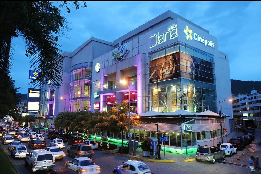
before and after photo of a commercial complex that is very well constructed. Photo comp seems legit
-
Considering the extreme wind damage and short duration of max winds because of the small size of the core, I see no issue with the 165 mph landfall. There is likely a chance it was even more intense just offshore before the eye started filling. Are there any pressure readings from landfall?