

WxMan1
-
Posts
746 -
Joined
-
Last visited
About WxMan1

- Birthday 07/27/1970
-

The Weekend Rule? Saturday 2/17 - The Icon Storm
WxMan1 replied to DDweatherman's topic in Mid Atlantic
Lots of dark blues on the 3km NAM on TT, almost from the get-go. All that snow falls within a 4-5 hour period. Definitely some near zero to negative theta lapse rates. -
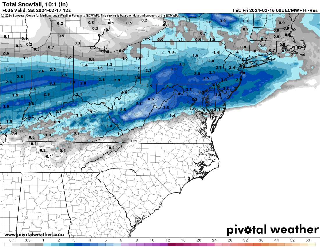
The Weekend Rule? Saturday 2/17 - The Icon Storm
WxMan1 replied to DDweatherman's topic in Mid Atlantic
00Z Euro, 10-1
-
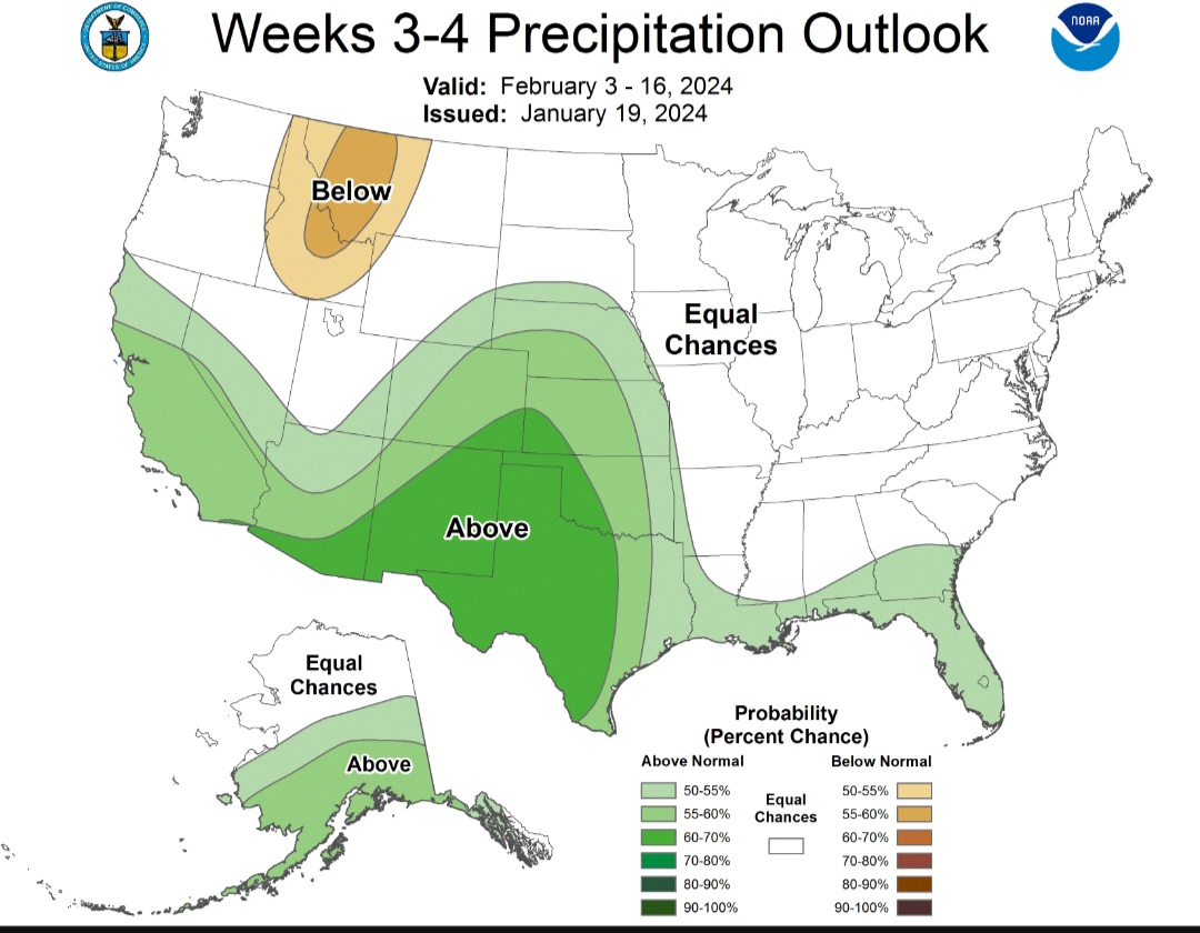
Jan/Early Feb Medium/Long Range Discussion Part 3
WxMan1 replied to WinterWxLuvr's topic in Mid Atlantic
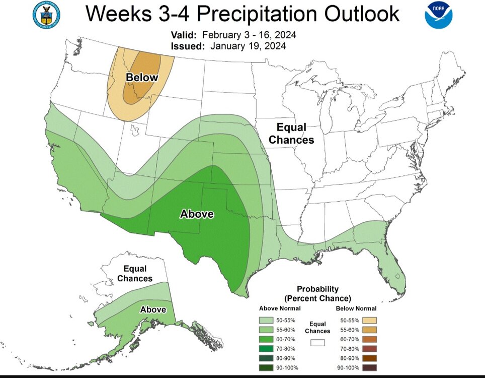
Latest CPC 3-4 week progs..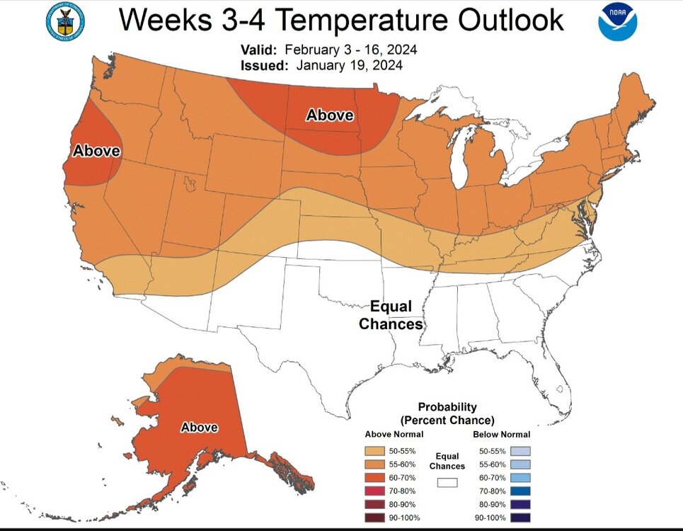

-
Getting more clumping flakes now here in Crofton, def a sign of nearing 0C somewhere along. Oh WAA, you were good today, so it's okay if you want to mix now..
-
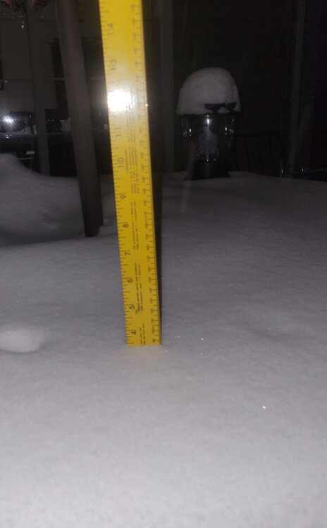
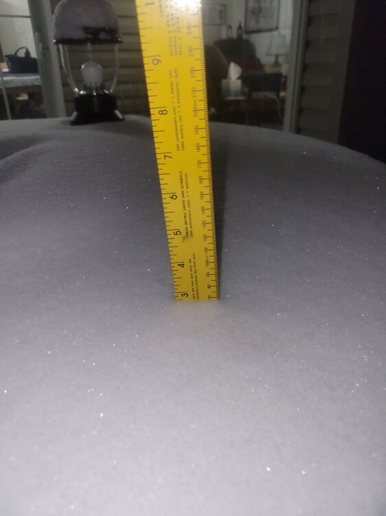
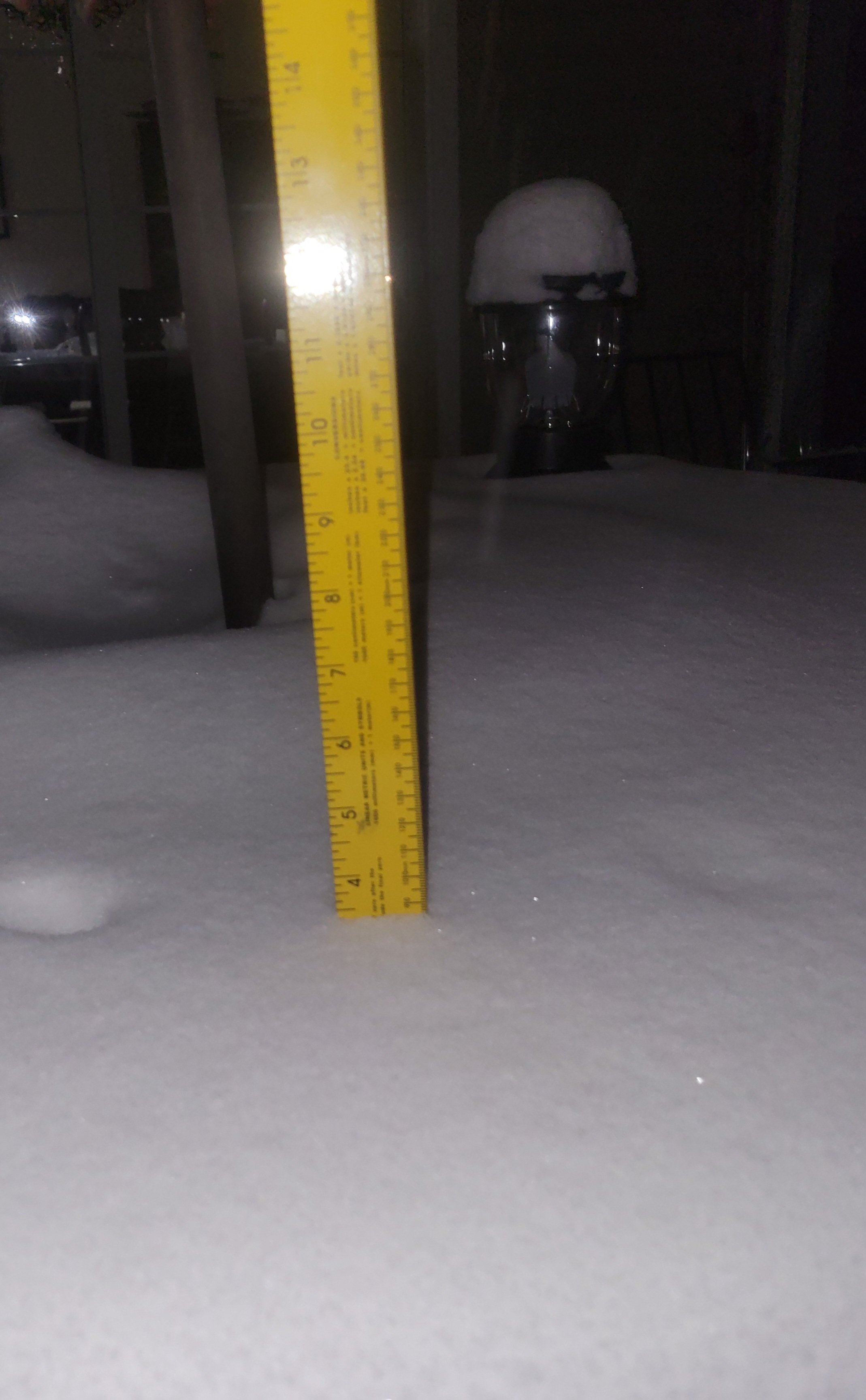
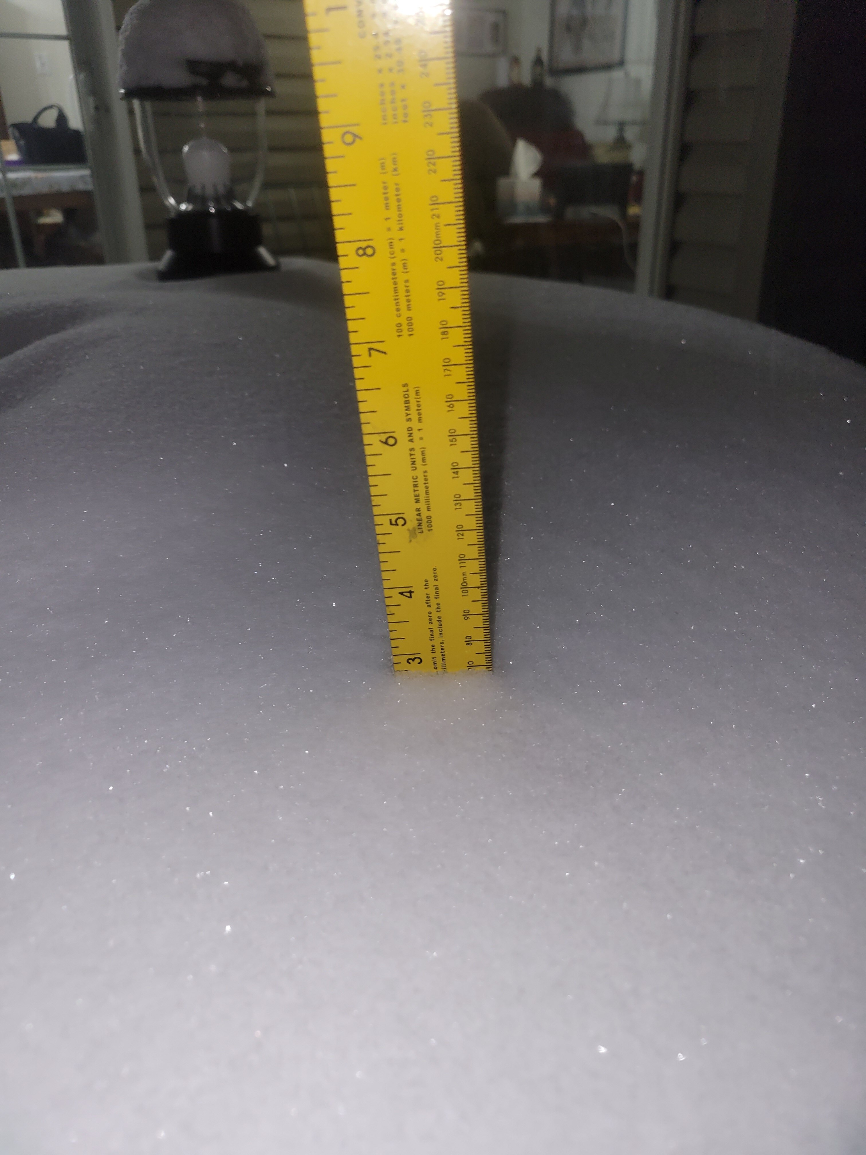
Just got done with shoveling (round 1). Just a little less than 3.5" here in Crofton, still snowing.
-
Very happy to work with these guys at WPC. And to you Scott and Pete: Perfect timing for 3 days off! Yeah baby!
-
A little less than 3" here in Crofton MD as of 9 pm.
-
Jan 15-16 Storm Threat Thread: The Return of Hope??
WxMan1 replied to stormtracker's topic in Mid Atlantic
Yeah...about that... The Rapid Refresh Forecast System -- RRFS -- will ultimately replace the current CAMs, including the NAM, HRRR, ARW, ARW2, and HREF suite. Many aren't on board with that, at least right now, given (a) the poor verification of the RRFS at this point, and (2) while the RRFS is an ensemble, it's ensembles are of the same system. Whereas the HREF is comprised of an ensemble of multiple (different) systems. Not looking forward to that day...hopefully it'll be put off. Rapid Refresh Forecast System GSL, NCEP/EMC, and other partners are working together on a project to design a single-model, convection-allowing, ensemble-based data assimilation, and forecasting system called the Rapid Refresh Forecast System (RRFS). This project aims to develop advanced high-resolution data-assimilation techniques and ensemble-forecasting methods while supporting the unification and simplification of the NCEP modeling suite around the FV3 model. (<-- But the FV3 has been pretty crappy verification-wise). Within the NOAA model unification effort, the RRFS represents the evolution of the NAM, RAP, HRRR, and HREF systems to a new unified deterministic and ensemble storm-scale system. This new system is targeted for initial operational implementation in late 2024 as a planned replacement for the NAMnest, HRRR, HiResWindows, and HREF. While the standalone regional (SAR) FV3 model is being developed for convection-allowing forecasting of a limited area (CONUS), other possible components of the RRFS are being tested now in the experimental, WRF-based High-Resolution Rapid Refresh Ensemble (HRRRE). Experimental runs of the HRRRE at GSL are focused particularly on: Improving 0-12 h high-resolution forecasts through ensemble-based, multi-scale data assimilation Producing spread in 0-36 h ensemble forecasts through initial-condition perturbations, boundary-condition perturbations, and stochastic physics. GSL is the owner and responsible for all data in this AWS S3 Bucket. -
Jan 15-16 Storm Threat Thread: The Return of Hope??
WxMan1 replied to stormtracker's topic in Mid Atlantic
I'd be wary of the NAM folks, even the 3km. Mainly because, well, it's the NAM (btw NCEP can't pull the plug on that model soon enough). I know it's in the shorter range when the NAM could actually be right. But look at some of the CAMS, including the latest (18Z) HREF are all farther south with the axis. I mean, look at the latest HRRR (the one Pivotal Wx map)...heaviest stays south! And were within 24-36 hours of go time. Will be interesting to see the 18Z GFS trends. ECMWF and UKMET, while not as far south with the max QPF and snow axis (into central VA), are definitely more muted with more widespread 2-3" for most, which is consistent with the NBM. Proceed with caution with the NAM3...thumb.png.4141109ff7771a15d66d64fa222da914.png)
.thumb.png.5b8e133ea991ec0415d601fe33db12aa.png)
.thumb.png.5eb36afe23cdd4ba5d717d07151a09c6.png)
.thumb.png.74d5d02c507f815ccab2c089f92c0d24.png)
-
Jan 15-16 Storm Threat Thread: The Return of Hope??
WxMan1 replied to stormtracker's topic in Mid Atlantic
Latest NBM v4.1 and v4.2 snow for Mon-Tue. Lots of 2-3" for the DMV. Not sure why the 4.2 version is a touch higher; might be because of SLR, but I'll take that one..thumb.png.dcf85161eb17f1e370413673d0e85702.png)
.thumb.png.f75a5d9c164673879344bfa7caa5a149.png)
-
Jan Medium/Long Range Disco 2: Total Obliteration is Coming
WxMan1 replied to Jebman's topic in Mid Atlantic
Should have posted this earlier, but the ECMWF ML FuXi model ("Foo-chi") is pretty optimistic for the Friday system as well. All totaled, at least ~10mm total, perhaps more since we don't really see the full resolution. That's like 0.4"-ish. Not bad. It should be noted that the FuXi was consistent in having 0.15-0.30" with the Mon-Tue system, which appears pretty reasonable now. https://charts.ecmwf.int/products/fuxi_medium-mslp-rain?base_time=202401140000&interval=12&projection=opencharts_north_america&valid_time=202401150000 -
Jan 15-16 Storm Threat Thread: The Return of Hope??
WxMan1 replied to stormtracker's topic in Mid Atlantic
GFS is solid but boy oh boy still quite a bit of spread when compared to the high res guidance. I mean we go from 4-6+ south of the DMV area on the GFS to heavier snow north towards Balt north with warm ~925 mb layer issues along/east of 95 here, esp in So. MD, per the NAM and high res guidance. All within 36, maybe 24 hours from go time. Weird. -
Jan 15-16 Storm Threat Thread: The Return of Hope??
WxMan1 replied to stormtracker's topic in Mid Atlantic
Frontogenesis with a narrow ribbon of enhanced isentropic ascent always seem to overperform with events like these when the Arctic chill follows suit. -
Since we're dealing with the NFL playoffs, the GFS vs. ECMWF battle to me feels like...
.png.82e680345dec85b849575f25f8d0e610.png)
-
Jan 15-16 Storm Threat Thread: Do we finally win or get Saltburned?
WxMan1 replied to H2O's topic in Mid Atlantic
Oh believe me, I did too! I think it's pronounced "Foo Chi".- 449 replies
-
- 2
-

-
- jinx
- kiss of death
- (and 3 more)


.png.37e1a2b58eed4cdd935c9576d0f044c4.png)
.png.49d5273f2dce7a1ea7e119718e6e93d7.png)
.png.aebfdc68c8829007f6723760e02fee84.png)
.png.2bbc02d736ec23ddc8bc57f8eb546bb3.png)
.png.dc81a69c2509b43563ef2b62c85303ed.png)
.png.078fbaeb2495e3a3be1fbfd3f2f0e220.png)
