aggiegeog
-
Posts
1,145 -
Joined
-
Last visited


-
Texas 2024 Discussion/Observations
aggiegeog replied to Stx_Thunder's topic in Central/Western States
Temps as low as 27 in East Texas this morning with a frost for the whole region. -
Texas 2024 Discussion/Observations
aggiegeog replied to Stx_Thunder's topic in Central/Western States
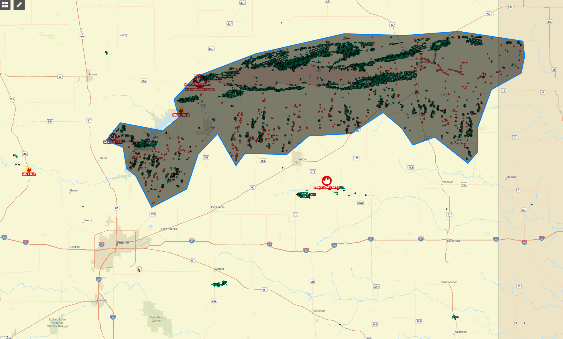
Smokehouse Creek Fire is now over 1M acres. The largest fire in Texas history surpassing the East Amarillo Complex Fire which burned 900k acres. -
Texas 2024 Discussion/Observations
aggiegeog replied to Stx_Thunder's topic in Central/Western States
The fire situation NE of Amarillo is horrible. The main complex consisting of Windy Deuce Fire, near Lake Meredith, and Smokehouse Creek Fire, started near Stinnett and now crossing into Oklahoma, has officially burned over 500k acres. If you measure the the perimeter of hot spots this morning from this complex you get something closer to 1.5m acres. There are other large fires scattered around the Panhandle also.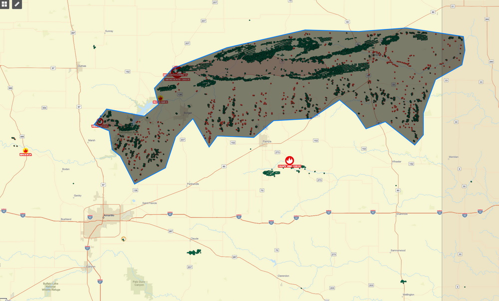
-
Texas 2024 Discussion/Observations
aggiegeog replied to Stx_Thunder's topic in Central/Western States
That early March 2014 In Tyler featured a night of heavy thundersleet followed by a day with highs around 20 and lake effect flurries. -
Texas 2024 Discussion/Observations
aggiegeog replied to Stx_Thunder's topic in Central/Western States
The freezing line is pushing SE it's down along Hwy 80 into Wood County then up towards Texarkana. -
Texas 2024 Discussion/Observations
aggiegeog replied to Stx_Thunder's topic in Central/Western States
Would t be surprised to see a WWA for NW half of N TX and possibly expanded a bit SE from there. -
Texas 2024 Discussion/Observations
aggiegeog replied to Stx_Thunder's topic in Central/Western States
Temps in NE TX range from 6 to 15 this morning and shaded spots are still very slick. -
Texas 2024 Discussion/Observations
aggiegeog replied to Stx_Thunder's topic in Central/Western States
Looks like Tyler ended up down to 13F this morning. My house got down to 11F in Lindale. Tyler is going to end up with 54 hours at 20 or below and by tomorrow Tyler will be around 95 hours below freezing. -
Texas 2024 Discussion/Observations
aggiegeog replied to Stx_Thunder's topic in Central/Western States
NWS with the huge adjustment to afternoon temps here from 25 to 17F. We are going to go over 50 hours consecutive without temps >20F. Today will set the low max for the date which was 33, temp reached 19 early this morning before falling into mid teens for the afternoon. Today will be just the 4th Jan day ever on record in Tyler with a sub 20 high. Tomorrow has a good chance for the record low of 15 with a forecast of 12. Tomorrow has a shot at the record low max of 26 with forecast of 26. If the next front has can take better aim straight down the Plains the Sat record low max of 27 is reachable. -
Texas 2024 Discussion/Observations
aggiegeog replied to Stx_Thunder's topic in Central/Western States
We are now at over 24 hours of continuous light snow. Only 1/4 to 1/2 inch accumulations so far here though. Did just have a heavier burst. The snow is falling from below the radar beam over here in our semi radar hole between FTW and SHV. -
Texas 2024 Discussion/Observations
aggiegeog replied to Stx_Thunder's topic in Central/Western States
In Lindale got around 1/4" of mainly sleet. In between sleet showers have had constant flurries since yesterday morning. never got above 18F yesterday during the day. -
Texas 2024 Discussion/Observations
aggiegeog replied to Stx_Thunder's topic in Central/Western States
Winter Storm Warnings have been expanded south in East Texas down to Jacksonville, Nacogdoches and Center: Winter Storm Warning URGENT - WINTER WEATHER MESSAGE National Weather Service Shreveport LA 1210 PM CST Sun Jan 14 2024 LAZ010>013-TXZ149>153-151200- /O.UPG.KSHV.WW.Y.0001.000000T0000Z-240116T0000Z/ /O.EXA.KSHV.WS.W.0001.000000T0000Z-240116T0000Z/ De Soto-Red River-Bienville-Jackson-Cherokee-Rusk-Panola- Nacogdoches-Shelby- Including the cities of Mansfield, Stonewall, Logansport, Coushatta, Martin, Arcadia, Ringgold, Gibsland, Jonesboro, Jacksonville, Rusk, Henderson, Carthage, Nacogdoches, and Center 1210 PM CST Sun Jan 14 2024 ...WINTER STORM WARNING IN EFFECT UNTIL 6 PM CST MONDAY... * WHAT...Heavy mixed precipitation. Snow accumulations of less than one inch, sleet accumulations of around 1/3 of an inch and ice accumulations of one tenth to one quarter of an inch. * WHERE...Portions of north central and northwest Louisiana and east Texas. * WHEN...Until 6 PM CST Monday. * IMPACTS...Plan on slippery road conditions. The hazardous conditions could impact the morning or evening commute. PRECAUTIONARY/PREPAREDNESS ACTIONS... If you must travel, keep an extra flashlight, food, and water in your vehicle in case of an emergency. The latest road conditions for the state you are calling from can be obtained by calling 5 1 1. -
Texas 2024 Discussion/Observations
aggiegeog replied to Stx_Thunder's topic in Central/Western States
We have been getting flurries and light freezing rain since about 8am. Roads getting slick already. Temp 16F. So far a glaze of ice and dusting of snow. Much more to come over next 24 to 36 hours. -
Texas 2024 Discussion/Observations
aggiegeog replied to Stx_Thunder's topic in Central/Western States
During most of the event my area along I-20 in East Texas will have a classic dendritic growth zone at around 500mb but a large dry and warm zone centered on 700mb then saturation but warm at 850mb with temps sharply falling from 850mb to the surface with full saturation. So low and warm cloud deck and precip freezing as it falls equals freezing drizzle when rates are low and sleet when rates are higher. Some snow as the cloud deck cools towards tomorrow morning. QPF here seems between 0.15-0.35" which should be around 1" of mixed accumulation. Precip starts late morning tomorrow and lasts until midday Monday. -
Texas 2024 Discussion/Observations
aggiegeog replied to Stx_Thunder's topic in Central/Western States
I do not notice a significant drying trend and maybe even an upward trend. I am NE TX focused admittedly. Seems like a south trend is starting as globals recognize they have the air mass boundary too far north. I would expect this south trend to continue on globals. Thankfully meso scale models are coming more into range to clear things up. A touch colder and the most north of I-20 stay snow for most of the event which could see a few spots hit over 6" of snow.