BeauDodson
-
Posts
417 -
Joined
-
Last visited
About BeauDodson

- Birthday May 8
-

Summer 2024 Medium/Long Range Discussion
BeauDodson replied to Chicago Storm's topic in Lakes/Ohio Valley
They batted about 80% last year with long-range outlooks. They have come a long way since their infancy years ago. Their farm and garden videos, GFS analysis, and EC analysis videos are excellent. They have an amazing team of meteorologists. Years ago, I felt the same way. But, over time, they have become a great company!
-
Summer 2024 Medium/Long Range Discussion
BeauDodson replied to Chicago Storm's topic in Lakes/Ohio Valley
You can see where the ridge set up shop over the last three weeks. The haves and have-nots. Too much rain and too little rain.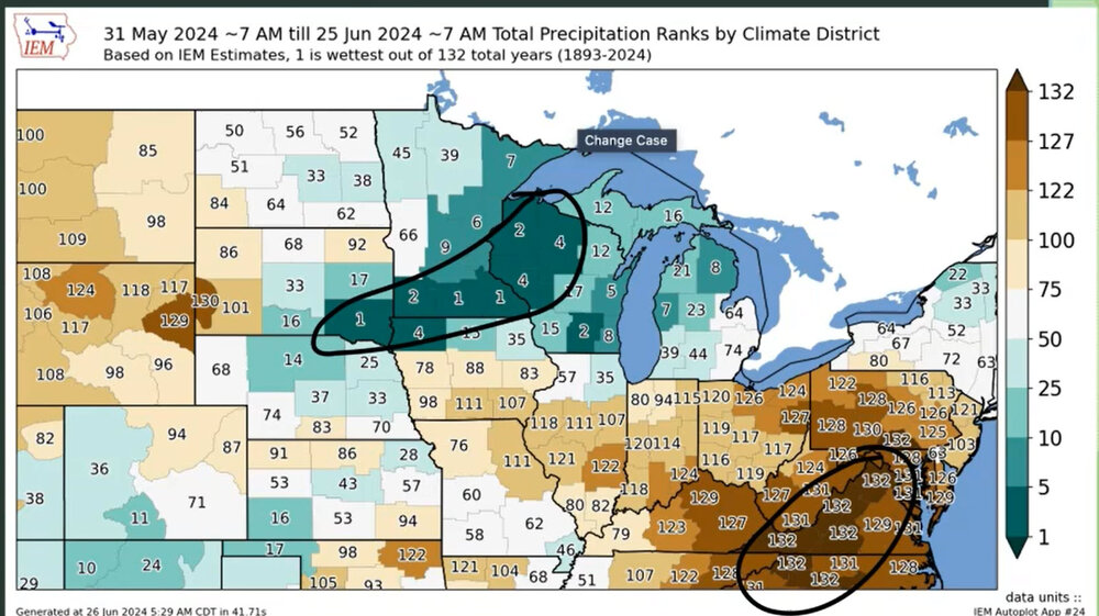
-
Summer 2024 Medium/Long Range Discussion
BeauDodson replied to Chicago Storm's topic in Lakes/Ohio Valley
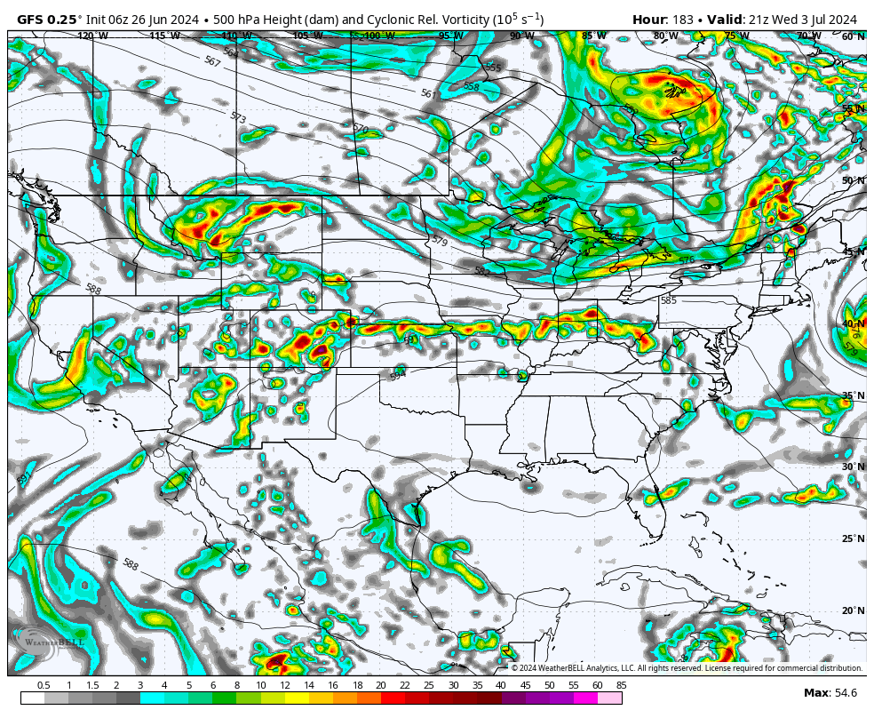
Our long-range team has a great video today about July's weather. A bit of a nail-biter for the Ohio Valley. We will have to see where the ridge sets up. Would not be surprised to see the MCS train produce pockets of ten or more inches of rain. These videos can be viewed on our www.weathertalk.com app. If you don't live in our area, then choose any given county and then download the app to view the daily videos. -
Historic Lake Effect Event?! 11/17-11/21
BeauDodson replied to BuffaloWeather's topic in Upstate New York/Pennsylvania
It appears the GOV is closing most roads at 4 PM. That shuts me out. Disappointed, but it is what it is. I have to be at NWS conference this morning. Otherwise, I would have left last night. Be careful, everyone. Enjoy the white gold. Looking forward to the photos and videos. -
Historic Lake Effect Event?! 11/17-11/21
BeauDodson replied to BuffaloWeather's topic in Upstate New York/Pennsylvania
What Discord room is that? Thanks -
Historic Lake Effect Event?! 11/17-11/21
BeauDodson replied to BuffaloWeather's topic in Upstate New York/Pennsylvania
Hoping I can come in from the south tomorrow afternoon. Sounds like they will close it. Unsure another way in.
-
Historic Lake Effect Event?! 11/17-11/21
BeauDodson replied to BuffaloWeather's topic in Upstate New York/Pennsylvania
What are you driving once there? -
Historic Lake Effect Event?! 11/17-11/21
BeauDodson replied to BuffaloWeather's topic in Upstate New York/Pennsylvania
Interesting setup for LES. I remember the 2000 event. Incredible totals. Quite a bit of thundersnow. I'm thinking about chasing this one. -
Winter 2022/23 Short/Medium Range Discussion
BeauDodson replied to Chicago Storm's topic in Lakes/Ohio Valley
Is this the correct thread for the Buffalo area? Thanks -
Devastating tornado strikes Joplin, Missouri
BeauDodson replied to Hoosier's topic in Weather Forecasting and Discussion
Hi JoMo, I thought about you on the anniversary of the tornado. It is hard to believe that it has been ten years. It seems like yesterday. I don't come on the forums very often, but was browsing it this morning and noticed this thread was still active. I hope you are doing well. I can't imagine the amount of trauma associated with an event like this. I can only compare it to what I saw after Katrina and Rita. It is hard to fathom so much destruction and loss of life. -
Devastating tornado strikes Joplin, Missouri
BeauDodson replied to Hoosier's topic in Weather Forecasting and Discussion
Was thinking about you today. Popped into the forum to see if this thread was still alive and well. I see that it is. I agree, it is hard to believe that it has been five years. Hope you are doing well. -
Devastating tornado strikes Joplin, Missouri
BeauDodson replied to Hoosier's topic in Weather Forecasting and Discussion
Weather Brains had an interesting guest on recently. Dr. Jason Persoff. He recounted his experience in Joplin immediately after the tornado struck the city. http://weatherbrains.com/weatherbrains/?p=2138 -
Devastating tornado strikes Joplin, Missouri
BeauDodson replied to Hoosier's topic in Weather Forecasting and Discussion
I agree 100%. I have caught errors on this subject more than once. It is a concern. I am going to bring it up again with our local office. Especially after the answer I was given earlier this year. -
Devastating tornado strikes Joplin, Missouri
BeauDodson replied to Hoosier's topic in Weather Forecasting and Discussion
Although I can't answer for him I find the service assessments extremely valuable. I read them all - have them all printed out - keep them here on hand for review. I think the NWS, emergency management, media, and others read them - utilize them - take them for what they are. I learn something from each assessment and make changes accordingly. From talking with others - they do the same. The process isn't perfect - it is evolving - will continue to evolve. The more we learn - the more we realize we have a lot to learn. -
Devastating tornado strikes Joplin, Missouri
BeauDodson replied to Hoosier's topic in Weather Forecasting and Discussion
Unfortunately this book is being sold in many outlets - to the public. I am not sure how someone outside of the meteorological community would view this. It makes the NWS look incompetent. I do agree with Mike on some of the topics brought up within the book. Some of them are the same concerns raised in the service assessments. Of course service assessments are not read by the general public. If this publication was for internal purposes then I would view it as a severe lashing against the NWS, some in the media (although they are excused somewhat in the book because they were parroting what the NWS said), and emergency management officials who didn't blow the sirens properly. For a publication like this to be sold to the public - not sure it is helpful or useful. It does strongly promote their private warning service. I am not sure how many times their private warning service was mentioned - but several times. Emphasis was added that they got the track right and the NWS got the track wrong. Critique is important within the weather community - there are several private and semi-private forms to do just that. Critique can be important in moving everyone forward - improving products issued for the public - improving siren policies - other. However, I would agree with some others with the same sentiment that the book is a bit disappointing in the approach. When one group/agency makes another group/agency look like fools - with little mercy - then eyebrows are raised that there is some sort of agenda at hand. I am afraid this is what the book left me wondering. The book raises some important points - valid concerns - items of interest. The approach, though, was disappointing. The NWS had a very difficult job that day - emergency management had a very difficult job that day - the manner in which the storm formed, exploded, evolved made for a perfect storm of sorts. Unfortunate and so was the outcome.