hawkeye_wx
-
Posts
5,925 -
Joined
-
Last visited
1 Follower

About hawkeye_wx

- Currently Viewing Topic: April 2024 General Discussion
- Birthday 10/10/1974
Recent Profile Visitors
6,707 profile views


-
It looks like our frost chances may be done for the year. The NWS has bumped us up to upper 30s the next couple nights and removed the mention of frost. The next 2+ weeks look mild to warm.
-
GEFS 15-day The drought is gradually being chipped away around here. Last summer we peaked at "exceptional". We dropped to "extreme" for the winter. Last week we dropped to "severe". The next two weeks could eliminate the remaining "extreme" drought in Iowa and drop us down to "moderate".
-
Models continue to show a very active pattern from late April into early May.
-
0.36" of rain here today, pushing my April total up to 2.62".
-
I finished with 0.67" of rain. That's not bad, but less than what models have been showing for days. Thunder was minimal. I at least got to see some heavy rain for the first time this year.
-
There have been a few warnings to the south, but it's just a band of showers with embedded lightning moving into my area. There has been zero sunshine across eastern Iowa today.
-
Cedar Rapids made it to 86º today, pretty toasty. Des Moines hit 88º. The sw corner of Iowa made it to 90º.
-
I should finally get my first thunderstorm of the year Tuesday. All of our rain so far this season has been light to moderate cold rain.
-
A total solar eclipse will occur in October 2153 and Cedar Rapids will be in the exact center of totality. I wish we could move that up by 100 years.
-
My three day precip total is a solid 1.37". My snow total is only 0.3".
-

4/2-4/3 Significant Late-Season Snowstorm (WI/MI)
hawkeye_wx replied to Geoboy645's topic in Lakes/Ohio Valley
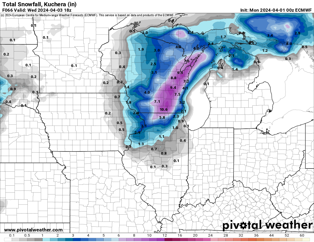
We were only able to get a couple tenths as the snow struggled to accumulate faster than it melted. There is much better overlap between the heavy precip and cold air up in Wisconsin. -
4/2-4/3 Significant Late-Season Snowstorm (WI/MI)
hawkeye_wx replied to Geoboy645's topic in Lakes/Ohio Valley
Cedar Rapids just switched to snow. -
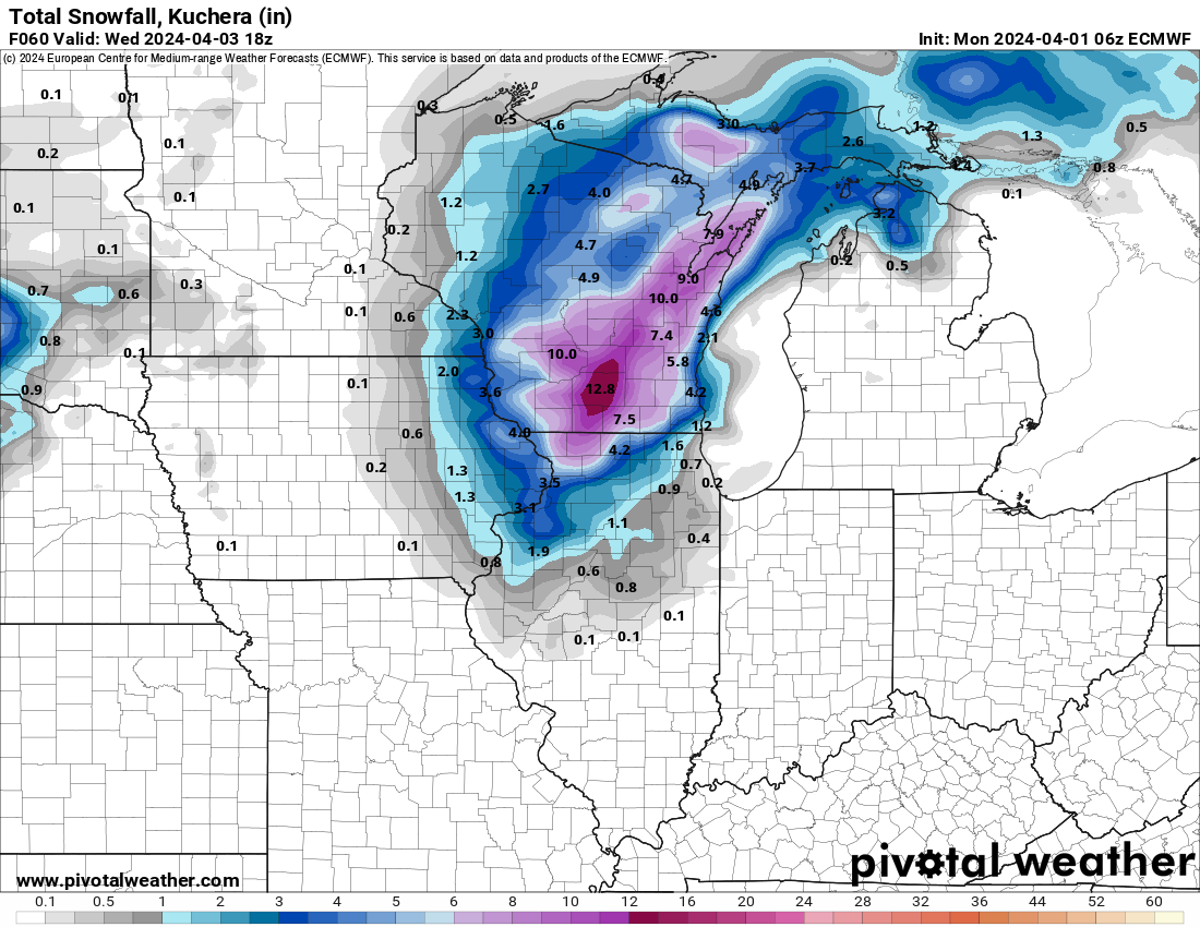
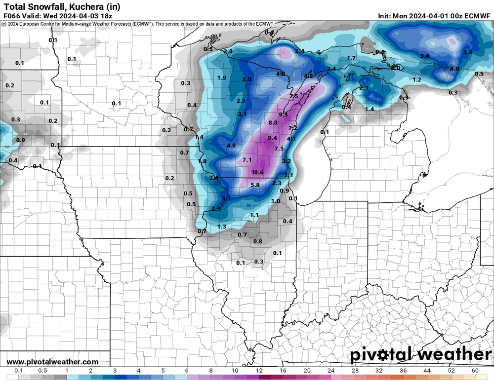
06z Euro

-
The early to mid week storm has trended nw this evening. The Euro, in particular, has shifted all the snow back west into Wisconsin.
-
Unfortunately, the GFS is an outlier. The other models are farther south and less amped, so just showers here.