Jonathan
-
Posts
1,466 -
Joined
-
Last visited
About Jonathan

- Birthday 04/16/1988
Recent Profile Visitors
3,898 profile views


-
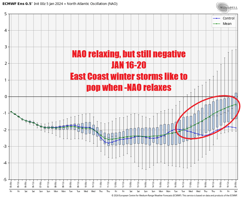
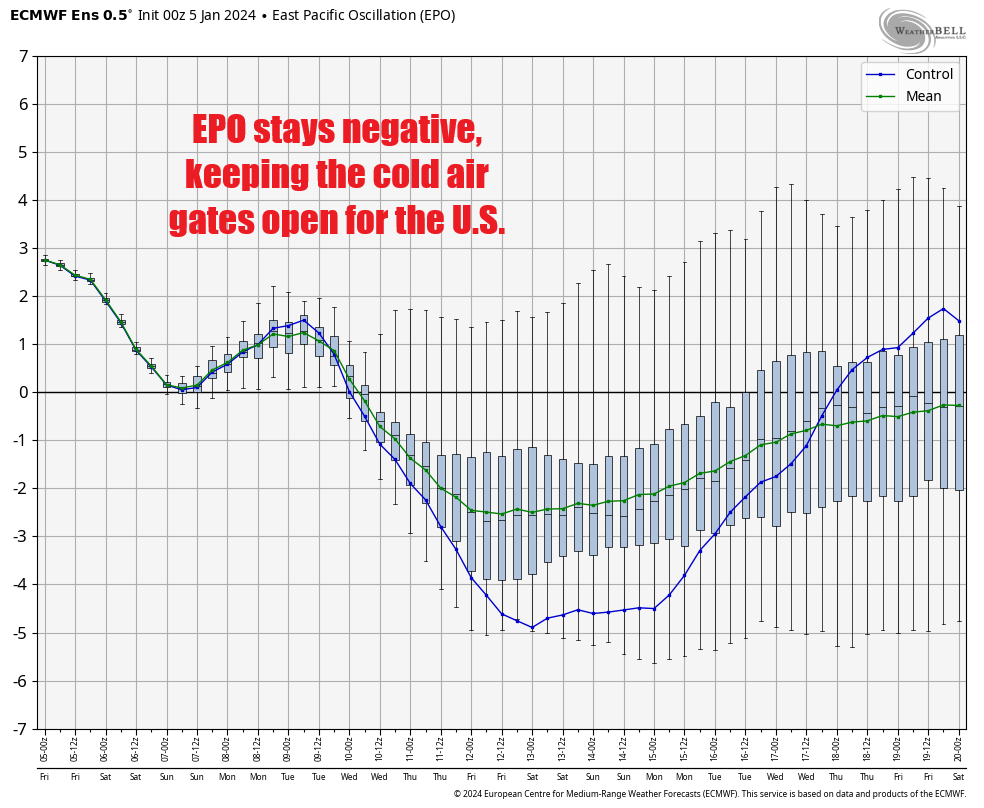
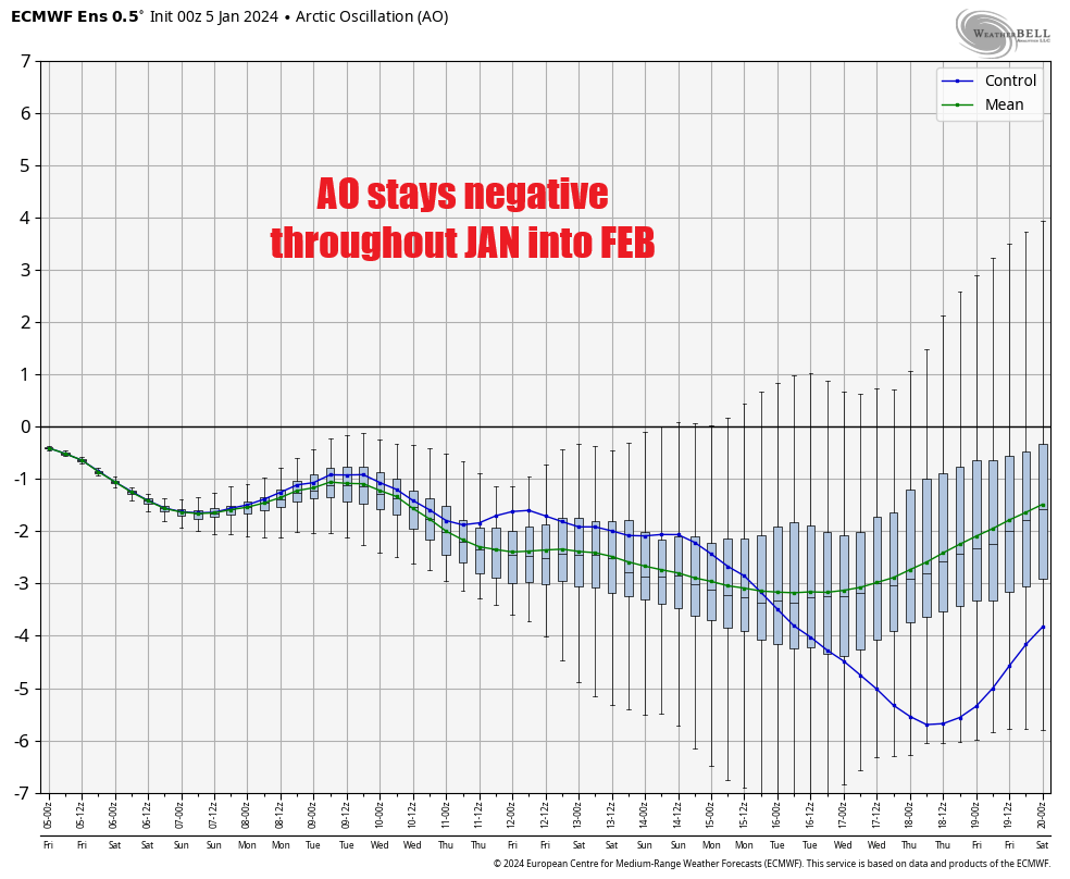
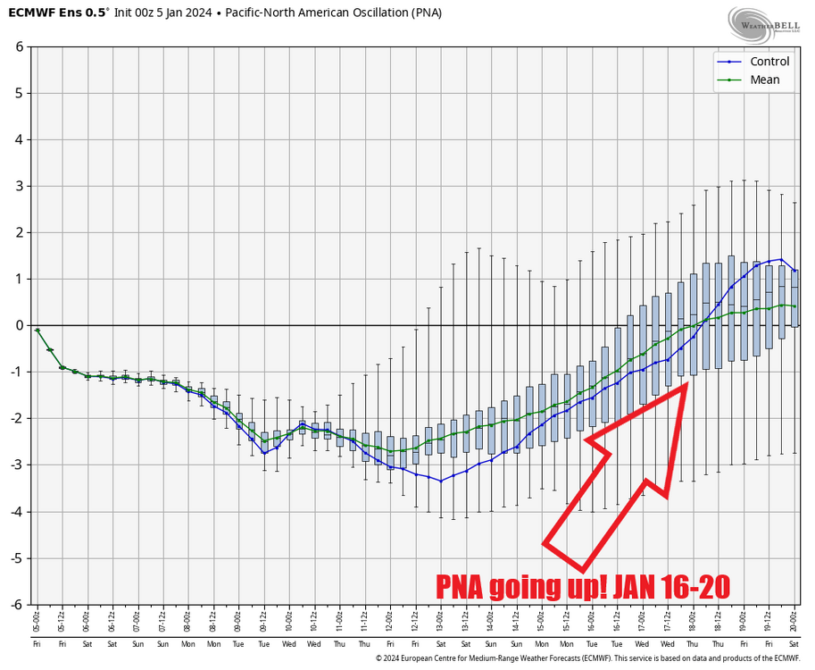
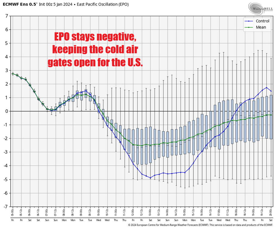
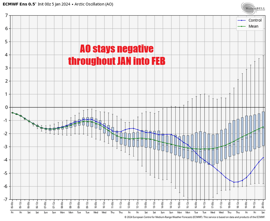
To build upon this (I'm not J Wall btw lol), if we look at the Teleconnections from the 00z EURO Ensemble, we see hints of this also. First, the PNA. It's been a huge thorn in our side but it finally looks to move positive by JAN 20. This is huge for us, especially in combination with a big -NAO that looks to relax a bit (but still be negative) towards the same period. Per Tomer Burg, winter storms in the eastern U.S. tend to pop up when a -NAO relaxes a bit and we see this happen in that JAN 17-20 timeframe as well: Rounding out our other main teleconnections, both the EPO and AO look to remain negative throughout the period as well. With all that said, perhaps we sneak out a winter storm for the southeast (and possibly up the east coast, Miller A style) in that JAN 15-20ish period.

-
Southeast Sanitarium - Winter 23/24 Edition
Jonathan replied to eyewall's topic in Southeastern States
Can't even get a good ZR event here anymore. In the last 12 hours, my .25"+ of ice is looking real .10"ish. By tonight it'll be all rain and 38°. Until we get a +PNA, you can kiss any chance of snow goodbye in the southeast, and not a single piece of data hints at a +PNA developing at any time. MJO is heading into warm phases for the dead of winter. It's ok, Fab Feb will save us. Always the best month in a Nino! Except it's barely a Nino anymore and will be a Nina by late-Feb. I also love watching Texas and Arkansas rack up on snow while being 5-10 degrees of longitude south of me. Storm track is from Louisiana to Pennsylvania. I'll be glad when climate change puts us all out of our misery. Hopefully it accelerates even more than it already is. Get me off this stupid, burning rock as quickly as possible. Serenity now. -
Then when we get to 1/12, we'll have kicked the can another two weeks down the road and saying "yeah, it sucks we lost the first 1/3 of winter but the pattern by the end of the month looks promising." Why does anyone put themselves through such torture. The snow line will be north of Kentucky in 5 years or less. With that said, the 12z Euro had 15/50 ensemble members with accumulating snow in the foothills and western piedmont (I looked at KMTV Martinsville VA since it's close enough to the mountains but is still considered western piedmont. So there's that, I guess.
-
It's beautiful. Frame it, because we'll never see it under 240hr.
-
Super Ultra Mega Generational Nino on the way to rain (literally) on everyone's parade for the next two years.
-
Winter is coming...
-
You know what WON'T trend NW? That system everyone was watching for 12/26. It's now out to sea on all data and you can kiss that goodbye.
-
Jonathan changed their profile photo
-
A tale as old as time. We see this happen with EVERY potential system DEC-FEB every winter. Climate change and ENSO background state will outweigh every positive teleconnection you can have. Ninas gonna Nina. There's a reason we don't get cold and snow in Ninas. We get baited by these computers EVERY time and swear we won't do it again. This "cold shot/cold pattern" will be a 2-day deal on the models by early next week and we'll be wondering why we're running the AC at Christmas/New Year's yet again. One thing I REALLY can't believe is that the models even fooled Brad Panovich. He's usually rock-steady in the "nothing's gonna happen, social media is just being crazy with snow maps." He took the bait yesterday, made a YT video and everything. That's something you don't see often. The models get us Every. Single. Time. Yesterday: Snow Today: Mix Tomorrow: Rain The Next Day: Tornado outbreak GFS folds to Euro EVERY. TIME. Winter is so awesome!
-
Next!
-
GFS unfortunately is on an island. Worse than an island, a different solar system. It has zero support and until it gets some it must be treated for what it always has been; garbage. Waste of taxpayer money.
-
Somebody shut this model down. I have never seen a more insane setup for a dreadful Euro run in all my days.
-
YIKES! 0z Euro absolutely craps the bucket with a warm rainstorm 12/22. GFS Ensembles were awful as well, cutting VA's snow totals in half and almost removing them completely for NC.
-
The 18z GEFS is much more robust with the extent of the freezing rain Thursday, getting all the way down into central NC vs the 12z GEFS which barely made it to the NC border. Interesting.
-
If the 18z GFS happens I might die. Holy smokes what a teaser.
-
It's a real shame that the MJO is basically allergic to phases 7-8-1 anymore. You hardly ever see it in general, and you almost never see it in winter. I'm guessing this has to do with climate change causing warmer SSTs in certain areas causing more tropical forcing "there" than elsewhere.