
KChuck
-
Posts
413 -
Joined
-
Last visited
About KChuck

Recent Profile Visitors
2,223 profile views


-
Would be interesting to see that in the different tilt radars.
-
Thanks for the advice! Wife and I saw our first one with the 2017 version in Greenville, SC. She didn't want to go but went to keep me company because she knew how much I enjoyed astronomy. I volunteered several years at the Keystone College Thomas Cuppilari observatory in Fleetville, Pa. I thought I knew so much about eclipses and what to expect after leading slide shows and discussions for so many years...hah! My wife burst out crying when totality came and you could look directly at the sun. My daughter, who doesn't see why people make such a fuss over such events, went on her social page that evening and posted to her friends an apology to all of the eclipse chasers saying that the eclipse was awesome. It's still too early to throw in the towel. My wife has an autoimmune disease that affects her muscles and is on a special diet which complicates traveling. I'm not worrying about the weather until Thursday evening. By then everyone should have a fairly good idea what we're up against. I have until 3pm Friday to cancel reservations and get a full refund so that takes some of the pressure off.
-
Looks like everything may be coming up roses for you and Arkansas after peering at the latest eclipse time guesses. New York state looking like it's being infested with weeds as far as high, mid, and low level clouds go. Good luck to you! If nothing changes looks like Mrs and I will be canceling our New York reservations Wednesday and sitting this one out.
-
Unfortunately it seems to be headed in the other direction for the Northeast.
-
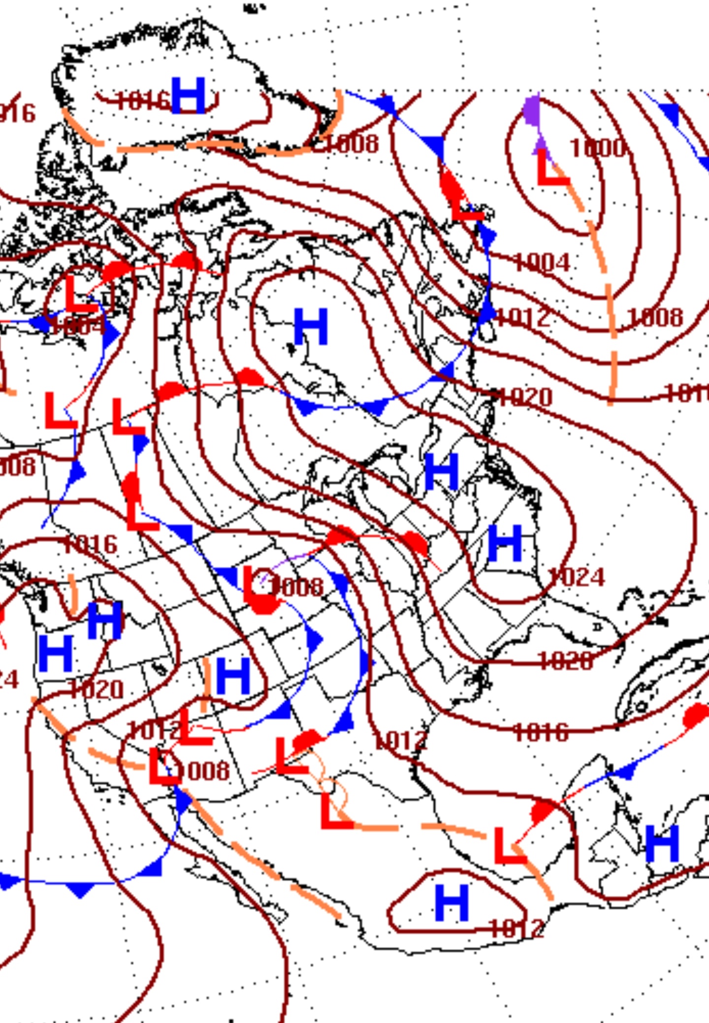
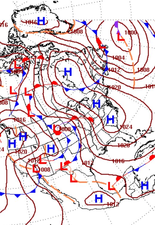
Anticipated map of fronts/pressures produced last night for 8am edt Monday morning. Write up from the WPC. "Overview and Guidance/Predictability Assessment... Model guidance seems reasonably agreeable with the overall pattern through this forecast period as highlighted by formation and subsequent slow transition of a massive Omega style blocking pattern over the lower 48 and vicinity starting by later this week. The large scale features consist of an upper trough/closed low over the Northeast finally ejecting into the Atlantic early next week, another upper low tracking from the eastern Pacific into the West later this week pivoting into the north-central Plains early next week with ridging ahead of it, and additional energy digging into the West by next Sunday-Tuesday. Forecast spread and uncertainty are generally below normal overall, but does increase into early next week with the ejection of system energies from the West to the Plains along with complex associated cyclo/fronto genesis transitions. Forecast spread is certainly within typical levels for the Days 6-7 period, but has implications for frontal positions (and cloud cover for the eclipse in the central to east- central U.S.)."
-
Buffalo NWS 4:23pm disco... "LONG TERM /FRIDAY THROUGH MONDAY/... An omega blocking pattern will very gradually slide east across the CONUS near end of this week and into early next week. Initially on Friday, deep troughing in the form of a closed low will be located over the Northeast to the eastern Great Lakes as well as west of the Rocky Mountains, with a strong ridge of high pressure in the middle over the central Plains. Unsettled weather will persist across the forecast area though gradually wind down Friday through Saturday as the eastern trough maintains a moist, cyclonic flow across the region. 850H temps may initially be just cold enough around -8/-9C for some lake enhancement Friday morning, though will likely warm a few degrees through the day to effectively shut off this response. This being said, will continue to nudge PoPs above NBM this period as the continued influx of moisture and shortwave ripples aloft should maintain at least some shower activity across the region. Chances for precip will be highest across the higher terrain areas east of Lake Erie and across the Finger Lakes where orographic lift will be a factor. In regards to p-type, very marginal boundary layer and sfc temps will support a mainly elevation-based mix of rain and snow Friday through Saturday morning, though the strong early April sun angle should limit the ability for any additional snowfall to stick during the daytime hours. The area should begin to dry out Saturday night as the closed low over New England weakens and shifts out into the northwestern Atlantic, and the ridge to the west builds east into the Great Lakes region. As the attendant surface high moves over and eventually east of the forecast area, clearer skies and warming temps will make their way to the region by Sunday. Now on the fringe of our routine forecast range, many eyes will be on Monday, when the path of totality for the highly anticipated 2024 Solar Eclipse will cut through much of our forecast area. Deterministic and ensemble model guidance are in good agreement on the longwave pattern early next week, with the sensible weather across our area being dry and on the warmer side, featuring high temperatures mainly in the 50s. At this range however, uncertainty is very high in the amount of total cloud cover and how it will be structured, especially across western NY. Long-range guidance suggests increasing mid and/or high clouds through the day, though whether or not these would be dense enough to obscure any view of the eclipse cannot be determined at this time. Stay tuned!"
-
Contingency plans must be laid out based on the best available prognosis ASAP. Also cancelations must be done early for the case of any washouts.
-
An earlier Buffalo NWS disco said that an omega block was keeping the area clear the prior weekend and that eclipse cloudiness would be dependent upon how fast that block breaks down.
-
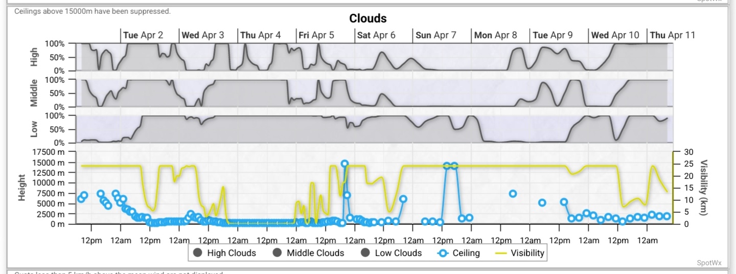
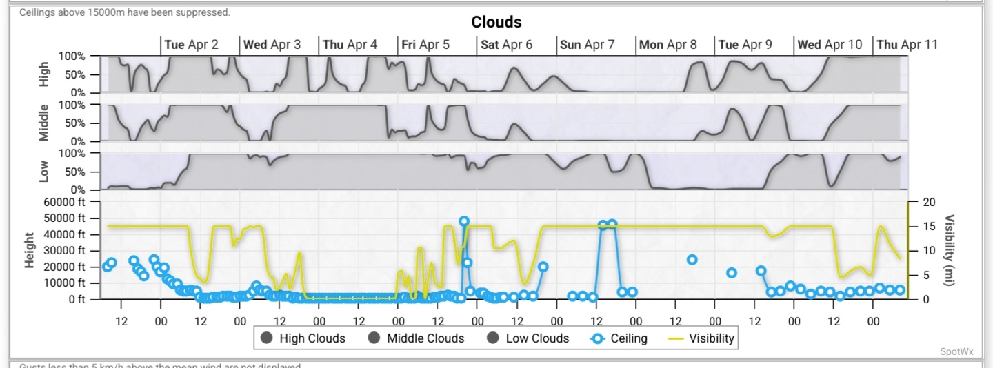
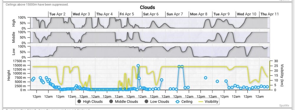
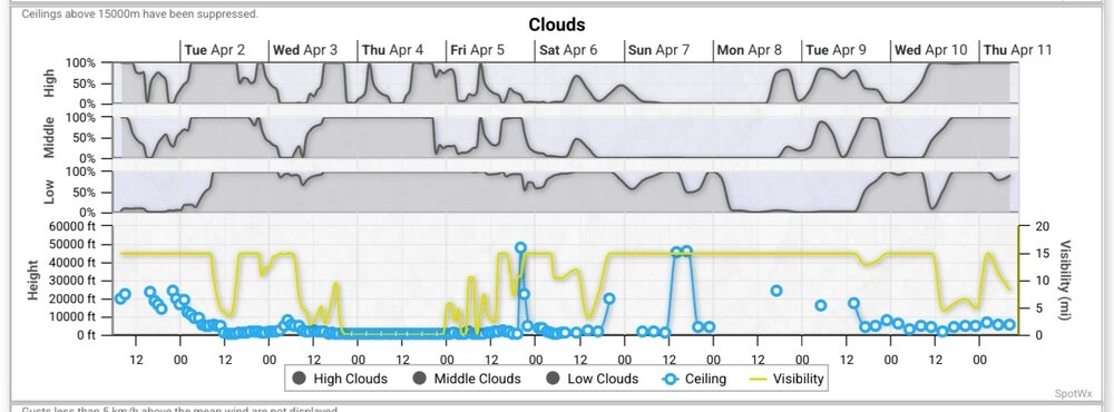
If you go to https://spotwx.com and enter your location you will be presented with a listing of model site links. Go down and click on the 10 day GFS link. This will present you with a forecast of high, mid and low level clouds. This is the model that is in play this far out from the eclipse. You can also view the 10 day Canadian GDPS. This is the current 10 day GFS for Medina, NY. I added another screen shot as I forgot to change units.
-
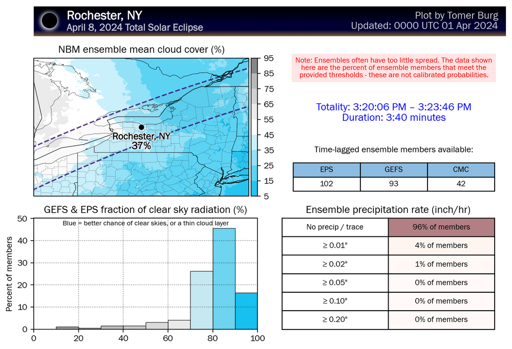
Yes. In this model visual you want more blue. I'm set up for the Medina NY area. My take is that I'm looking at high cirrus. As you said, graphics are implying that you get better odds the further east that you go in New York. I've got my fingers crossed. I'm relying at this point on the Buffalo NWS for me. I'm willing to scurry to catch a better view, but with a forecast of 2.5 million people in the western New York area I have to wonder how many of those will have the same idea. I'm not willing to get into the middle of an Interstate parking lot again after my experiences post 2017 eclipse.
-
Updated Buffalo NWS disco for eclipse day... "While beyond our normal 7-day forecast... The highly anticipated 2024 Solar Eclipse will occur Monday, April 8th in the afternoon. Model and ensemble guidance continue to suggest dry weather for Monday with high pressure surface and aloft over the eastern Great Lakes and Ohio Valley, however it is FAR too early to forecast cloud cover with any confidence or reliability."
-
Yep. The thing that I've been worried about since I made my eclipse reservations back last November was a big weather system event. Often when a block breaks down something like this happens. But hey... it's the weather. In two days it will change, right?
-
Um, if I'm reading this correctly, hope is fleeting for the whole US eclipse corridor with the exception of upper tier New York. The darker the color the better chance for clouds. Both the Canadian and American 10 day models, which I've been following for almost the past week, flipped and are now showing better than 50% cloud cover for the area that I'm focused on... western New York. Buffalo NWS stretched out their 7 day disco with the following... "Mainly dry weather will return late Friday night and remain in place through the upcoming weekend as a stout omega blocking pattern looks to set up across the Lower 48, with deep troughing lingering off the East Coast and western CONUS and a stout ridge over the Midwest and Great Lakes. This will also bring about a strong warming trend to the forecast area into next week, with seasonable temps Saturday warming to above normal by Sunday. While beyond our normal 7-day forecast...The highly anticipated 2024 Solar Eclipse will occur Monday, April 8th in the afternoon. FAR too early to give any semblance of an accurate sky cover forecast at this point, though cloud cover on Monday will likely hinge on how quickly the aforementioned omega blocking pattern begins to break down early next week."
-
I can vouch to the effect. Wife and I went to Greenville, SC where my daughter lives for our first total eclipse. I remember telling my wife that it wouldn't be too bad with the scattered clouds, that we should get a peak at totality. Went to the car for something about fifteen minutes before totality and on the way back to our site I looked up to see not a cloud in the sky. It was like God took his hand and swiped the sky clean. I watched the video that Bob Jones made of the event the other night and was still moved to tears thinking about the event. https://www.bju.edu/eclipse/
-
Upstate/Eastern NY-Winter 23/24
KChuck replied to BuffaloWeather's topic in Upstate New York/Pennsylvania
Yeah. I've been watching the Canadian 16 day and have already switched to the GFS and the Canadian 10 day, which will have the full eclipse day come into range tonight. I saw that the long range Buffalo NWS discussion looks promising also. Hope it holds! Can't imagine 2.5 million people flooding that area. I want to get settled off of the road into our eclipse location asap stocked with a full tank of gas and groceries.