tarheelwx
Members-
Posts
1,570 -
Joined
-
Last visited
About tarheelwx

- Birthday 03/22/1966
Profile Information
-
Gender
Male
-
Location:
Colfax, NC
-
Interests
Family, sports, weather
Recent Profile Visitors
3,089 profile views
-
Mountain West Discussion- cool season '23-24
tarheelwx replied to mayjawintastawm's topic in Central/Western States
HRRR and RAP have backed off just a bit for areas around Thornton and Brighton. Probably mostly due to rain. TW -
Mountain West Discussion- cool season '23-24
tarheelwx replied to mayjawintastawm's topic in Central/Western States
Thanks for the response. My only blizzard warning was the Blizzard of '93. We're supposed to ski @ Winter Park on Friday. I think we take 25 south to 70 west to 40. Think we'll be able to make it. We have an F150 4WD. TW -
Mountain West Discussion- cool season '23-24
tarheelwx replied to mayjawintastawm's topic in Central/Western States
I’m flying into Denver as we speak. I’m from NC and have never experienced a storm on the front range. We’re staying with my son in Thornton just a few miles east of I-25 and just inside I-470. Models are showing anywhere from 6” to just over 20”. AFD mentioned some occasional blizzard conditions on the Palmer divide and foothills I believe. Can anyone tell me what the criteria for blizzard conditions is here? Where I am in NC we need 1/8 mile visibility and I think sustained winds of 20 (maybe 25) or gusts over 35 (maybe 35). In my 58 years, that’s only happened one. TW -
Hopefully the trends today will pause the massive bellyachin' we were hearing this morning. At least there still seems to be a fair amount of hope for us. TW
-
Just my opinion, but the pattern after next weekend is a total crap shoot. Next weekend is pretty much up in the air as well. TW
-
We certainly can and do get ice in NC and even further south in late winter. However, the sweet spot for ice is earlier in the season. Can it happen? Yes. But prime time for ice starts slipping (joke there) away as we move through February and into March. At the same time, prime time for snow runs a bit later. TW
-
I think we are going to need some legit cold air. Right now, I'm not seeing anything notable through about 2/10. Hope I'm wrong. I'd really like to see a storm (snow or ice, I really don't care) with temps in the 20's as opposed to a 32/33 degree slop fest. TW
-
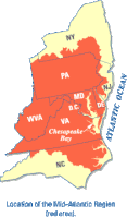
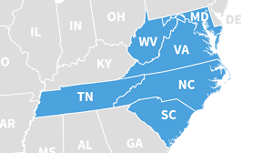
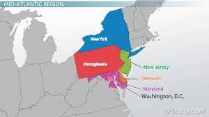
Easy to tell that the 00z and 06z runs were less then exciting. My recollection is that DT stated he considered N NC as part of the southern mid-atlantic region. I did a Google search for "mid atlantic region" and went to images. Most run from VA up to NY. However, there is certainly some variance - even TN made one map (from some doctor's group). The first image is from Wikipedia. So I'd say there's nothing set in stone as to where the borders for the mid atlantic region is. However, I beleive DT has clearly stated what he refers to as the southern extent of the mid atlantic. I'm not sure where he says the northern boundary is, but I don't really care as well.
-
The further out the models forecast, the less accurate they are. Think of the climate models from 10-15 years ago showing us embarking on a dustbowl, yet here we are being quite wet overall in the southeast over the last 5 years. TW
-
What had looked like a long term major thaw now looks like a run of the mill thaw. No guarantees yet thought. TW
-
Just goes to show that early February is not set in stone in any way shape or form as of yet. TW
-
Stark changes in the 12z GFS eh? TW
-
I've had a few flakes in Colfax. 36.0. TW
-
2023-2024 Fall/Winter Mountain Thread
tarheelwx replied to The Alchemist's topic in Southeastern States
Perfect. That's exactly what I was looking for! TW -
2023-2024 Fall/Winter Mountain Thread
tarheelwx replied to The Alchemist's topic in Southeastern States
I could use some input from you guys in the NC mountains. My first grandchild is due to arrive February 5th in Boone. My wife and I are considering buying a house up that way, but don't want to be right in Boone - but probably within 30-40 minutes of the Boone/Blowing Rock area. What areas would you recommend in order to experience the best (snow) of NC mountain weather? I'm thinking of which areas do really well with NW flow events as well as synoptic events. Thanks in advance. TW


