

The Iceman
-
Posts
12,303 -
Joined
-
Last visited
About The Iceman

- Birthday 12/17/1990
Recent Profile Visitors


-

E PA/NJ/DE Summer 2026 Obs/Discussion
The Iceman replied to PhiEaglesfan712's topic in Philadelphia Region
Looking like a lock that most area's receive < 1" precip from now through mid month. Best shot of any precip comes sunday but the timing is looking poor. Maybe some showers but not the best set up for convection despite the frontal passage. After that looks like another week of bone dry. -
E PA/NJ/DE Spring 2026 Obs/Discussion
The Iceman replied to PhiEaglesfan712's topic in Philadelphia Region
Every model was too far south with the precip today. Looks like southern PA on south should get at least another .25” today. Coming down at the moment here in Levittown and we had stuff come through overnight too for .15”. -
E PA/NJ/DE Summer 2026 Obs/Discussion
The Iceman replied to PhiEaglesfan712's topic in Philadelphia Region
I don't like to look ahead further than 15-20 days but first half of the month is looking normal maybe slightly below? Unfortunately looks dry as well so even though we got a brief respite from drought conditions. The nino precip anomalies are much more pronounced in the fall and winter months, it could be a few months before the drought truly breaks. -
E PA/NJ/DE Spring 2026 Obs/Discussion
The Iceman replied to PhiEaglesfan712's topic in Philadelphia Region
first half of june looks dry but comfortable at least -
E PA/NJ/DE Spring 2026 Obs/Discussion
The Iceman replied to PhiEaglesfan712's topic in Philadelphia Region
.8” overnight and this morning, 1.4” on the event, 2.6” since 5/20. Unfortunately looking dry again after this system scoots out. -
E PA/NJ/DE Spring 2026 Obs/Discussion
The Iceman replied to PhiEaglesfan712's topic in Philadelphia Region
.6” on the day, solid steady rain most of the afternoon. Another round of steady rain moving in that should most of the night. Expecting to finish well over an inch. 24 hour wundermap precip reports(personal weather stations) sure not looking like a miss for most. Excited to see the cocorahs reports tomorrow morning.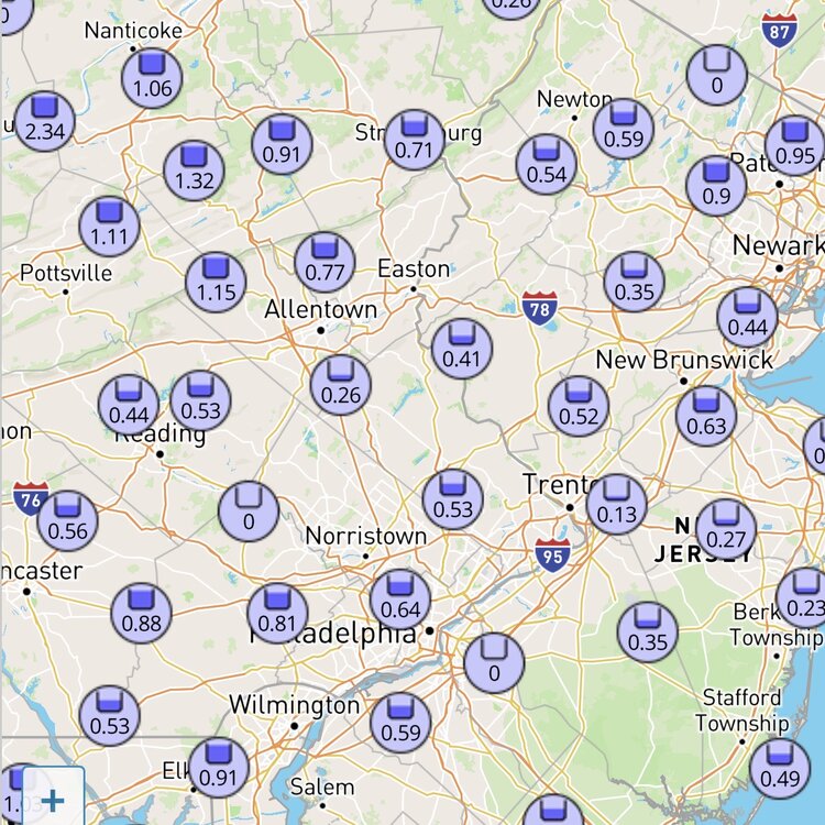
-
E PA/NJ/DE Spring 2026 Obs/Discussion
The Iceman replied to PhiEaglesfan712's topic in Philadelphia Region
The heaviest precipitation was always expected for later this afternoon and overnight…still looking on track for most areas to get .5-1.5” today and tonight with more coming tomorrow night and Monday. -
E PA/NJ/DE Spring 2026 Obs/Discussion
The Iceman replied to PhiEaglesfan712's topic in Philadelphia Region
.87” on the week, still looking good for 1-2”+ this weekend. -
E PA/NJ/DE Spring 2026 Obs/Discussion
The Iceman replied to PhiEaglesfan712's topic in Philadelphia Region
Guidance has really converged now on 2-3"+ region wide of rain through Monday. Sucks that the holiday weekend is looking like a complete washout all 3 days but it's much needed. Nothing looks overtly heavy either, just 3 days of moderate steady on and off rain so it should just be a good groundwater replenishment. -
E PA/NJ/DE Spring 2026 Obs/Discussion
The Iceman replied to PhiEaglesfan712's topic in Philadelphia Region
https://www.spc.noaa.gov/climo/reports/yesterday.html -
E PA/NJ/DE Spring 2026 Obs/Discussion
The Iceman replied to PhiEaglesfan712's topic in Philadelphia Region
I didn't get much either, but it did at least wet the ground... I didn't even bother to check the gauge, probably .05" tops. -
E PA/NJ/DE Spring 2026 Obs/Discussion
The Iceman replied to PhiEaglesfan712's topic in Philadelphia Region
TTN and PHL record high is 94 for 5/20, KABE is 92. All 3 should have a shot at breaking it. SPC has upgraded the area to a slight risk for wind this afternoon/evening, looks like we should see several rounds of scattered storms beginning after 18z then most models are showing an area of steady rain with the front now overnight into tomorrow morning, should hopefully be a decent soaking. This weekend is also looking like a much needed washout, it's a shame though it's Memorial Day weekend. Maybe we can get Sunday mostly dry, but looking like showers/rain/cool most of the weekend ...Ohio Valley into the Mid-Atlantic and Southern New England... On the southern fringe of upper troughing over eastern Canada and the Great Lakes, a weak/convectively augmented mid-level shortwave trough will progress northeastward across the OH Valley and central Appalachians through the day, eventually reaching the Mid-Atlantic tonight. Robust daytime heating of a modestly moist low-level airmass (surface dewpoints generally in the low to mid 60s) ahead of a surface cold front will aid in the development of moderate instability by early afternoon. Ongoing convection across OH/KY this morning may eventually strengthen as it encounters this destabilizing airmass, and additional thunderstorms are expected to develop along/near the cold front by mid afternoon from the central Appalachians into portions of the Mid-Atlantic and southern New England. Stronger flow aloft will tend to lag/remain north of the cold front, but modest enhancement to the west-southwesterly mid-level flow along/near the front should support around 20-30 kt of deep-layer shear. This will be sufficient for some updraft organization with mainly multicells expected, although marginal supercell structures may occur. Low-level lapse rates are expected to become quite steep through the day, evidenced by a general lack of clouds on recent visible satellite imagery from central/eastern WV into the Mid-Atlantic. This will likely aid efficient downward momentum transfer in convective downdrafts, with scattered severe/damaging winds possible as multiple clusters spread east-northeastward through the afternoon/evening. Isolated hail may also occur with the stronger cores. A Slight Risk for severe/damaging winds has been introduced from parts of WV to southern New England given increased confidence in multiple clusters traversing a narrow zone along/ahead of the front. -
E PA/NJ/DE Spring 2026 Obs/Discussion
The Iceman replied to PhiEaglesfan712's topic in Philadelphia Region
Can’t say I was expecting a severe thunder warning today. Big time wind out ahead of this cell though. -
E PA/NJ/DE Spring 2026 Obs/Discussion
The Iceman replied to PhiEaglesfan712's topic in Philadelphia Region
Several CAMs had this modeled overnight, surprised mt holly didn’t throw 20% pops to cta. -
E PA/NJ/DE Spring 2026 Obs/Discussion
The Iceman replied to PhiEaglesfan712's topic in Philadelphia Region
Looks like PHL is going to tie the all time May high temp at 97F but not break it. Back down to 96F at 4pm. topped out at 96F imby down to 94F now. doesnt look like anyone hit triple digits.


