Dino
-
Posts
502 -
Joined
-
Last visited
About Dino

- Birthday 09/24/1987
Recent Profile Visitors
1,467 profile views


-
 Dino changed their profile photo
 -
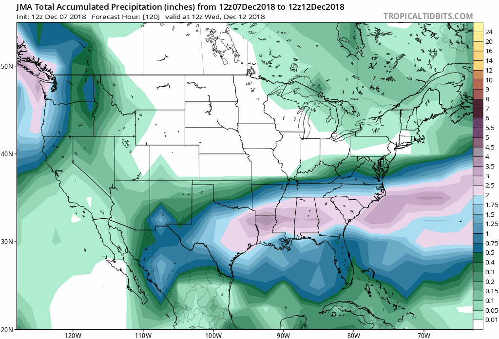
FWIW, the JMA model also shifted the heavy precip shield north...looks significant Dusting off these models lol - anyone got the latest Korean model?

-
The north trend noted in forecast discussion: Perhaps the most notable and significant feature affecting the upcoming system is a compact shortwave diving southeast from the Hudson Bay vicinity. This shortwave is rotating around a larger cyclonic gyre centered over southeastern Canada near 60 W. This upper pattern has acted to enhance confluence over northern New England southward toward the Mid-Atlantic, which is resulting in the more west to east low track out to sea to our south. However, this shortwave feature to the north has appeared to deepen a bit more than forecast over the last 12-24 hours, resulting in subsequent subtle downstream height rises. It`s not much, but it appears it may be just enough to weaken the confluence near and to our north a touch, allowing a northward shift in the tight northern edge of the snowfall from low pressure passing to our south. As such, 12z guidance has unanimously shifted northward. Mean QPF from model output has risen to nearly an inch at the southern most reaches of our CWA (southern Nelson County), and just under a half inch near CHO. The northern edge of accumulating snow remains a challenge, but there is a non- zero/increasing chance for flurries or a light coating of snow as far north as I-66/US-50, in line with the northern edge of a baroclinic leaf developing upstream on satellite (marking the northern edge of stronger synoptic upward motion).
-
CMC pushes north, Euro trending north, HRDRPS is north, RGEM is north. Dang, even the GFS has been shifting north since 0z Euro is catching on to dynamics better -- Seriously think this will pivot -- snow up through Baltimore and possibly Philly. HOT sea surface temps off the coast...looking good
.thumb.jpg.a23b6e01ab6212d1729097e508f9a17c.jpg)
-
December 2018 General Discussion & Observations
Dino replied to Zelocita Weather's topic in New York City Metro
Every winter same thing. Suppressed to the south now, then soon we will be worrying that it will pass way north of us. I say lock it in - 10" from Richmond to NYC. -
November 2018 Discussions & Observations Thread
Dino replied to Rtd208's topic in New York City Metro
FV3-GFS is close to a One-Two-Punch scenario along mid-atlantic and northeast November 29th & Dec 2nd. -
November 2018 Discussions & Observations Thread
Dino replied to Rtd208's topic in New York City Metro
Exciting - we started the winter off fantastically - the December 2nd Storm looks VERY interesting. The Arctic Oscillation index straight up plunges almost off the chart end of November and pops back up Dec -- looks extreme..thumb.jpg.6c2188ba3c18c11702c9a4c1a969bc45.jpg)
-
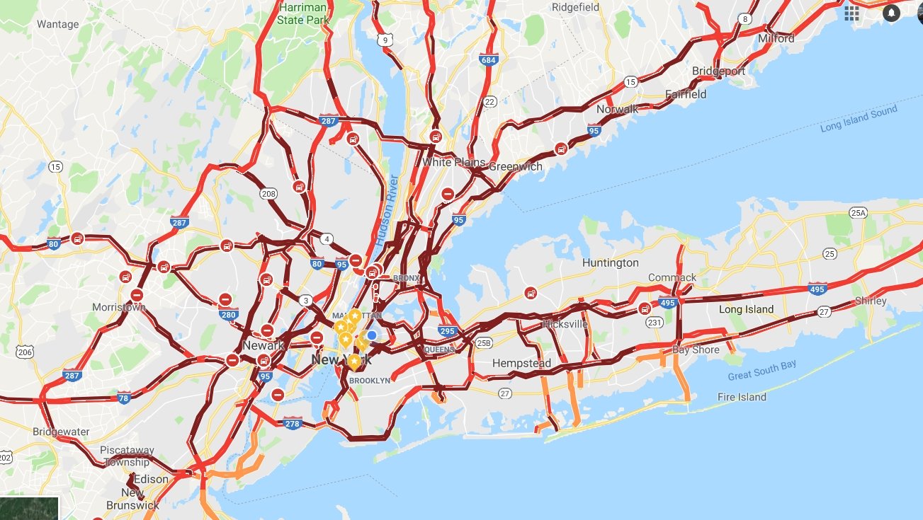
I know right! Atlanta is gonna have a field day with this news tomorrow. I can’t believe what I’m seeing - just search NYC Traffic on twitter and look at the insanity. The morning news tomorrow is going to be wild.
-
Unreal —over 1000 reports of trees down or damaged across NYC https://twitter.com/nycspeakercojo/status/1063271539813031936?s=21 https://twitter.com/samuelhartson/status/1063246366955188224?s=21 https://www.nbcnewyork.com/news/local/Trees-Fall-Across-Manhattan-New-York-Tri-State-Snowstorm-500646681.html and here’s more gridlock in Manhattan: https://twitter.com/kendisgibson/status/1063275941277966336?s=21
-
caught this car slide a bit heading onto the queensboro - you see how icy the roads were earlier
-
big mess - just constant sirens in LIC. the queensboro bridge has been backed up since the first flakes started
-
Port Authority shut down the bus terminal https://nypost.com/2018/11/15/port-authority-bus-terminal-closed-due-to-snowstorm-overcrowding/
-
wow and the temp keeps dropping -- down to 28 now in LIC. Lighter snow moving in now
-
Yikes - so glad i never have to drive on the LIE anymore... It's pretty obvious nobody prepped roads for this. I'm seeing 1 to 2 hr traffic delays in all directions
-
wow, the snowfall pretty much has stayed the same intensity this whole time. Can't see far outside my window. Everything is covered, cars having rough time driving around side roads. The temperature has steadily DROPPED as well. Started at 33 and now down to 29. Hoping to dryslot before the rain comes in.
-
Interesting that the NAM3K, 12K, HRRR, HRDRPS, and all the WRF's showed more than 2" of snow consistently for the area while the GFS and RGEM were showing Trace-to-2" roughly.

.jpg.66f6c70fc9a76520bbce6706100d67a0.jpg)

.jpg.e756f2c8938e29fb5c480a4d5cf7f87c.jpg)