MCS_hunter Posted August 28, 2014 Share Posted August 28, 2014 I figured I would get a thread started for the possibility of severe weather this weekend (mainly Sunday). Spc had a Day 5 outlook for Sunday and now has an expanded Day 4. ...DISCUSSION... THE GFS AND ECMWF APPEAR TO BE IN FAIRLY GOOD AGREEMENT THROUGH ROUGHLY DAY 6 /TUE 9-2/ WITH RESPECT TO THE EVOLUTION OF THE LARGE-SCALE PATTERN. BOTH MODELS DEPICT THE ADVANCE OF A FAIRLY STRONG UPPER TROUGH INTO THE CENTRAL U.S. DAY 4 /SUN 8-31/...ALONG WITH AN ASSOCIATED/SHARP COLD FRONTAL PROGRESSION. ON DAY 5...THE MAIN PUNCH OF SHORT-WAVE ENERGY WITHIN THE LARGER-SCALE TROUGH IS PROGGED TO SHIFT QUICKLY NEWD ACROSS THE GREAT LAKES AND INTO/ACROSS ONTARIO...LEAVING A MUCH-LESS-AMPLIFIED CYCLONIC FLOW FIELD IN ITS WAKE. BY DAY 6...A NEARLY ZONAL UPPER PATTERN IS FORECAST ACROSS THE U.S. -- THOUGH A TROUGH SHIFTING SEWD OUT OF THE GULF OF AK/WRN CANADA WILL BEGIN AFFECTING THE PAC NW LATE. MODEL DIFFERENCES WITH RESPECT TO THE HANDLING OF THIS TROUGH THROUGH BECOME INCREASINGLY APPARENT DAY 7 AND BEYOND. THE MOST SUBSTANTIAL SEVERE RISK THIS PERIOD REMAINS APPARENT DAY 4 FROM THE CENTRAL PLAINS NEWD TO THE UPPER MS VALLEY...AS THE UPPER TROUGH SHIFTS INTO/ACROSS THIS AREA. AS THE ASSOCIATED COLD FRONT ADVANCES INTO A MOIST/DESTABILIZING AFTERNOON AIRMASS...VIGOROUS THUNDERSTORM DEVELOPMENT IS EXPECTED TO OCCUR. WITH A BELT OF 40 TO 50 KT SWLY FLOW PROGGED TO SPREAD ACROSS THE MID MO VALLEY VICINITY THROUGH THE DAY ATOP LOW-LEVEL WARM-SECTOR SSELYS...SHEAR WILL BECOME FAVORABLE FOR ROTATING STORMS. AS A RESULT...A RISK FOR LARGE HAIL AND LOCALLY DAMAGING WINDS -- AND POSSIBLY A FEW TORNADOES -- SEEMS LIKELY TO MATERIALIZE...PARTICULARLY WITHIN A ZONE FROM NRN KS NNEWD INTO MN/WRN WI DURING THE AFTERNOON AND EARLY EVENING HOURS...AND THEN INTO IA/NWRN MO THROUGH THE EVENING HOURS. WIDESPREAD CONVECTION IS FORECAST AT THE START OF DAY 5 ACROSS THE MID AND UPPER MS VALLEY/UPPER GREAT LAKES AREA...AS THE STRONGEST UVV SPREADS NEWD INTO ONTARIO WITH TIME. WIDESPREAD CLOUDS/PRECIPITATION AND THUS LIMITED DESTABILIZATION POTENTIAL WOULD APPEAR TO BE A LIMITING FACTOR FOR SIGNIFICANT SEVERE WEATHER. BY DAY 6...A BELT OF FAST WLY FLOW ALOFT SHOULD RESIDE ACROSS THE NRN HALF OF THE CONUS...BUT WITH A WEAKENING/INCREASINGLY W-E ORIENTED FRONT EXTENDING ACROSS THE MIDWEST AND INTO THE PLAINS...LOCATION AND DEGREE OF SEVERE POTENTIAL APPEAR TOO UNCERTAIN TO WARRANT ANY AREAL HIGHLIGHTS ATTM. ..GOSS.. 08/28/2014 Link to comment Share on other sites More sharing options...
MCS_hunter Posted August 28, 2014 Author Share Posted August 28, 2014 12Z GFS for Omaha on Sunday night: Link to comment Share on other sites More sharing options...
andyhb Posted August 28, 2014 Share Posted August 28, 2014 As shown there, 12z GFS had some absolutely nasty soundings in E NE on Sunday, such as this one south of Columbus at 21z. Link to comment Share on other sites More sharing options...
Quincy Posted August 28, 2014 Share Posted August 28, 2014 Greatest threat looks like Sunday and the models have been fairly consistent in zoning in on the area from northeastern Kansas into southeastern Nebraska, far northwestern Missouri and southwestern Iowa. The 12z Euro came in with a strengthening LLJ of 40-50 knots across this area, with a SW flow at 850 and a backed near-surface flow of SSE across this area. Morning cloud debris is a concern, although the Euro looks to minimize that and allows for SBCAPE to increase to 2,000 to 3,000 J/kg. Precip blossoms intensely across southeastern Nebraska by late afternoon and early evening. Although severe appears to be increasingly probable, there's also a heavy rain signal, which parts of the area do not need either. Link to comment Share on other sites More sharing options...
andyhb Posted August 28, 2014 Share Posted August 28, 2014 Seems like rinse, wash and repeat for the Nebraska threats this year, the OAX CWA has been hit particularly hard and as it looks right now, they are in the middle of the highest risk region for this one. Also WRT the Euro, its LLJ becomes southerly by 21z Sunday, rather than southwesterly. Link to comment Share on other sites More sharing options...
bdgwx Posted August 28, 2014 Share Posted August 28, 2014 12Z Euro for the southeast corner of Nebraska looks ripe. There is a pocket, albeit small, where 0-6km shear is 50+ kts over the top of a backed 0-1km shear vector of 25kts. Link to comment Share on other sites More sharing options...
andyhb Posted August 29, 2014 Share Posted August 29, 2014 Well that was an anticlimactic D3 outlook. Not much continuity from the D4/5 despite the GFS/Euro holding generally steady. Link to comment Share on other sites More sharing options...
bdgwx Posted August 29, 2014 Share Posted August 29, 2014 They also dropped it from 30% (the only option for D4-D8) to 15%. LIke you said the GFS/ECMWF still looks pretty potent. I wonder if they're taking the NAM into consideration now. Link to comment Share on other sites More sharing options...
AgeeWx Posted August 30, 2014 Share Posted August 30, 2014 Little quiet in here today, what's everyone thinking for tomorrow? The shear is a little weak but the instability is impressive. Shear vectors are nicely perpendicular to the front but frontal speed could be a problem if the divergence arrives earlier than expected and erodes whatever cap is left. Lapse rates are impressive but eventually everything is going to go, I think. Trying to debate whether or not to make the drive from Grand Forks. Link to comment Share on other sites More sharing options...
Chinook Posted August 30, 2014 Share Posted August 30, 2014 Looking at a forecast sounding for NW Iowa for 00z tomorrow, I see there's about 3000-4000 J/kg of CAPE, 0-3km helicity of 200 m2/s2, The shear looks a little complicated, with 40kt at 700mb, 25 kt at 500mb, and 40 kt at 400mb. The SPC SREF plots show that the STP will be from 2 to 4. I think this area could get a few supercells. I think there will be 50-100 hail/wind reports with a couple of tornadoes. None of the recent severe weather setups have been amazing. 1730z Day 2 SPC discussion (refer to full discussion) -- FORECAST SOUNDINGS ALONG THE INSTABILITY CORRIDOR FROM OMAHA NEB NNEWD TO MINNEAPOLIS MN FOR 00Z/MONDAY SHOW AN IMPRESSIVE THERMODYNAMIC ENVIRONMENT WITH MLCAPE IN THE 1500 TO 2500 J/KG RANGE WITH 850 TO 500 MB LAPSE RATES NEAR 8.0 C/KM. THIS COMBINED WITH 0-6K SHEAR AROUND 40 KT SHOULD BE FAVORABLE FOR SUPERCELLS WITH LARGE HAIL. Link to comment Share on other sites More sharing options...
MCS_hunter Posted August 30, 2014 Author Share Posted August 30, 2014 I'm thinking if you want to have a chance of seeing tornadoes your going to have to be near Sioux City, IA. But, a big squall line looks probable so if storms merge too fast that tornado chance could be low. Personally, I think this setup is garbage. Link to comment Share on other sites More sharing options...
Jim Marusak Posted August 30, 2014 Share Posted August 30, 2014 I'm thinking if you want to have a chance of seeing tornadoes your going to have to be near Sioux City, IA. But, a big squall line looks probable so if storms merge too fast that tornado chance could be low. Personally, I think this setup is garbage. garbage for tornadoes, yea, they'll be the early on mode, like you said, SUX-RWF-OMA. but squall-line based wind and hail damage, probably one of the better setups of the year. kinda sad really for a severe-weather season/year in Minnesota. Saskatchewan seems like they have had a better severe season than we have had. but i guess that's not a bad thing given the flooding we had earlier this year in the Minnesota River Valley. Link to comment Share on other sites More sharing options...
Jonbo Posted August 31, 2014 Share Posted August 31, 2014 Considering I'm in severe weather withdrawal, I'll take a Squall line coming through my area. Link to comment Share on other sites More sharing options...
bdgwx Posted August 31, 2014 Share Posted August 31, 2014 I'm with you all. It's not a very good setup for tornadoes. The wind shear at the various levels are out of phase. And depending on which model you look at the bulk shear is on the low side for supercells anyway. LCL heights are another matter. I think the ECMWF still makes the best case, but I'm not super impressed with it either. UH outputs from the storm scale models aren't much to write about except for the HRW-ARW which is simulating one good cell. I still think a moderate level outbreak could be in the cards though for the hail and high winds. Link to comment Share on other sites More sharing options...
Chad A Posted August 31, 2014 Share Posted August 31, 2014 Personally liking the I80 corridor from Kearney to Grand Island maybe out to York Nebraska for Sunday - for a tornado chance. Subtle convergence along front and a pretty strong 40 to 50 kt 500 mb streak punching through there at just the right time - should be enough ( 21 to 0z ). NAM hinting at secondary surface low development in western KS Nebraska that may enhanced that boundary and give us more backed flow ahead of it into Central Nebraska - giving us a more curved hodograph with south to southeasterly winds at surface curving back to westerly at mid levels. 0z GFS picking up on similar feature - though not as deep a low. Link to comment Share on other sites More sharing options...
andyhb Posted August 31, 2014 Share Posted August 31, 2014 Looking at Stormtrack, I'm kind of confused about how so many people there are basically going all in on the NAM despite it's terrible performance overall this year with virtually every setup. Link to comment Share on other sites More sharing options...
MCS_hunter Posted August 31, 2014 Author Share Posted August 31, 2014 Looking at Stormtrack, I'm kind of confused about how so many people there are basically going all in on the NAM despite it's terrible performance overall this year with virtually every setup. +1 It should have lost almost all credibility by now Link to comment Share on other sites More sharing options...
Jonbo Posted August 31, 2014 Share Posted August 31, 2014 SPC going with 10% tor from Lincoln to Omaha to Des Moines and northwest to the IA/MN/SD border. Link to comment Share on other sites More sharing options...
bdgwx Posted August 31, 2014 Share Posted August 31, 2014 The SPC dropped the 10% area on its latest update. Let's see how well the HopWRF does today. It is focusing on northeast Nebraska and into northwest Iowa. Link to comment Share on other sites More sharing options...
Thundersnow12 Posted August 31, 2014 Share Posted August 31, 2014 I'd be sitting in Columbus right now, convergence bullseye, good heating should continue and hope that area goes once nose of jet arrives later on. Link to comment Share on other sites More sharing options...
Jim Marusak Posted August 31, 2014 Share Posted August 31, 2014 http://www.spc.noaa.gov/products/md/md1645.html well, there is this MD now out for initiation in the next little bit for whatever happens here. how bad, I'm not sure. but if I were to speculate on watch configuration, as I did on twitter, here's how I see it... tornado watch (tornado/winds/hail): AXN (Alexandria MN) > STC (St Cloud) > AXA (Algona IA) > STJ > HLC (Hill City, KS) > YKN (Yankton) > ETH (Wheaton) severe t-storm watch (mainly winds, maybe hail and flash flooding): STC > RPD (Rice Lake) > ONA (Winona) > ALO (Waterloo IA) > IRK (Kirksville) > edge of torn box but that's my opinion. what's your thoughts? Link to comment Share on other sites More sharing options...
MCS_hunter Posted August 31, 2014 Author Share Posted August 31, 2014 Tornado watch only extends to the Iowa/Minnesota border. Not great probabilities to go along with it but given this setup, it's not a surprise. Link to comment Share on other sites More sharing options...
Jim Marusak Posted August 31, 2014 Share Posted August 31, 2014 Tornado watch only extends to the Iowa/Minnesota border. Not great probabilities to go along with it but given this setup, it's not a surprise. true. severe t-storm mode will probably be the main one to worry about later on. but I do understand there is a "Journey" concert going on over in Norfolk NE attm. I guess they didn't stop believin' over there. just hope they can get the fans out of there for the storm coming up from Boone County NE (the one in Pierce should stay north of where the concert is, hopefully). Link to comment Share on other sites More sharing options...
MCS_hunter Posted August 31, 2014 Author Share Posted August 31, 2014 These storms are going linear pretty fast and there is a lot of crapvection stabilizing things to the east in Iowa. I have some friends chasing in northwest IA and I feel sorry for them. Link to comment Share on other sites More sharing options...
Jonbo Posted September 1, 2014 Share Posted September 1, 2014 Gowrie may have taken a hit from a tornado. Well defined notch in the line as it's heading across central and North Iowa. Packing 80mph winds at times. Link to comment Share on other sites More sharing options...
Chinook Posted September 1, 2014 Share Posted September 1, 2014 Cleveland vs. KC has been delayed in extra innings by this large rainy squall line in Kansas City. I wonder if they will ever finish it. Link to comment Share on other sites More sharing options...
Chinook Posted September 1, 2014 Share Posted September 1, 2014 Three to five inches of rain fell south of I-70 in Kansas Link to comment Share on other sites More sharing options...
ArkieOkie Posted September 2, 2014 Share Posted September 2, 2014 I know this is south of the area y'all have been discussing, but there's some pretty fierce activity southwest of Joplin, MO on the KS/OK line right now. Link to comment Share on other sites More sharing options...
SmokeEater Posted September 2, 2014 Share Posted September 2, 2014 I know this is south of the area y'all have been discussing, but there's some pretty fierce activity southwest of Joplin, MO on the KS/OK line right now.If it turns left at all, that tornado warned cell is gonna possibly head for Joplin. Link to comment Share on other sites More sharing options...
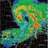
MCS_hunter Posted September 2, 2014 Author Share Posted September 2, 2014 Well it looks like today was the day for tornadoes. 3 separate supercells in KS/MO with good hook echoes and 1 had a confirmed elephant trunk tornado. Link to comment Share on other sites More sharing options...

Recommended Posts
Archived
This topic is now archived and is closed to further replies.