Mike.Ventrice Posted August 16, 2012 Share Posted August 16, 2012 Hi all, I'm overly gushy about this wave and chances for genesis during the upcoming week. The IR image below shows the nice interaction with the wave and the diurnal cycle of convection over and downstream of the Guinea Highlands Region. We might expect convection to fire up over the coast between 15-18Z and propagate northward down the lee of the Guinea Highlands as the wave moves out over the Atlantic later tonight. We are also observing the passage of the strong eastward propagating convectively-coupled Kelvin wave over the Atlantic. Note that the entire Atlantic ITCZ is active today. I want to illustrate how strong this Kelvin wave is (for it is also coupled with the convectively active phase of the MJO): This wave has swapped the total Positive VP200 signature that has been over the Atlantic since roughly June (there has been one other weaker Kelvin wave that swapped it to negative briefly) to a large area of negative VP200 values. Given the relative state of the tropics, and in agreement with the ECMWF/GFS pouch products (GFS forecast below) I'm all in for this wave. **EDIT** Sorry all- I forgot I am not allowed to post those results. I meant to use the GFS! Link to comment Share on other sites More sharing options...
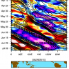
Mike.Ventrice Posted August 16, 2012 Author Share Posted August 16, 2012 To illstrate the diurnal cycle of convection at the coast of West Africa during boreal summer, here's Figure 3 from my first 2012 paper: Ventrice, M. J., C. D. Thorncroft, and M. A. Janiga, 2012a: Atlantic tropical cyclogenesis: A three-way interaction between an African easterly wave, diurnally varying convection, and a convectively-coupled atmospheric Kelvin wave. Mon. Wea. Rev., 140, 1108-1124. Link to comment Share on other sites More sharing options...
am19psu Posted August 16, 2012 Share Posted August 16, 2012 Yep. The signals have been strong for quite a few days now that this will be the first major of the season. Of note, the longer range Euro ensemble members are recurving this thing quite a bit farther west than the ops would imply. Link to comment Share on other sites More sharing options...
Mike.Ventrice Posted August 16, 2012 Author Share Posted August 16, 2012 I edited the post- sorry totally forgot I cant post ec-products. My apologizes Link to comment Share on other sites More sharing options...
HurricaneJosh Posted August 16, 2012 Share Posted August 16, 2012 Yep. The signals have been strong for quite a few days now that this will be the first major of the season. Of note, the longer range Euro ensemble members are recurving this thing quite a bit farther west than the ops would imply. How far W? Link to comment Share on other sites More sharing options...
canderson Posted August 16, 2012 Share Posted August 16, 2012 I'm in Bermuda this Sunday to next Sunday via cruise. Put money on this forming and screwing me over. Link to comment Share on other sites More sharing options...
HurricaneJosh Posted August 16, 2012 Share Posted August 16, 2012 Why do people schedule cruises in hurricane zones during the climatological peak of the season? It never ceases to puzzle me. Link to comment Share on other sites More sharing options...
canderson Posted August 16, 2012 Share Posted August 16, 2012 Why do people schedule cruises in hurricane zones during the climatological peak of the season? It never ceases to puzzle me. Because we gamble and purchase travel insurance so we don't care. I'd not do anything out of Florida this time if year but a NY to Bermuda run is a safer bet. Link to comment Share on other sites More sharing options...
HurricaneJosh Posted August 16, 2012 Share Posted August 16, 2012 Because we gamble and purchase travel insurance so we don't care. I'd not do anything out of Florida this time if year but a NY to Bermuda run is a safer bet. If you don't care then I guess you're not worried about it. I still don't understand why the cruise companies schedule that-- or why anyone would insure that sort of trip. NY to Bermuda is just as likely to get hit as FL. Systems up there won't be as strong, but plenty disruptive with regard to a cruise. Take your cruises in the winter. Link to comment Share on other sites More sharing options...
Superstorm93 Posted August 16, 2012 Share Posted August 16, 2012 I've been watching this for days now as well. ECMWF EPS Control suggests a pattern that could provide this with a more westerly component that the GFS suggests. Bill 2009 redux? Link to comment Share on other sites More sharing options...
mappy Posted August 16, 2012 Share Posted August 16, 2012 Why do people schedule cruises in hurricane zones during the climatological peak of the season? It never ceases to puzzle me. Same reason why people plan December weddings or child births.... We don't think ahead Link to comment Share on other sites More sharing options...
canderson Posted August 16, 2012 Share Posted August 16, 2012 If you don't care then I guess you're not worried about it. I still don't understand why the cruise companies schedule that-- or why anyone would insure that sort of trip. NY to Bermuda is just as likely to get hit as FL. Systems up there won't be as strong, but plenty disruptive with regard to a cruise. Take your cruises in the winter. Wish I could! But it only goes May to August and work won't allow us to travel up except August to November. This is their last season sailing to Bermuda, to boot.That said this guy will take a while to move so it wouldn't get near Bermuda until a week out probably right? Don't these take 6-7 days to travel that far? Link to comment Share on other sites More sharing options...
HurricaneJosh Posted August 16, 2012 Share Posted August 16, 2012 Same reason why people plan December weddings or child births.... We don't think ahead My sister got married in December. It was quite beautiful, actually. She's not an icep*ss or anything, it just happen that way. Back on topic... A Bill scenario would be a bit annoying. What are the chances that this makes it across into the W Caribbean and/or Gulf? Link to comment Share on other sites More sharing options...
HurricaneJosh Posted August 16, 2012 Share Posted August 16, 2012 Wish I could! But it only goes May to August and work won't allow us to travel up except August to November. This is their last season sailing to Bermuda, to boot. That said this guy will take a while to move so it wouldn't get near Bermuda until a week out probably right? Don't these take 6-7 days to travel that far? Depends how fast it's moving, but usually around a week, give or take. Laws of probability say you'll be fine. If not, you'll experience some interesting weather. So it's win-win. Link to comment Share on other sites More sharing options...
CoastalWx Posted August 16, 2012 Share Posted August 16, 2012 Euro is pretty strong with this potential TC as well. Tries to suck it north, but ridging then builds and brings it back on a NW track by d10. At this stage it's several hundred of miles NNE of the Antilles. Link to comment Share on other sites More sharing options...
Riptide Posted August 16, 2012 Share Posted August 16, 2012 I've been watching this for days now as well. ECMWF EPS Control suggests a pattern that could provide this with a more westerly component that the GFS suggests. Bill 2009 redux? From what I can tell, looking at the long-range pattern and the GFS/ECM ensembles. Timing is important and this is a situation where only an absolute recurve(Fabian, Bill) or west-tracking event (Ike, Andrew, etc) can occur. Once we approach September, teleconnections suggest that the persistent low pressure regime that has existed along the East Coast during August will move out and be replaced by a semi-permanent ridge as a result of changes in the AO and NAO. The key here is the rate of development and forward speed, if the system fails to capture the persistent weakness at 60W; it may not get another chance to escape until reaching the conus. Link to comment Share on other sites More sharing options...
Superstorm93 Posted August 16, 2012 Share Posted August 16, 2012 18z GFS 500mb pattern looks somewhat interesting. Trof over the East sticks around much too long to allow a ridge to build in, but that's over 9 days away. I'm not sold on an insta-fish solution just yet, especially if this stays weaker than the globals suggest. Sure enough, developing system after our African wave will find itself much farther west. CMC...think different! Link to comment Share on other sites More sharing options...
Superstorm93 Posted August 17, 2012 Share Posted August 17, 2012 94L AL, 94, 2012081700, , BEST, 0, 110N, 172W, 20, 1010, DB * ATLANTIC SHIPS INTENSITY FORECAST * * GOES PROXY USED, OHC AVAILABLE * * INVEST AL942012 08/17/12 00 UTC * TIME (HR) 0 6 12 18 24 36 48 60 72 84 96 108 120 V (KT) NO LAND 20 22 25 30 35 45 55 65 75 85 92 99 104 V (KT) LAND 20 22 25 30 35 45 55 65 75 85 92 99 104 V (KT) LGE mod 20 21 21 23 24 28 33 40 50 63 75 86 94 Link to comment Share on other sites More sharing options...
thewxmann Posted August 17, 2012 Share Posted August 17, 2012 The future track of 94L seems to hinge strongly upon a TUTT that is forecasted to develop over the central ATL, which leaves behind a weakness. For at least the next five days though, a mid-lvl ridge should be able to steer 94L on a westerly or even slightly WSW trajectory. But since models can't really forecast TUTT's and ULL's that well, it's hard to gauge what happens after that. Probably will be difficult until Gordon exits stage right. Link to comment Share on other sites More sharing options...
thewxmann Posted August 17, 2012 Share Posted August 17, 2012 New ECM is much further south and west, BTW... seems similar to 0Z GFS through hr 168. Link to comment Share on other sites More sharing options...
Superstorm93 Posted August 17, 2012 Share Posted August 17, 2012 ECM is much weaker through the first five days. Good for all who want a western track, but bad for those with no patience... Sent from Tapatalk Link to comment Share on other sites More sharing options...
Floydbuster Posted August 17, 2012 Share Posted August 17, 2012 This appears to be major Hurricane Helene in the making. Link to comment Share on other sites More sharing options...
yoda Posted August 17, 2012 Share Posted August 17, 2012 This appears to be major Hurricane Helene in the making. Because you think so? Link to comment Share on other sites More sharing options...
Floydbuster Posted August 17, 2012 Share Posted August 17, 2012 Because you think so? No because it's the strongest tropical wave to exit Africa all season in the middle of August and the early model data indicates a major hurricane within 120 hrs and the next name is Helene. Link to comment Share on other sites More sharing options...
yoda Posted August 17, 2012 Share Posted August 17, 2012 No because it's the strongest tropical wave to exit Africa all season in the middle of August and the early model data indicates a major hurricane within 120 hrs and the next name is Helene. I see SHIPS does, but I dont know that you can base pressure on system strength if you use globals... also considering EC is quite weak with 94L for a while Link to comment Share on other sites More sharing options...
Floydbuster Posted August 17, 2012 Share Posted August 17, 2012 I see SHIPS does, but I dont know that you can base pressure on system strength if you use globals... also considering EC is quite weak with 94L for a while There are always these discrepancies with globals early on. Link to comment Share on other sites More sharing options...
yoda Posted August 17, 2012 Share Posted August 17, 2012 There are always these discrepancies with globals early on. Well no duh, but stating MH in 5 days when the globals are all over the place is kinda silly Link to comment Share on other sites More sharing options...
Scott747 Posted August 17, 2012 Share Posted August 17, 2012 Yep. The signals have been strong for quite a few days now that this will be the first major of the season. Of note, the longer range Euro ensemble members are recurving this thing quite a bit farther west than the ops would imply. Well no duh, but stating MH in 5 days when the globals are all over the place is kinda silly Just sometimes the need to bash or question Naso isn't always the best route to take. It has already been stated in this thread about this being potentially the first MH of the season. Link to comment Share on other sites More sharing options...
free_man Posted August 17, 2012 Share Posted August 17, 2012 If you don't care then I guess you're not worried about it. I still don't understand why the cruise companies schedule that-- or why anyone would insure that sort of trip. NY to Bermuda is just as likely to get hit as FL. Systems up there won't be as strong, but plenty disruptive with regard to a cruise. Take your cruises in the winter. It's apples and oranges you are comparing. Link to comment Share on other sites More sharing options...
free_man Posted August 17, 2012 Share Posted August 17, 2012 0z Euro (appears to, from my very rough first view) bends what becomes a hurricane, back wnw just NE of PR. I'd pay to see that. Link to comment Share on other sites More sharing options...

Recommended Posts
Archived
This topic is now archived and is closed to further replies.