
Significant MCS/Severe Threat: June 19

Entry posted by Quincy ·
2,550 views
 A severe thunderstorm threat is expected to develop late this afternoon into the evening hours across portions of the northern Plains. The setup includes an area of surface low pressure ejecting from Wyoming toward the Nebraska/South Dakota border late today. At the same time or shortly thereafter, an embedded upper level shortwave swing through the Dakotas. The combination of kinematic support and strong instability will likely result in several severe thunderstorms with all severe weather hazards possible. The severe weather threat may continue well into the night as storms shift east-southeastward.
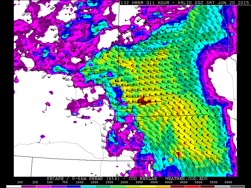
The computer models are in good agreement with the synoptic setup and even most of the mesoscale details seem fairly clear. The HRRR/NAM/RAP show an area of low pressure moving into east-central Wyoming by late afternoon with isolated thunderstorm development across much of eastern Montana. The initial development is closer to the upper level forcing at the time and in association with a frontal boundary interacting with moderate instability and modest wind shear. Further east, although stronger surface heating/instability are progged, a fairly strong cap should limit convection for most of the afternoon.
Between about 22z and 00z, surface heating looks sufficient to begin breaking the cap. At this time, robust thunderstorm development appears likely across southeastern Montana and far northeastern Wyoming. In the immediate downstream environment, a secondary warm front/differential heating boundary is showing up with the high resolution guidance. As it looks now, that should be draped roughly near the I-90 corridor from far northeastern Wyoming into the western half of South Dakota. It is here that strong instability and increasing wind fields should be very favorable for severe thunderstorms. Any discrete thunderstorms between 23z and 02z near this secondary boundary are expected to have the highest probability to produce tornadoes. The higher end instability scenarios appear overdone, but even the less dramatic GFS shows in excess of 2500 J/kg MLCAPE overlapped with 60 knots of bulk shear through much of western South Dakota.
Given such instability, the initial threats appear to be large to very large hail, followed by isolated tornadoes. A more substantial damaging wind threat likely develops during the evening hours further east. As the low level jet really ramps up and upper level winds increase, the kinematic environment should support a significant MCS, possibly a derecho. The exact placement of this convective system develops on how and where thunderstorms grow upscale. It appears that beginning in northwestern and moving into central South Dakota is where the model consensus stood as of this morning. This is also supported by an intense inflow environment with moderate elevated instability and a vigorous low level jet (in excess of 50-60 knots) ejecting from northern Nebraska into portions of South Dakota. While the convection-allowing models differ slightly with solutions, they all show an elevated threat of fairly widespread damaging winds into early Saturday morning across much of South Dakota.
This is a fairly interesting case, as this portion of the (western) northern High Plains does not have many significant tornado cases dating back to the early 1960s. One of the red flags for tornado development includes storm coverage as a result of capping. Nonetheless, regardless of geographic region, it is possible for a strong tornado to develop given the expected environment. If a strong tornado were to form, this would most likely be in western South Dakota or perhaps far southeastern Montana/far northeastern Wyoming. Compared with climatology, the projected severe weather parameters tonight fall into the high end of prior tornado cases for the region. Although wind fields intensify into the evening hours, a gradual loss of heating and a trend toward storm mergers may also mitigate the threat. The threat of most widespread impact will likely end up being damaging winds, even if a derecho does not form. For what it’s worth, the 09z SREF derecho probabilities are in excess of 50% for a large portion of South Dakota by 06z Saturday. A few severe thunderstorms are also possible across southern North Dakota and a rogue supercell cannot be ruled out in the Nebraska panhandle either.


0 Comments
Recommended Comments
There are no comments to display.
Create an account or sign in to comment
You need to be a member in order to leave a comment
Create an account
Sign up for a new account in our community. It's easy!
Register a new accountSign in
Already have an account? Sign in here.
Sign In Now